Lieuran-Cabrières
| Lieuran-Cabrières | ||
|---|---|---|
| Commune | ||
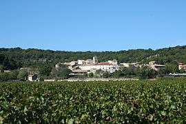 A general view of Lieuran-Cabrières | ||
| ||
 Lieuran-Cabrières Location within Occitanie region  Lieuran-Cabrières | ||
| Coordinates: 43°35′11″N 3°24′58″E / 43.5864°N 3.4161°ECoordinates: 43°35′11″N 3°24′58″E / 43.5864°N 3.4161°E | ||
| Country | France | |
| Region | Occitanie | |
| Department | Hérault | |
| Arrondissement | Lodève | |
| Canton | Mèze | |
| Intercommunality | Clermontais | |
| Government | ||
| • Mayor (2008–2014) | Alain Blanquer | |
| Area1 | 6.13 km2 (2.37 sq mi) | |
| Population (2008)2 | 266 | |
| • Density | 43/km2 (110/sq mi) | |
| Time zone | UTC+1 (CET) | |
| • Summer (DST) | UTC+2 (CEST) | |
| INSEE/Postal code | 34138 /34800 | |
| Elevation |
77–323 m (253–1,060 ft) (avg. 112 m or 367 ft) | |
|
1 French Land Register data, which excludes lakes, ponds, glaciers > 1 km2 (0.386 sq mi or 247 acres) and river estuaries. 2 Population without double counting: residents of multiple communes (e.g., students and military personnel) only counted once. | ||
.svg.png)
Lieuran-Cabrières (Occitan: Liuran) is a commune in the Hérault département in the Occitanie region in southern France.

Map
Population
| Historical population | ||
|---|---|---|
| Year | Pop. | ±% |
| 1962 | 152 | — |
| 1968 | 181 | +19.1% |
| 1975 | 137 | −24.3% |
| 1982 | 140 | +2.2% |
| 1990 | 166 | +18.6% |
| 1999 | 184 | +10.8% |
| 2008 | 266 | +44.6% |
See also
References
External links
| Wikimedia Commons has media related to Lieuran-Cabrières. |
This article is issued from
Wikipedia.
The text is licensed under Creative Commons - Attribution - Sharealike.
Additional terms may apply for the media files.