Saint-Pargoire
| Saint-Pargoire | ||
|---|---|---|
| Commune | ||
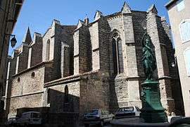 The church of Saint-Pargoire | ||
| ||
 Saint-Pargoire Location within Occitanie region  Saint-Pargoire | ||
| Coordinates: 43°31′43″N 3°31′11″E / 43.5286°N 3.5197°ECoordinates: 43°31′43″N 3°31′11″E / 43.5286°N 3.5197°E | ||
| Country | France | |
| Region | Occitanie | |
| Department | Hérault | |
| Arrondissement | Lodève | |
| Canton | Gignac | |
| Intercommunality | Vallée de l'Hérault | |
| Government | ||
| • Mayor (2008–2014) | Agnès Constant | |
| Area1 | 23.77 km2 (9.18 sq mi) | |
| Population (2008)2 | 1,847 | |
| • Density | 78/km2 (200/sq mi) | |
| Time zone | UTC+1 (CET) | |
| • Summer (DST) | UTC+2 (CEST) | |
| INSEE/Postal code | 34281 /34230 | |
| Elevation |
18–221 m (59–725 ft) (avg. 74 m or 243 ft) | |
|
1 French Land Register data, which excludes lakes, ponds, glaciers > 1 km2 (0.386 sq mi or 247 acres) and river estuaries. 2 Population without double counting: residents of multiple communes (e.g., students and military personnel) only counted once. | ||
.svg.png)
Saint-Pargoire is a commune in the Hérault department in the Occitanie region in southern France.
Population
| Historical population | ||
|---|---|---|
| Year | Pop. | ±% |
| 1793 | 1,181 | — |
| 1800 | 1,197 | +1.4% |
| 1806 | 1,391 | +16.2% |
| 1821 | 1,452 | +4.4% |
| 1831 | 1,496 | +3.0% |
| 1836 | 1,768 | +18.2% |
| 1841 | 1,806 | +2.1% |
| 1846 | 1,631 | −9.7% |
| 1851 | 1,686 | +3.4% |
| 1856 | 1,751 | +3.9% |
| 1861 | 1,776 | +1.4% |
| 1866 | 1,986 | +11.8% |
| 1872 | 2,004 | +0.9% |
| 1876 | 1,910 | −4.7% |
| 1881 | 1,498 | −21.6% |
| 1886 | 1,514 | +1.1% |
| 1891 | 1,557 | +2.8% |
| 1896 | 1,524 | −2.1% |
| 1901 | 1,640 | +7.6% |
| 1906 | 1,638 | −0.1% |
| 1911 | 1,696 | +3.5% |
| 1921 | 1,775 | +4.7% |
| 1926 | 1,750 | −1.4% |
| 1931 | 1,740 | −0.6% |
| 1936 | 1,706 | −2.0% |
| 1946 | 1,417 | −16.9% |
| 1954 | 1,422 | +0.4% |
| 1962 | 1,437 | +1.1% |
| 1968 | 1,482 | +3.1% |
| 1975 | 1,243 | −16.1% |
| 1982 | 1,209 | −2.7% |
| 1990 | 1,252 | +3.6% |
| 1999 | 1,357 | +8.4% |
| 2008 | 1,847 | +36.1% |
See also
References
| Wikimedia Commons has media related to Saint-Pargoire. |
This article is issued from
Wikipedia.
The text is licensed under Creative Commons - Attribution - Sharealike.
Additional terms may apply for the media files.