Castries, Hérault
| Castries | ||
|---|---|---|
| Commune | ||
 Chateau | ||
| ||
 Castries Location within Occitanie region  Castries | ||
| Coordinates: 43°40′47″N 3°58′56″E / 43.6797°N 3.9822°ECoordinates: 43°40′47″N 3°58′56″E / 43.6797°N 3.9822°E | ||
| Country | France | |
| Region | Occitanie | |
| Department | Hérault | |
| Arrondissement | Montpellier | |
| Canton | Le Crès | |
| Intercommunality | Montpellier Méditerranée Métropole | |
| Government | ||
| • Mayor (2008–2014) | Gilbert Pastor | |
| Area1 | 24.05 km2 (9.29 sq mi) | |
| Population (2008)2 | 5,519 | |
| • Density | 230/km2 (590/sq mi) | |
| Time zone | UTC+1 (CET) | |
| • Summer (DST) | UTC+2 (CEST) | |
| INSEE/Postal code | 34058 /34160 | |
| Elevation |
20–154 m (66–505 ft) (avg. 70 m or 230 ft) | |
|
1 French Land Register data, which excludes lakes, ponds, glaciers > 1 km2 (0.386 sq mi or 247 acres) and river estuaries. 2 Population without double counting: residents of multiple communes (e.g., students and military personnel) only counted once. | ||
.svg.png)
Castries (Occitan: Càstias) is a commune in the Hérault department in southern France.
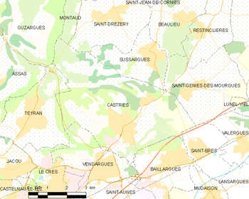
Map
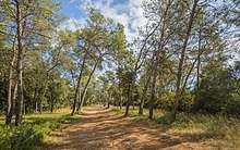
A wood called Les Pins

Aqueduc of Castries
Population
| Historical population | ||
|---|---|---|
| Year | Pop. | ±% |
| 1793 | 511 | — |
| 1800 | 558 | +9.2% |
| 1806 | 615 | +10.2% |
| 1821 | 787 | +28.0% |
| 1831 | 715 | −9.1% |
| 1836 | 798 | +11.6% |
| 1841 | 954 | +19.5% |
| 1846 | 1,017 | +6.6% |
| 1851 | 1,126 | +10.7% |
| 1856 | 1,150 | +2.1% |
| 1861 | 1,213 | +5.5% |
| 1866 | 1,386 | +14.3% |
| 1872 | 1,415 | +2.1% |
| 1876 | 1,212 | −14.3% |
| 1881 | 1,044 | −13.9% |
| 1886 | 1,080 | +3.4% |
| 1891 | 1,168 | +8.1% |
| 1896 | 1,280 | +9.6% |
| 1901 | 1,339 | +4.6% |
| 1906 | 1,336 | −0.2% |
| 1911 | 1,242 | −7.0% |
| 1921 | 1,368 | +10.1% |
| 1926 | 1,364 | −0.3% |
| 1931 | 1,430 | +4.8% |
| 1936 | 1,234 | −13.7% |
| 1946 | 1,090 | −11.7% |
| 1954 | 1,247 | +14.4% |
| 1962 | 1,368 | +9.7% |
| 1968 | 1,791 | +30.9% |
| 1975 | 2,461 | +37.4% |
| 1982 | 3,419 | +38.9% |
| 1990 | 3,992 | +16.8% |
| 1999 | 5,146 | +28.9% |
| 2008 | 5,519 | +7.2% |
Twin towns — sister cities
Castries is twinned with:

Sights
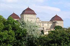
- Château de Castries. There is also a stone aqueduct which originally supplied water to the chateau.
See also
References
| Wikimedia Commons has media related to Castries (Hérault). |
This article is issued from
Wikipedia.
The text is licensed under Creative Commons - Attribution - Sharealike.
Additional terms may apply for the media files.