Buzignargues
| Buzignargues | ||
|---|---|---|
| Commune | ||
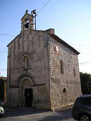 Saint-Nazaire-et-Saint-Celse church | ||
| ||
 Buzignargues Location within Occitanie region  Buzignargues | ||
| Coordinates: 43°46′16″N 4°00′20″E / 43.7711°N 4.0056°ECoordinates: 43°46′16″N 4°00′20″E / 43.7711°N 4.0056°E | ||
| Country | France | |
| Region | Occitanie | |
| Department | Hérault | |
| Arrondissement | Lodève | |
| Canton | Saint-Gély-du-Fesc | |
| Intercommunality | Ceps et Sylves | |
| Government | ||
| • Mayor (2008–2014) | Agnès Rouviere-Esposito | |
| Area1 | 4.61 km2 (1.78 sq mi) | |
| Population (2008)2 | 255 | |
| • Density | 55/km2 (140/sq mi) | |
| Time zone | UTC+1 (CET) | |
| • Summer (DST) | UTC+2 (CEST) | |
| INSEE/Postal code | 34043 /34160 | |
| Elevation |
40–133 m (131–436 ft) (avg. 70 m or 230 ft) | |
|
1 French Land Register data, which excludes lakes, ponds, glaciers > 1 km2 (0.386 sq mi or 247 acres) and river estuaries. 2 Population without double counting: residents of multiple communes (e.g., students and military personnel) only counted once. | ||
.svg.png)
Buzignargues is a commune in the Hérault department in southern France.
Population
| Historical population | ||
|---|---|---|
| Year | Pop. | ±% |
| 1962 | 101 | — |
| 1968 | 117 | +15.8% |
| 1975 | 124 | +6.0% |
| 1982 | 151 | +21.8% |
| 1990 | 160 | +6.0% |
| 1999 | 199 | +24.4% |
| 2008 | 255 | +28.1% |
Gallery
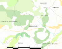
Municipal map

A detail of Saint-Nazaire-et-Saint-Celse church
See also
References
External links
| Wikimedia Commons has media related to Buzignargues. |
This article is issued from
Wikipedia.
The text is licensed under Creative Commons - Attribution - Sharealike.
Additional terms may apply for the media files.