Agonès
| Agonès | ||
|---|---|---|
| Commune | ||
| ||
 Agonès Location within Occitanie region  Agonès | ||
| Coordinates: 43°54′12″N 3°43′45″E / 43.9033°N 3.7292°ECoordinates: 43°54′12″N 3°43′45″E / 43.9033°N 3.7292°E | ||
| Country | France | |
| Region | Occitanie | |
| Department | Hérault | |
| Arrondissement | Lodève | |
| Canton | Lodève | |
| Intercommunality | Cévennes Gangeoises Suménoises | |
| Government | ||
| • Mayor (2014-2020) | Patrick Tricou | |
| Area1 | 4.16 km2 (1.61 sq mi) | |
| Population (2014)2 | 253 | |
| • Density | 61/km2 (160/sq mi) | |
| Time zone | UTC+1 (CET) | |
| • Summer (DST) | UTC+2 (CEST) | |
| INSEE/Postal code | 34005 /34190 | |
| Elevation |
119–323 m (390–1,060 ft) (avg. 150 m or 490 ft) | |
|
1 French Land Register data, which excludes lakes, ponds, glaciers > 1 km2 (0.386 sq mi or 247 acres) and river estuaries. 2 Population without double counting: residents of multiple communes (e.g., students and military personnel) only counted once. | ||
.svg.png)
Agonès is a commune in the Hérault department in the Occitanie region in southern France.
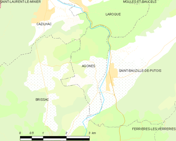
Map
Population
| Historical population | ||
|---|---|---|
| Year | Pop. | ±% |
| 1962 | 48 | — |
| 1968 | 68 | +41.7% |
| 1975 | 77 | +13.2% |
| 1982 | 99 | +28.6% |
| 1990 | 131 | +32.3% |
| 1999 | 179 | +36.6% |
| 2008 | 233 | +30.2% |
See also
References
| Wikimedia Commons has media related to Agonès. |
This article is issued from
Wikipedia.
The text is licensed under Creative Commons - Attribution - Sharealike.
Additional terms may apply for the media files.