Usclas-d'Hérault
| Usclas-d'Hérault | ||
|---|---|---|
| Commune | ||
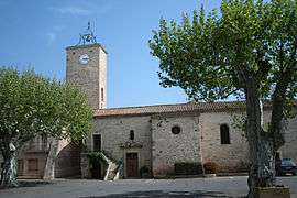 The church of Usclas-d'Hérault | ||
| ||
 Usclas-d'Hérault Location within Occitanie region  Usclas-d'Hérault | ||
| Coordinates: 43°31′10″N 3°27′54″E / 43.5194°N 3.465°ECoordinates: 43°31′10″N 3°27′54″E / 43.5194°N 3.465°E | ||
| Country | France | |
| Region | Occitanie | |
| Department | Hérault | |
| Arrondissement | Lodève | |
| Canton | Mèze | |
| Intercommunality | Clermontais | |
| Government | ||
| • Mayor (2008–2014) | Bernard Foulquier-Gazagnes | |
| Area1 | 2.82 km2 (1.09 sq mi) | |
| Population (2008)2 | 271 | |
| • Density | 96/km2 (250/sq mi) | |
| Time zone | UTC+1 (CET) | |
| • Summer (DST) | UTC+2 (CEST) | |
| INSEE/Postal code | 34315 /34230 | |
| Elevation |
18–30 m (59–98 ft) (avg. 24 m or 79 ft) | |
|
1 French Land Register data, which excludes lakes, ponds, glaciers > 1 km2 (0.386 sq mi or 247 acres) and river estuaries. 2 Population without double counting: residents of multiple communes (e.g., students and military personnel) only counted once. | ||
.svg.png)
Usclas-d'Hérault (Occitan: Usclats d'Erau) is a commune in the Hérault department in the Occitanie region in southern France.
Population
| Historical population | ||
|---|---|---|
| Year | Pop. | ±% |
| 1962 | 163 | — |
| 1968 | 166 | +1.8% |
| 1975 | 129 | −22.3% |
| 1982 | 134 | +3.9% |
| 1990 | 147 | +9.7% |
| 1999 | 144 | −2.0% |
| 2008 | 271 | +88.2% |
See also
References
| Wikimedia Commons has media related to Usclas-d'Hérault. |
This article is issued from
Wikipedia.
The text is licensed under Creative Commons - Attribution - Sharealike.
Additional terms may apply for the media files.