Windham, Connecticut
| Windham, Connecticut | ||
|---|---|---|
| Town | ||
 | ||
| ||
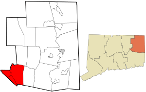 Location in Windham County and the state of Connecticut. | ||
| Coordinates: 41°43′N 72°10′W / 41.717°N 72.167°WCoordinates: 41°43′N 72°10′W / 41.717°N 72.167°W | ||
| Country | United States | |
| State | Connecticut | |
| NECTA | Willimantic | |
| Region | Windham Region | |
| Incorporated | 1693 | |
| Government | ||
| • Type | Town council | |
| • Mayor | Ernest S. Eldridge | |
| • Council president | N. Joseph Underwood | |
| Area | ||
| • Total | 27.9 sq mi (72.3 km2) | |
| • Land | 27.1 sq mi (70.1 km2) | |
| • Water | 0.9 sq mi (2.2 km2) | |
| Elevation | 233 ft (71 m) | |
| Population (2010)[1] | ||
| • Total | 25,268 | |
| • Density | 876/sq mi (339/km2) | |
| Time zone | UTC-5 (Eastern) | |
| • Summer (DST) | UTC-4 (Eastern) | |
| ZIP code | 06226, 06235, 06256, 06266, 06280 | |
| Area code(s) | 860 | |
| FIPS code | 09-86790 | |
| GNIS feature ID | 0213537 | |
| Website |
www | |

Windham is a town in Windham County, Connecticut, United States. It contains the former borough of Willimantic as well as the villages of Windham Center, North Windham, and South Windham. Willimantic, an incorporated city since 1893, was consolidated with the town in 1983. The population was 25,268 at the 2010 census.
History
The town of Windham was incorporated in 1693.[2]
Sites listed on the National Register of Historic Places
- Dr. Chester Hunt Office—Windham Center Road (added November 6, 1970)
- Forty-Seventh Camp of Rochambeau's Army (added February 23, 2003)
- Fourth Camp of Rochambeau's Army (added February 8, 2003)
- Main Street Historic District (Windham, Connecticut)—32, 50 and 54 North St. (added August 29, 1992)
- March Route of Rochambeau's Army: Scotland Road—Scotland Road, from intersection with Back Rd. to 80 Scotland Rd. (added July 6, 2003)
- Willimantic Armory—Pleasant Street (added October 12, 1985)
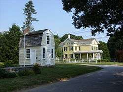
- Windham Center Historic District—state Routes 14 and 203 (added July 4, 1979)
Geography
According to the United States Census Bureau, the town has a total area of 27.9 square miles (72.3 km²), of which, 27.1 square miles (70.1 km²) of it is land and 0.9 square miles (2.2 km²) of it (3.04%) is water.
Climate
| Month | Jan | Feb | Mar | Apr | May | Jun | Jul | Aug | Sep | Oct | Nov | Dec | Year |
|---|---|---|---|---|---|---|---|---|---|---|---|---|---|
| Record high °F (°C) | 69 (21) |
72 (22) |
82 (28) |
93 (34) |
95 (35) |
98 (37) |
100 (38) |
100 (38) |
100 (38) |
88 (31) |
80 (27) |
75 (24) |
100 (38) |
| Average high °F (°C) | 35.3 (1.8) |
38.4 (3.6) |
47.3 (8.5) |
59.3 (15.2) |
70.1 (21.2) |
78.0 (25.6) |
82.3 (27.9) |
80.8 (27.1) |
73.8 (23.2) |
62.1 (16.7) |
51.9 (11.1) |
40.3 (4.6) |
60 (15.5) |
| Daily mean °F (°C) | 29.0 (−1.7) |
31.7 (−0.2) |
38.3 (3.5) |
48.1 (8.9) |
57.9 (14.4) |
67.7 (19.8) |
73.4 (23) |
72.1 (22.3) |
64.9 (18.3) |
54.0 (12.2) |
44.7 (7.1) |
34.7 (1.5) |
51.4 (10.8) |
| Average low °F (°C) | 17.0 (−8.3) |
19.6 (−6.9) |
26.3 (−3.2) |
36.2 (2.3) |
45.9 (7.7) |
55.5 (13.1) |
61.0 (16.1) |
59.9 (15.5) |
51.4 (10.8) |
39.6 (4.2) |
31.4 (−0.3) |
22.3 (−5.4) |
38.8 (3.8) |
| Record low °F (°C) | −27 (−33) |
−21 (−29) |
−16 (−27) |
6 (−14) |
22 (−6) |
30 (−1) |
37 (3) |
32 (0) |
20 (−7) |
15 (−9) |
1 (−17) |
−18 (−28) |
−27 (−33) |
| Average precipitation inches (mm) | 3.36 (85.3) |
3.25 (82.6) |
4.32 (109.7) |
3.74 (95) |
3.49 (88.6) |
3.68 (93.5) |
3.43 (87.1) |
3.35 (85.1) |
3.44 (87.4) |
3.94 (100.1) |
3.99 (101.3) |
3.78 (96) |
43.77 (1,111.7) |
| Average snowfall inches (cm) | 8.1 (20.6) |
11.1 (28.2) |
5.5 (14) |
1.1 (2.8) |
0.0 (0) |
0.0 (0) |
0.0 (0) |
0.0 (0) |
0.0 (0) |
0.0 (0) |
0.9 (2.3) |
6.7 (17) |
33.4 (84.9) |
| Average precipitation days (≥ 0.1 in) | 6 | 6 | 7 | 7 | 8 | 7 | 6 | 5 | 6 | 6 | 6 | 7 | 72 |
| Average snowy days (≥ 0.1 in.) | 4 | 4 | 3 | 0 | 0 | 0 | 0 | 0 | 0 | 0 | 1 | 2 | 15 |
| Source: [3] [4] | |||||||||||||
Demographics
| Historical population | |||
|---|---|---|---|
| Census | Pop. | %± | |
| 1820 | 2,489 | — | |
| 1840 | 3,382 | — | |
| 1850 | 4,503 | 33.1% | |
| 1860 | 4,243 | −5.8% | |
| 1870 | 5,412 | 27.6% | |
| 1880 | 8,264 | 52.7% | |
| 1890 | 10,032 | 21.4% | |
| 1900 | 8,937 | −10.9% | |
| 1910 | 12,604 | 41.0% | |
| 1920 | 13,801 | 9.5% | |
| 1930 | 13,773 | −0.2% | |
| 1940 | 13,824 | 0.4% | |
| 1950 | 15,884 | 14.9% | |
| 1960 | 16,973 | 6.9% | |
| 1970 | 19,626 | 15.6% | |
| 1980 | 21,062 | 7.3% | |
| 1990 | 22,039 | 4.6% | |
| 2000 | 22,857 | 3.7% | |
| 2010 | 25,268 | 10.5% | |
| Est. 2014 | 25,005 | [5] | −1.0% |
| U.S. Decennial Census[6] | |||
As of the census[7] of 2000, there were 22,857 people, 8,342 households, and 5,088 families residing in the town. The population density was 844.4 people per square mile (326.0/km²). There were 8,926 housing units at an average density of 329.8 per square mile (127.3/km²). The racial makeup of the town was 74.02% White, 5.06% African American, 0.56% Native American, 1.30% Asian, 0.12% Pacific Islander, 15.16% from other races, and 3.78% from two or more races. Hispanic or Latino of any race were 26.85% of the population.
There were 8,342 households out of which 30.1% had children under the age of 18 living with them, 39.4% were married couples living together, 16.8% had a female householder with no husband present, and 39.0% were non-families. 29.8% of all households were made up of individuals and 11.2% had someone living alone who was 65 years of age or older. The average household size was 2.47 and the average family size was 3.05.
In the town, the population was spread out with 23.0% under the age of 18, 18.1% from 18 to 24, 27.2% from 25 to 44, 19.1% from 45 to 64, and 12.6% who were 65 years of age or older. The median age was 31 years. For every 100 females, there were 93.5 males. For every 100 females age 18 and over, there were 90.0 males.
The median income for a household in the town was $35,087, and the median income for a family was $42,023. Males had a median income of $32,742 versus $25,703 for females. The per capita income for the town was $16,978. About 12.7% of families and 17.5% of the population were below the poverty line, including 23.9% of those under age 18 and 9.6% of those age 65 or over.
Education
Public Schools
- Windham Early Childhood Center
- Natchaug School
- North Windham School
- W.B. Sweeney School
- Windham Center School
- Windham Middle School
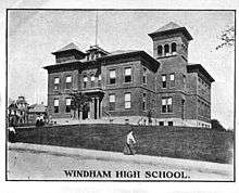
- Windham High School
- Windham Technical High School
Magnet Schools
- Charles H. Barrows STEM Academy
Private Schools
- St Mary-St Joseph School
Transportation
Route 32 runs through South Windham and north-western Willimantic. Route 66 goes east to west from North Windham to Columbia. Route 14 severs Willimantic to Windham Center. Route 203 severs the eastern section of town from North Windham to South Windham. Route 195 goes from Willimantic to Mansfield eventually going to the University of Connecticut. Route 289 starts in southern Willimantic and shortly after going into Lebanon to Route 87. US 6 bypasses the city and severs North Windham. Bus service is available around the town Monday thru Saturday. Airport service is from Windham Airport in North Windham. There is no passenger train service, but a freight train stop is found in Willimantic for the Providence and Worcester Railroad. Bus service is provided by the Northeastern Connecticut Transit District.
Notable people
- Eleazar Wheelock (1711–1779), a Congregational minister, orator, educator, and founder of Dartmouth College, was born in town.
- Eliphalet Dyer (1721–1807), a lawyer, jurist, and delegate for Connecticut to the Continental Congress, was born in town.
- William Hebard (1800–1875), a United States Representative from Vermont was born in town.
- George Hewitt Cushman (1814–1876), engraver and painter of miniature paintings and portraits.
- Samuel Huntington - Signed the Declaration of Independence and the Articles of Confederation; was 18th Governor of Connecticut.
- Benjamin Hanks (1755-1824), goldsmith, instrument maker, and first maker of bronze cannons and church bells in America.
- Gardiner Means (1896-1988), economist.
References
- ↑ U.S. Census Bureau Population Estimates
- ↑ "theChronicle.com". thechronicle.com. Retrieved 2018-10-13.
- ↑ "NOWData for Windham Airport". NOAA. Retrieved September 10, 2016.
- ↑ "Intellicast Willimantic, Connecticut Historical Averages". The Weather Company. Retrieved January 11, 2017.
- ↑ "Annual Estimates of the Resident Population for Incorporated Places: April 1, 2010 to July 1, 2014". Retrieved June 4, 2015.
- ↑ "Census of Population and Housing". Census.gov. Retrieved June 4, 2015.
- ↑ "American FactFinder". United States Census Bureau. Retrieved 2008-01-31.
External links
Places adjacent to Windham, Connecticut | |
|---|---|

Municipalities and communities of Windham County, Connecticut, United States | ||
|---|---|---|
| Towns |  | |
| Borough | ||
| Former cities | ||
| Other communities | ||