Windsor, Connecticut
| Windsor, Connecticut | ||
|---|---|---|
| Town | ||
| ||
| Motto(s): First in Connecticut, First for its Citizens | ||
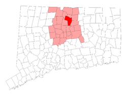 Location in Hartford County, Connecticut | ||
| Coordinates: 41°51′10″N 72°38′35″W / 41.85278°N 72.64306°WCoordinates: 41°51′10″N 72°38′35″W / 41.85278°N 72.64306°W | ||
| Country |
| |
| U.S. state |
| |
| County | Hartford | |
| NECTA | Hartford | |
| Region | Capitol Region | |
| Settled | September 26, 1633 | |
| Incorporated | 1637 | |
| Government | ||
| • Type | Council-manager[1] | |
| • Town manager | Peter Souza | |
| • Town council |
Donald S. Trinks (D), Mayor; Jody L. Terranova (D), Deputy Mayor; John J. Gamache (R); William H. Herzfeld (D); Donald A. Jepsen, Jr. (R); Kenny M. Wilkos (R); Randy McKenney (D); Alan J.Simon (D); Jim G. Govoni (R) | |
| Area | ||
| • Total | 31.0 sq mi (80.2 km2) | |
| • Land | 29.5 sq mi (76.4 km2) | |
| • Water | 1.5 sq mi (3.8 km2) | |
| Elevation | 55 ft (17.37 m) | |
| Population (2010) | ||
| • Total | 29,044 | |
| • Density | 940/sq mi (360/km2) | |
| Time zone | UTC-5 (Eastern) | |
| • Summer (DST) | UTC-4 (Eastern) | |
| ZIP code | 06095 | |
| Area Code | 860 | |
| FIPS code | 09-87000 | |
| GNIS feature ID | 0212354 | |
| Website |
www | |
| Elevation noted at Town Hall. | ||
Windsor is a town in Hartford County, Connecticut, United States, and was the first English settlement in the state. It lies on the northern border of Connecticut's capital, Hartford. The population of Windsor was 29,044 at the 2010 census.[2]
Poquonock /pəˈkwɒnək/ is a northern area of Windsor that has its own zip code (06064) for post-office box purposes.[3] Other unincorporated areas in Windsor include Rainbow and Hayden Station in the north, and Wilson and Deerfield in the south.
The Day Hill Road area is known as Windsor's Corporate Area, although other centers of business include New England Tradeport, Kennedy Industry Park and Kennedy Business Park, all near Bradley International Airport and the Addison Road Industrial Park.
History
The coastal areas and riverways were traditional areas of settlement by various American Indian cultures, who had been in the region for thousands of years. They relied on the rivers for fishing, water and transportation. Before European contact, the historic Pequot and Mohegan tribes had been one Algonquian-speaking people. After they separated, they became competitors and traditional enemies in the Connecticut region.
During the first part of the 17th century, the Pequot and Mohegan nations had been at war. The Podunk were forced to pay tribute to the more powerful Pequot, who claimed their land. Eventually, the Podunk invited a small party of settlers from Plymouth, Massachusetts, to settle as a mediating force between the other tribes. In exchange they granted them a plot of land at the confluence of the Farmington River and the west side of the Connecticut River. After Edward Winslow came from Plymouth to inspect the land, William Holmes led a small party, arriving at the site on September 26, 1633, where they founded a trading post.[4] The spot of the trading post is at the confluence of the Farmington and Connecticut Rivers. The Loomis Chaffee School currently owns the land as the spot is now the school's sports fields.
Native Americans referred to the area as Matianuck. It was about 50 miles (80 km) up river from Long Island Sound, at the end of waters navigable by ship and above the Dutch fort at Hartford, offering an advantageous location for the English to trade with the Indians before they reached the Dutch. (The Sicaog tribe had made a similar offer to mediate to the Dutch in New Amsterdam. New Netherland had far fewer European settlers than New England, and they were not in a position to take up the opportunity.)
In 1635, a party of around 30 people, sponsored by Sir Richard Saltonstall, and led by the Stiles brothers, Francis, John and Henry, settled in the Windsor area. Governor John Winthrop of the Massachusetts Bay Company acknowledged in a letter to Saltonstall that the Stiles party was the second group to settle Connecticut.
The first group of 60 or more people were led by Roger Ludlow, primary framer of the Fundamental Orders of Connecticut, having trekked overland from Dorchester, Massachusetts.[5] They had arrived in the New World five years earlier on the ship Mary and John from Plymouth, England, and settled in Dorchester.[6] Reverend Warham promptly renamed the Connecticut settlement "Dorchester". During the next few years, more settlers arrived from Dorchester, outnumbering and soon displacing the original Plymouth contingent, who returned to Plymouth in 1638 after selling their parcel to a Matthew Allyn of Hartford.[7]
In 1637, the colony's General Court changed the name of the settlement from Dorchester to Windsor,[8] named after the town of Windsor, Berkshire, on the River Thames in England.[9]
Several "daughter towns" were formed from Windsor's original boundaries. These include portions or all of Barkhamsted, Bloomfield, Bolton, Colebrook, Coventry, East Granby, East Windsor, Ellington, Enfield, Granby, Harwinton, Litchfield, Manchester, Morris, Simsbury, South Windsor, Suffield, Tolland, Torrington, Vernon, and Windsor Locks.[10]
The first "highway" in the Connecticut Colony opened in 1638 between Windsor and Hartford. Two years later, the highway was extended north to the colony's 1636 settlement at Springfield, with the road also connecting to Wethersfield and thus the four settlements that came to dominate the region for much of colonial history were connected.
In the summer of 1640, an event took place that would forever change the boundaries of the Connecticut River Valley. During a grain famine, the founder of Springfield, William Pynchon,[11] was given authority by Windsor and Hartford to negotiate a price for grain for the three settlements with the natives. First, the natives refused to sell grain at the usual market price, and then refused to sell it at "a reasonable price". Pynchon refused to buy it, attempting to teach the natives a peaceful lesson about integrity and reliability. Windsor's cattle were starving, however, and the citizens of Hartford were furious. With Windsor's consent, Hartford commissioned the famous Indian fighter John Mason to travel to Springfield with "money in one hand and a sword in the other" to threaten the natives, and thereby force the grain trade. The natives capitulated and ultimately sold their grain. After "negotiating the trade", Mason refused to share the grain with Springfield, and, to add further insult, insisted that Springfield pay a tax when sailing ships passed Windsor. Outraged, Springfield forever sided with the Massachusetts Bay Colony, a faraway theocracy based in Boston, rather than with the Connecticut Colony, which was much closer geographically and far more compatible ideologically. Windsor played a neutral role in the colonial rivalry between Hartford and Springfield; however, Windsor's direct border with both settlements caused many discussions about whether to align with Massachusetts or Connecticut. Ultimately, Windsor sided with Connecticut.[12][13]
The Hartford & Springfield Street Railway, a trolley, connected with the Connecticut Company in Windsor Center until 1925. Buses replaced trolleys between Rainbow (a northern section of Windsor) and Windsor Center in 1930. Trolley cars continued to run from Windsor to Hartford until 1940.[14]
The original Windsor settlers have many descendants around the country and beyond. Many are members of the Descendants of the Founders of Ancient Windsor (DFAW).
Historical points of interest
The Joseph Kesselring stage play and Frank Capra movie Arsenic and Old Lace was inspired by actual events that took place in a three-story brick house on Prospect Street, just off the north end of the Windsor green. Sixty men died between 1907 and 1917 while in the care of Amy Archer-Gilligan. Most were proven to be victims of arsenic poisoning.
On historic Palisado Avenue, one can find the First Church in Windsor, Congregational, and adjacent graveyard.[15]
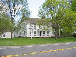
Across the street on the Palisado Green stands a statue of John Mason, a founder of Windsor and a colonial leader in the Pequot War. The historic plaque also honors Robert Seeley, Mason's second-in-command. Nearby stands Windsor's oldest structure, the Capt. John Fyler house, built in 1640.
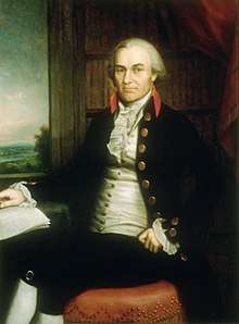
Further north is the home of Oliver Ellsworth, third Chief Justice of the United States.[16]
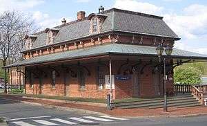
The town center is well-planned in comparison to many others in the Greater Hartford area. It has a relative diversity of chains and local shops, as well as a restored Amtrak train station dating to the 1850s. The Vintage Radio and Communications Museum of Connecticut is located in Windsor.[17]
From 1957 to 2006, the town was the location of the S1C Nuclear Powered Training Unit; a prototype nuclear power plant for the Naval Nuclear Propulsion Program. The former site has the distinction of being the first nuclear reactor site to receive unrestricted release after demolition and decontamination efforts.[18]
Other notable sites
%2C_Windsor%2C_CT_-_April_2016_(1).JPG)
Windsor is home to the following locations on the National Register of Historic Places:[20]
- Allyn, Capt. Benjamin, II, House - 119 Deerfield Rd. (added 1979)
- Giles Barber House - 411-413 Windsor Ave. (added 1988)
- Bissell Tavern-Bissell's Stage House - 1022 Palisado Ave. (added 1985)
- Broad Street Green Historic District - roughly along Broad St. from Batchelder Rd. to Union St. (added 1999)
- Benomi Case House - 436 Rainbow Rd. (added 1988)
- Hezekiah Chaffee House - Meadow Lane, off Palisado Green (added 1972)
- Taylor Chapman House - 407 Palisado Ave. (added 1988)
- Horace H. Ellsworth House - 316 Palisado Ave. (added 1988)
- George Loomis House - 1003 Windsor Avenue (added 1988)
- Gordon Loomis House - 1021 Windsor Avenue (added 1988)
- Ira Loomis, Jr. House - 1053 Windsor Avenue (added 1988)
- Capt. James Loomis House - 881 Windsor Avenue (added 1988)
- Capt. James Loomis House - 208-210 Broad Street (added 1988)
- Oliver Ellsworth Homestead - 778 Palisado Ave. (added 1970)[21]
- Farmington River Railroad Bridge - spans Farmington River and Pleasant St. west of Palisado Ave. (added 1972)
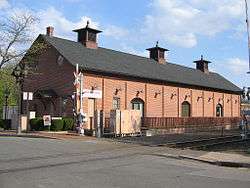
- Hartford & New Haven Railroad Depot - 41 Central St. (added 1988)
- Hartford & New Haven Railroad-Freight Depot - 40 Central St. (added 1988)
- Deacon John Moore House - 37 Elm St. (added 1977)
- Palisado Avenue Historic District - Palisado Ave. between the Farmington River and Bissell Ferry Rd. (added 1987)
Tobacco farming
Tobacco farming in Connecticut has a long history. When the first settlers came to the valley in the 1630s, tobacco was already being grown by the native population. By 1700 it was being exported via the Connecticut River to European ports. The use of Connecticut tobacco as a cigar wrapper leaf began in the 1820s.[22]
Area farmers grew tobacco for the two outside layers of cigars, the binder and the wrapper. Approximately 34,000 acres (140 km2) of land in Connecticut is covered by Windsor Soil, named after the town.[23]
The movie Parrish, starring Troy Donahue and Karl Malden, was set and filmed in the tobacco farms of Windsor. The film was released in 1961.
The Connecticut Valley Tobacco Museum,[24] containing authentic farming implements and tools, can be found at Northwest Park in Windsor.[25]
Education
The public schools in Windsor are a part of the Windsor Public Schools:
- One public school for pre-school and kindergarten: Roger Wolcott Early Childhood Center (No longer in operation after school consolidation, children now sent to in district schools, Poquonock or Ellsworth.)
- Four public elementary schools: Oliver Ellsworth Primary School, Clover Street Intermediate School, John F. Kennedy Intermediate School, and Poquonock Primary School. (Primary Schools: Grades K-2. Intermediate Schools: Grades 3-5)
- One public middle school (Grades 6–8): Sage Park Middle School
- One public high school (Grades 9–12): Windsor High School[26]
The magnet schools in Windsor are managed by the Capital Region Education Council:
- One magnet middle & high school (Grades 6–12): Academy of Aerospace and Engineering[27]
There are two public libraries: Windsor Public Library[28] and Wilson Public Library.
Loomis Chaffee, the well-known college preparatory school, is located in Windsor, on a 320-acre (130 ha) campus at the confluence of the Connecticut and Farmington rivers. The original Loomis Homestead, built by Joseph Loomis in 1640 and one of the oldest buildings in the United States, stands on the school's campus across the street from the current school head's residence.
Madina Academy, Connecticut's first full-time Islamic School, offers preschool through 12th grade [29]
Saint Gabriel's School is a private school that teaches kindergarten through eighth grade.[30] Trinity Christian School is a private school that teaches kindergarten through seventh grade.[31][32] Praise, Power, Prayer Christian School is a private school that teaches kindergarten through twelfth grade.[33][34]
Branford Hall Career Institute[35] and Baran Institute of Technology[36] are located on Day Hill Road.
Recreation and activities
Parks
Windsor Meadows State Park is in the southeast corner of town[37] and runs along the shore of the Connecticut River.
Keney Park, in the south, straddles Windsor and Hartford; it includes cricket fields and a golf course.[38]
Northwest Park, Windsor's largest park, is located in the northwest corner of Windsor. It includes a nature center, trails and an animal barn showcasing a burro, sheep, chickens, goats, rabbits, ducks, and a turkey.[39]
Welch Park is in the neighborhood of Poquonock on the Farmington River and is home to a public pool, a basketball court, numerous baseball diamonds, tennis courts, and a small playground.
Stroh Park is off Route 159 near Wilson Congregational Church towards the south end of town. It is home to a public pool, tennis courts, a playground, and a pond.
Strawberry Hills Park is located on River Street. It is a popular location in the summer months for those interested in canoeing and kayaking the Farmington River.
Mill Brook Open Space, the former Mill Brook and Traditions golf course headed to housing development was purchased and protected as open space by The Trust for Public Land in 2014.[40][41] This 95 acre property cost $2.1million dollars, with a $1,086,000 grant from the State of Connecticut to help preserve this open meadow.[42] This property will serve as "land for passive recreation, wildlife habitat, community character along with water quality & storm water protection purposes".[42] The proximity of the park to the town is also important in that it will put more than 1,200 residents within a 10-minute-walk to the property.[41]
Events
The Northwest Park Country Fair is held every fall.[43]
The Shad Derby Festival is held every spring in the town center.[44]
Entertainment
- Keney Park Golf Club[38]
- The Troy Donahue movie Parrish was filmed on Windsor's tobacco "plantations" in 1961.[45]
- The movie Academy Boyz was shot at Loomis Chaffee in 1997.[46]
- A scene in the movie War of the Worlds was shot along the Farmington River.[47]
Infrastructure
Religion
- Sanctuary of Faith and Glory Church
- Hopewell Baptist Church
- Truth & Freedom Ministry (Home Church)
- Pilgrim Way Baptist Church
- Grace Baptist Church
- Greater St. Paul's Baptist Church of Deliverance
- Saint Gabriel's Church, Roman Catholic
- Saint Gertrude's Church, Roman Catholic
- Saint Joseph's Church, Roman Catholic
- The First Church in Windsor, United Church of Christ
- Poquonock Community Church, Congregational
- Wilson Congregational Church, United Church of Christ
- Holy Zion Church of the Jubilee
- Mount Carmel Christian Ministries
- Faith Community Church
- Grace Episcopal Church
- Archer Memorial AME Zion Church
- Trinity United Methodist Church
- Christ the King Lutheran Church
- Congregation Beth Ahm, Jewish
- Oasis Christian Church of Connecticut
- Tohrah Judea
- Connecticut Valley Church of Christ
- Praise Power & Prayer Christian Temple
- Islamic Center of Connecticut
- International Gospel Fellowship
Transportation
- Windsor, Connecticut Amtrak station
- Bradley International Airport, which serves Greater Hartford as well as the greater Pioneer Valley, is located in the adjacent town of Windsor Locks to the north.
- Connecticut Transit: There are eight routes serving Windsor: 15, 30, 32, 34, 36, 40, 54, and 92.
- The 30-Bradley Flyer route bus runs between Hartford and Bradley International Airport through Windsor.
- The 32, 34, and 36 routes run between Windsor Center and Downtown Hartford along Windsor and Poquonock Avenues. While the 32 route terminates at the Poquonock Park & Ride Lot, the 34 route continues on to serve the Walgreens Distribution Center in the Rainbow neighborhood, and the 36 route continues on to connect with the 54 route in the Day Hill Road Corporate Area.
- The 92 route provides crosstown trips through Windsor beginning at Copaco in Bloomfield and ending at the Shoppes at Buckland Hills in Manchester.
- The 40-North Main Street-Wilson route terminates at the Wilson Park & Ride Lot.
- Service to the Poquonock Park & Ride Lot is provided by the local 30, 32, 34, 36, and 54 routes as well as the 15-Windsor Express route, which provides express service between Poquonock Avenue and Downtown Hartford via I-91.[48]
- Interstate 91 has 7 exits in Windsor, including a High Occupancy Vehicle (HOV) lane traveling north and south between Hartford and the Bradley Airport Connector (Route 20).
- Interstate 291 (Connecticut) begins in Windsor with 3 exits; it connects Interstate 91 with Interstate 84.
- A rail line runs parallel to the Connecticut River through Windsor, with one stop for Amtrak trains in Windsor center. There were also stations at Wilson in the south of town and Hayden in the north, both named for landowners who provided land for the railroad right of way. The line was double tracked until the late 1990s. Sidings at Windsor station allowed cars to be spotted at the freight house and on the Loomis trestle just to the south. The trestle was removed in the late 1980s. An 1856 brownstone arch bridge carries the tracks over Pleasant St and the Farmington River. Incorporating a horizontal curve, its engineering was noteworthy when built. Following a fatal grade crossing accident, a three-track-wide plate girder bridge was installed to carry tracks over Palisado Ave in Windsor center.
- Senior Transportation services are available to Dial-A-Ride patrons (adults 60 and over and those receiving Social Security Disability benefits) and Windsor's Caring Connection Adult Day Health Center clients. Senior Transportation utilizes specially equipped vans operated by experienced drivers and provides approximately 28,000 trips per year. See reference link for more information. <http://www.townofwindsorct.com/transportation/index.php?page=95>
Public safety
- Windsor Police Department is located at the Windsor Safety Complex, in the middle of town, next to I-91, on Bloomfield Avenue.[49]
- Windsor Volunteer Fire Department has 5 stations: Windsor Station (at the Windsor Safety Complex), Wilson Station, Poquonock Station, Rainbow Road Station and Hayden Station.[50]
- Windsor Volunteer Ambulance is also located at the Windsor Safety Complex.[51]
Economy
Top employers
According to Windsor's 2011 Comprehensive Annual Financial Report,[52] the top employers in the city were:
| # | Employer | # of Employees |
|---|---|---|
| 1 | The Hartford | 2,100 |
| 2 | Voya | 1,835 |
| 3 | General Electric (Formerly Alstom) | 1,000 |
| 4 | Cigna | 900 |
| 5 | Town of Windsor | 809 |
| 6 | Westinghouse Electric Company | 700 |
| 7 | Northeast Utilities | 600 |
| 8 | Walgreens | 530 |
| 9 | Konica Minolta | 450 |
| 10 | Permasteelisa | 400 |
| 11 | SS&C Technologies | 350 |
| 12 | Sun Life Financial | 350 |
| 13 | Valassis | 350 |
| 14 | Bank of America | 300 |
Notable people
- Al Anderson, guitarist, singer and songwriter, best known for his 20-year stint in NRBQ[53]
- Moe Drabowsky (1935-2006), Polish-born Major League Baseball pitcher, raised in Wilson, schooled at Loomis
- Oliver Ellsworth, third Chief Justice of the United States, a drafter of the Constitution and American founding father, was born in Windsor
- Roger Enos, veteran of the French and Indian War and American Revolution who commanded the Vermont Militia in the later stages of the American Revolution
- John Fitch, the inventor of the steamboat
- General William Hayden, Connecticut Adjutant General 1835 - 1836
- Mike Joy (b. 1949), TV sports announcer who serves as the lap-by-lap voice of FOX Sports' NASCAR coverage, served four elected terms on the Windsor Town Council
- Evelyn Beatrice Longman, first woman sculptor to be elected a full member of the National Academy of Design[54]
- Lancelot Phelps, (1784–1866), congressman from Connecticut
- William Phelps (1599 – 1672), woodworker, judge, civil servant
- Joseph Hayne Rainey (June 21, 1832 – August 1, 1887), first African American to be elected to Congress, US congressman from South Carolina, lived in a summer house here with his family
- Iceman John Scully, professional boxer, world title challenger, ESPN Classic boxing broadcaster
- Oliver Wolcott, American founding father, born in Windsor
- Roger Wolcott (1679–1767), weaver, colonial governor of Connecticut (1751–54), father of Oliver Wolcott
Geography

Windsor's highest point is on Day Hill at 230 feet (70 m) above sea level.[55] Windsor's lowest point is on the Connecticut River at 5 feet (1.5 m) above sea level.
[55] The Connecticut River defines Windsor's east border. The city of Hartford, the capital of Connecticut, is adjacent to Windsor to the south. The town of Windsor Locks, home of Bradley International Airport, is adjacent to Windsor to the north. Prior to its incorporation in 1854, it was known as the Pine Meadow section of Windsor. The towns of East Windsor and South Windsor are on the east side of the Connecticut River. The town of Bloomfield is to the west. The town of East Granby is to the northwest.
The Farmington River joins the Connecticut River in Windsor. The Farmington River is dammed in the northwest corner of Windsor to form the 234-acre (0.95 km2) Rainbow Reservoir.[56]
Principal communities
- Deerfield
- Hayden Station
- Poquonock
- Rainbow
- Wilson
- Windsor Center
Demographics
| Historical population | |||
|---|---|---|---|
| Census | Pop. | %± | |
| 1820 | 3,008 | — | |
| 1850 | 3,294 | — | |
| 1860 | 2,278 | −30.8% | |
| 1870 | 2,783 | 22.2% | |
| 1880 | 3,058 | 9.9% | |
| 1890 | 2,954 | −3.4% | |
| 1900 | 3,614 | 22.3% | |
| 1910 | 4,178 | 15.6% | |
| 1920 | 5,620 | 34.5% | |
| 1930 | 8,290 | 47.5% | |
| 1940 | 10,068 | 21.4% | |
| 1950 | 11,833 | 17.5% | |
| 1960 | 19,467 | 64.5% | |
| 1970 | 22,502 | 15.6% | |
| 1980 | 25,204 | 12.0% | |
| 1990 | 27,817 | 10.4% | |
| 2000 | 28,237 | 1.5% | |
| 2010 | 29,044 | 2.9% | |
| Est. 2014 | 29,069 | [57] | 0.1% |
| U.S. Decennial Census[58] | |||
Population
| Year | Population |
|---|---|
| 1850 | 3,294 |
| 1900 | 3,614 |
| 1950 | 11,833 |
| 2000 | 28,237 [59] |
| 2010 | 29,044 |
As of the census of 2010, there were 29,044 people, 11,233 households, and 7,881 families residing in the town. The population density was 984.5 persons per square mile (380.2/km²). There were 11,767 housing units at an average density of 398.9 per square mile (154.0/km²). The racial makeup of the town was 54.7% White, 34.3% African American, 0.2% Native American, 4.5% Asian, 0.01% Pacific Islander, 3.1% some other race, and 3.2% from two or more races. Hispanic or Latino of any race were 8.4% of the population.[60]
There were 11,233 households, out of which 28.1% had children under the age of 18 living with them, 50.9% were headed by married couples living together, 14.9% had a female householder with no husband present, and 29.8% were non-families. 24.1% of all households were made up of individuals, and 8.8% were someone living alone who was 65 years of age or older. The average household size was 2.54 and the average family size was 3.04.[60]
In the town, the population was spread out with 21.5% under the age of 18, 7.4% from 18 to 24, 23.9% from 25 to 44, 31.8% from 45 to 64, and 15.3% who were 65 years of age or older. The median age was 43.1 years. For every 100 females, there were 90.9 males. For every 100 females age 18 and over, there were 87.8 males.[60]
Income
According to the U.S. Census Bureau's American Community Survey, for the period 2009-2011, median income for a household in the town was $78,211, and median income for a family was $89,726. Male full-time year-round workers had a median income of $58,668 versus $50,529 for females. The per capita income for the town was $34,899. About 3.1% of families and 4.5% of the population were below the poverty line, including 6.0% of those under age 18 and 4.8% of those age 65 or over.[61]
Windsor was one of a handful of towns in the country where, in the 2000 United States Census, median income for black households ($64,159) was larger than white households ($63,624). Asian households had a median income of $75,716. Hispanic or Latino (of any race) households have a median income of $69,808.[62]
High school demographics
Windsor High School has 1,471 students enrolled. Demographics for 2004–2005 were:
- Black 46.2%
- White 41.1%
- Hispanic 8.8%
- Asian 3.8%
- Native American 0.1%[63]
Politics
Connecticut House of Representatives:
United States House of Representatives:
| Voter registration and party enrolment as of October 26, 2010[71] | ||||
|---|---|---|---|---|
| Party | Active voters | Inactive voters | Total voters | |
| Democratic | 9,431 | 342 | 9,773 | |
| Republican | 2,861 | 149 | 3,010 | |
| Unaffiliated | 7,443 | 450 | 7,893 | |
| Minor Parties | 54 | 1 | 55 | |
| Total | 19,789 | 942 | 20,731 | |
Minor party registrations in Windsor include Green, Libertarian, and Working Families.
See also
References
- ↑ "Town Council". Townofwindsorct.com. Archived from the original on 2010-12-09. Retrieved 2009-10-12.
- ↑ "Geographic Identifiers: 2010 Demographic Profile Data (G001): Windsor town, Hartford County, Connecticut". U.S. Census Bureau, American Factfinder. Retrieved November 28, 2012.
- ↑ "USPS – ZIP Code Lookup – Search By City". Zip4.usps.com. 2008-11-26. Archived from the original on 2010-11-22. Retrieved 2009-10-12.
- ↑ Van Dusen, Albert "Connecticut" Random House, 1961, pp 19-20
- ↑ The History of Ancient Windsor, Connecticut: Including East Windsor, South Windsor, and Windsor Locks by Henry Reed Stiles, pages 17 through 29
- ↑ Thistlewaite, Frank: Dorset Pilgrims
- ↑ The History of Ancient Windsor, Connecticut: Including East Windsor, South Windsor, and Windsor Locks by Henry Reed Stiles, page 43
- ↑ "Public Records of the Colony of Connecticut, Volume 1, Page 7". Colonialct.uconn.edu. 2001-02-01. Retrieved 2009-10-12.
- ↑ The Connecticut Magazine: An Illustrated Monthly. Connecticut Magazine Company. 1903. p. 335.
- ↑ "Windsor History". Windsor Historical Society. Retrieved September 5, 2018.
- ↑ http://www.bio.umass.edu/biology/conn.river/pynchon.html
- ↑ http://history.rays-place.com/ct/Windsor.pdf
- ↑ The History of Springfield in Massachusetts for the Young: Being Also in ... - Charles Henry Barrows - Google Books. Books.google.com. Retrieved on 2013-07-15.
- ↑ "Trolley Towns CT: Windsor". Bera.org. Archived from the original on 2010-12-09. Retrieved 2009-10-12.
- ↑ "Frontpage". The First Church in Windsor. Archived from the original on 2010-12-09. Retrieved 2009-10-12.
- ↑ John F. Kennedy. "Oliver Ellsworth (chief justice of United States) – Britannica Online Encyclopedia". Britannica.com. Archived from the original on 2010-12-09. Retrieved 2009-10-12.
- ↑ "Welcome to the Vintage Radio and Communications Museum of Connecticut!". Vrcmct.org. Archived from the original on 2010-12-09. Retrieved 2009-10-12.
- ↑ "DOE Reactor Site Returns To Green Field Conditions". National Nuclear Security Administration.
- ↑ Pelland, Dave. "War Memorial, Windsor". CT Monuments.net (Connecticut History in Granite and Bronze). Retrieved 23 April 2016.
- ↑ National Park Service (2010-07-09). "National Register Information System". National Register of Historic Places. National Park Service.
- ↑ Archived August 10, 2007, at the Wayback Machine.
- ↑ "Wrapped Up" (Winter 1992). Cigar Aficionado. 1992-12-01. Archived from the original on 2010-12-09. Retrieved 2009-10-12.
- ↑ "CT Soils – Windsor | Connecticut NRCS". Ct.nrcs.usda.gov. Archived from the original on 2007-07-31. Retrieved 2009-10-12.
- ↑ "Connecticut Valley Tobacco Historical Society". Tobaccohistsoc.org. Archived from the original on 2010-12-09. Retrieved 2009-10-12.
- ↑ "Friends of Northwest Park". Northwestpark.org. Archived from the original on 2010-12-09. Retrieved 2009-10-12.
- ↑ "Windsor Public Schools". Windsorct.org. Archived from the original on 2010-12-09. Retrieved 2009-10-12.
- ↑ "CREC Schools | Theme-Based Academies". www.crecschools.org. Retrieved 2017-04-25.
- ↑ "Windsor Public Library, Windsor Connecticut". Windsorlibrary.com. Retrieved 2009-10-12.
- ↑ "Madina Academy".
- ↑ Saint Gabriel School of Windsor Connecticut. "Saint Gabriel School of Windsor Connecticut". Stgabrielschool.org. Archived from the original on 2010-12-09. Retrieved 2009-10-12.
- ↑ "Trinity Christian School – Windsor, Connecticut". Schools.privateschoolsreport.com. Archived from the original on 2010-12-09. Retrieved 2009-10-12.
- ↑ "Trinity Christian School – Windsor, Connecticut/CT – Private School Profile". Privateschoolreview.com. Archived from the original on 2010-12-09. Retrieved 2009-10-12.
- ↑ "Praise,Power,-Prayer Christian School – Windsor, Connecticut". Schools.privateschoolsreport.com. Archived from the original on 2010-12-09. Retrieved 2009-10-12.
- ↑ "Praise, Power & Prayer Christian – Windsor, Connecticut – CT – School overview". Greatschools.net. Archived from the original on 2010-12-09. Retrieved 2009-10-12.
- ↑ "Branford Hall Career Institute » Technical Schools | Windsor Connecticut". Branfordhall.com. Archived from the original on 2010-12-09. Retrieved 2009-10-12.
- ↑ "Lincoln Technical Institute – Official Web Site". Baraninstitute.com. Archived from the original on 2010-12-09. Retrieved 2009-10-12.
- ↑ "Connecticut State Parks". StateParks.com. Archived from the original on 2010-12-09. Retrieved 2009-10-12.
- 1 2 Kevin McCarthy, Principal Analyst (2005-03-14). "Keney Park and PILOTs". Cga.ct.gov. Archived from the original on 2010-12-09. Retrieved 2009-10-12.
- ↑ "Welcome to Northwest Park". Northwestpark.org. 2009-09-08. Archived from the original on 2010-12-09. Retrieved 2009-10-12.
- ↑ Goode, Steven. "Former Golf Course In Windsor Headed For Open Space Acquisition". Courant Community. Retrieved 2018-08-10.
- 1 2 "Mill Brook Open Space". The Trust for Public Land. Retrieved 2018-08-10.
- 1 2 "Mill Brook Open Space Steering Committee Public Input Opportunity!". townofwindsorct.com. Retrieved 2018-08-10.
- ↑ "Friends of Northwest Park Events". Northwestpark.org. 2009-09-26. Archived from the original on 2010-12-09. Retrieved 2009-10-12.
- ↑ "Windsor CT Shad Derby". Windsorshadderby.org. Archived from the original on 2010-12-09. Retrieved 2009-10-12.
- ↑ Parrish (1961)
- ↑ Academy Boyz (1997)
- ↑ War of the Worlds (2005)
- ↑ Archived December 16, 2006, at the Wayback Machine.
- ↑ "Windsor Police Department". Windsorpolice.com. Archived from the original on 2010-12-09. Retrieved 2009-10-12.
- ↑ "Windsorfiredept.com". Windsorfiredept.com. Archived from the original on 2010-12-09. Retrieved 2009-10-12.
- ↑ "Windsor Volunteer Ambulance". www.windsorctems.com. Archived from the original on 2010-12-09. Retrieved 2009-10-12.
- ↑ Department of Financial Accounting & Reporting (30 June 2011). Comprehensive Annual Financial Report (PDF) (Report). Town of Windsor, Connecticut. p. 111. Retrieved 21 April 2015.
- ↑ Dixon, Ken, "Music Hall of Fame proposed for state", article in Connecticut Post in Bridgeport, Connecticut, April 26, 2007 ("Al Anderson, longtime guitarist/songwriter for the rock band NRBQ [...] Anderson, who grew up in Windsor")
- ↑ "Evelyn Longman Batchelder". Connecticut Women's Hall of Fame. Retrieved May 22, 2014.
- 1 2 "USGS Hartford North (CT,MA) Topo Map". TopoZone. Archived from the original on 2010-12-09. Retrieved 2009-10-12.
- ↑ "Rainbow Reservoir – CT". Paddling.net. Archived from the original on 2010-12-09. Retrieved 2009-10-12.
- ↑ "Annual Estimates of the Resident Population for Incorporated Places: April 1, 2010 to July 1, 2014". Retrieved June 4, 2015.
- ↑ "Census of Population and Housing". Census.gov. Retrieved June 4, 2015.
- ↑ "Untitled Document". clear.uconn.edu.
- 1 2 3 "Profile of General Population and Housing Characteristics: 2010 Demographic Profile Data (DP-1): Windsor town, Hartford County, Connecticut". U.S. Census Bureau, American Factfinder. Retrieved November 29, 2012.
- ↑ "Selected Economic Characteristics: 2009-2011 American Community Survey 3-Year Estimates (DP03): Windsor town, Hartford County, Connecticut". U.S. Census Bureau, American Factfinder. Retrieved November 29, 2012.
- ↑ "town, Hartford County, Connecticut – Select a Race, Ethnic, or Ancestry Group – American FactFinder". Factfinder.census.gov. Retrieved 2009-10-12.
- ↑ "164-61" (PDF). Archived from the original on 2010-06-04. Retrieved 2009-10-12.
- ↑ "State Representative David A. Baram – Redirect".
- ↑ "State Representative Elaine C. O Brien – Redirect".
- ↑ "Rep. Peggy Sayers". Cga.ct.gov. Archived from the original on June 26, 2008. Retrieved 2009-10-12.
- ↑ Archived December 18, 2014, at the Wayback Machine.
- ↑ "Connecticut State Senator Eric Coleman". Senatedems.state.ct.us. Archived from the original on 2010-12-09. Retrieved 2009-10-12.
- ↑ "Connecticut State Senator John Kissel".
- ↑ "The Online Office of Congressman John B. Larson". House.gov. Archived from the original on 2010-12-09. Retrieved 2009-10-12.
- ↑ "Registration and Party Enrollment Statistics as of October 26, 2010" (PDF). Connecticut Secretary of State. Retrieved 2011-02-15.
Further reading
External links
| Wikivoyage has a travel guide for Windsor. |
| Wikimedia Commons has media related to Windsor, Connecticut. |
- Town of Windsor official website
- Windsor Historical Society
- WindsorLocksHistory.com - articles, books, videos and maps on the history of Windsor Locks
- Windsor Chamber of Commerce
- First Town Downtown
Places adjacent to Windsor, Connecticut | |
|---|---|
Municipalities and communities of Hartford County, Connecticut, United States | ||
|---|---|---|
| Cities | 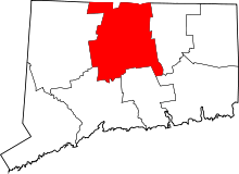 | |
| Towns | ||
| CDPs | ||
| Other communities | ||