Griswold, Connecticut
| Griswold, Connecticut | ||
|---|---|---|
| Town | ||
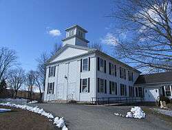 First Congregational Church | ||
| ||
 Location within New London County, Connecticut | ||
| Coordinates: 41°35′04″N 71°55′16″W / 41.58444°N 71.92111°WCoordinates: 41°35′04″N 71°55′16″W / 41.58444°N 71.92111°W | ||
| Country | United States | |
| State | Connecticut | |
| NECTA | Norwich-New London | |
| Region | Southeastern Connecticut | |
| Incorporated | 1815 | |
| Government | ||
| • Type | Selectman-town meeting | |
| • First selectman | Todd Babbitt | |
| Area | ||
| • Total | 37.1 sq mi (96.0 km2) | |
| • Land | 34.7 sq mi (89.9 km2) | |
| • Water | 2.4 sq mi (6.1 km2) | |
| Elevation | 210 ft (64 m) | |
| Population (2010) | ||
| • Total | 11,951 | |
| • Density | 320/sq mi (120/km2) | |
| Time zone | UTC-5 (Eastern) | |
| • Summer (DST) | UTC-4 (Eastern) | |
| ZIP code | 06351 | |
| Area code(s) | 860 | |
| FIPS code | 09-33900 | |
| GNIS feature ID | 0213436 | |
| Website |
www | |
Griswold is a town in New London County, Connecticut, United States. The population was 11,951 at the 2010 census.[1] Griswold contains one borough, Jewett City, and also contains the villages of Doaneville, Rixtown, Glasgo, Hopeville, and Pachaug.
History
Long a fishing ground for the Mohegan people, the waterways attracted settlers who established ironworks, saw and corn mills, and other businesses.
The town of Griswold was originally the "northern" part of the town of Preston. As the local population grew, at the request of residents who had been travelling to Preston for church functions, the North Society was established in 1716.[2][3]
In the late 1700s, Eliezer Jewett opened several mills and an irrigation plant. His success led the area to be called Jewett City.[4] The town of Griswold incorporated in 1815, naming itself after Governor Roger Griswold.[5][6] In 1895, Jewett City incorporated as a borough of the town. Griswold contains Hopeville Pond State Park, former site of a woolen mill.[4]
Geography
The Pachaug and Quinebaug rivers flow through the town of Griswold, which is located at the northeastern edge of New London County.[4] According to the United States Census Bureau, the town has a total area of 37.1 square miles (96.0 km2), of which 34.7 square miles (89.9 km2) is land and 2.4 square miles (6.1 km2), or 6.37%, is water.[7]
Demographics
| Historical population | |||
|---|---|---|---|
| Census | Pop. | %± | |
| 1820 | 1,859 | — | |
| 1850 | 2,065 | — | |
| 1860 | 2,217 | 7.4% | |
| 1870 | 2,575 | 16.1% | |
| 1880 | 2,745 | 6.6% | |
| 1890 | 3,113 | 13.4% | |
| 1900 | 3,490 | 12.1% | |
| 1910 | 4,233 | 21.3% | |
| 1920 | 4,220 | −0.3% | |
| 1930 | 6,010 | 42.4% | |
| 1940 | 5,343 | −11.1% | |
| 1950 | 5,728 | 7.2% | |
| 1960 | 6,472 | 13.0% | |
| 1970 | 7,763 | 19.9% | |
| 1980 | 8,967 | 15.5% | |
| 1990 | 10,384 | 15.8% | |
| 2000 | 10,807 | 4.1% | |
| 2010 | 11,951 | 10.6% | |
| Est. 2014 | 11,916 | [8] | −0.3% |
| [1][9] | |||
As of the census[10] of 2010, there were 11,951 people, 4,646 households, and 3,225 families residing in the town. The population density was 344.4 people per square mile (132.9/km²). There were 5,118 housing units at an average density of 147.5 per square mile (56.9/km²). The racial makeup of the town was 91.6% White, 1.8% African American, 0.9% Native American, 2.2% Asian, 0.03% Pacific Islander, 0.6% some other race, and 2.8% from two or more races. Hispanic or Latino of any race were 3.3% of the population.[1]
There were 4,646 households, out of which 31.3% had children under the age of 18 living with them, 50.3% were headed by married couples living together, 12.5% had a female householder with no husband present, and 30.6% were non-families. 23.3% of all households were made up of individuals, and 7.4% were someone living alone who was 65 years of age or older. The average household size was 2.57 and the average family size was 3.00.[1]
In the town, the population was spread out with 22.9% under the age of 18, 8.4% from 18 to 24, 27.2% from 25 to 44, 30.8% from 45 to 64, and 10.7% who were 65 years of age or older. The median age was 39.6 years. For every 100 females, there were 99.8 males. For every 100 females age 18 and over, there were 97.8 males.[1]
At the 2000 census, the median income for a household in the town was $40,156, and the median income for a family was $48,852. Males had a median income of $57,869 versus $17,441 for females. The per capita income for the town was $21,196. About 6.1% of families and 9.2% of the population were below the poverty line, including 6.1% of those under age 18 and 7.6% of those age 65 or over.
| Voter Registration and Party Enrollment as of October 30, 2014[11] | |||||
|---|---|---|---|---|---|
| Party | Active Voters | Inactive Voters | Total Voters | Percentage | |
| Democratic | 2,161 | 116 | 2,277 | 31.4% | |
| Republican | 1,314 | 33 | 1,347 | 19.6% | |
| Unaffiliated | 2,946 | 197 | 3,143 | 45.6% | |
| Minor Parties | 115 | 5 | 120 | 1.7% | |
| Total | 6,536 | 351 | 6,887 | 100% | |
Notable locations
- Ashland Mill Bridge - a bridge over the Pachaug River built in 1886 and on the National Register of Historic Places since 1999.
- Avery House - built in 1770, it was added to the National Register of Historic Places in 1986.
- Edward Cogswell House - added to the National Register of Historic Places in 1993.
- Kinne Cemetery - on Jarvis Road, it has been in use since 1713 and was added to the National Register of Historic Places in 2001.
- Timothy Lester Farmstead - built in 1741 and added to the National Register of Historic Places in 1998.
- Slater Library and Fanning Annex - 26 Main Street in Jewett City, built in 1884 and added to the National Register of Historic Places in 2002.
Notable people
- Clifford Chapin (born 1988), American voice actor affiliated with Funimation born in Griswold
- John Cantius Garand (1888–1974), Canadian-American designer of firearms best known for creating the first successful semi-automatic rifle to be widely used in active military service, the M1 Garand. The Interstate 395 bridge that crosses the Quinebaug River on the Griswold/Lisbon town line is named in his honor.
- Moses Coit Tyler (1835–1900), author born in Griswold
References
- 1 2 3 4 5 "Profile of General Population and Housing Characteristics: 2010 Demographic Profile Data (DP-1): Griswold town, New London County, Connecticut". U.S. Census Bureau, American Factfinder. Archived from the original on September 11, 2013. Retrieved October 25, 2012.
- ↑ Connecticut Colony Public Records, Vol. IV
- ↑ Preston. First Congregational Church. The Bicentennial Celebration
- 1 2 3 Connecticut History: Griswold, accessed 5 Nov 2017.
- ↑ The Connecticut Magazine: An Illustrated Monthly. Connecticut Magazine Company. 1903. p. 332.
- ↑ Gannett, Henry (1905). The Origin of Certain Place Names in the United States. Govt. Print. Off. p. 145.
- ↑ "Geographic Identifiers: 2010 Demographic Profile Data (G001): Griswold town, New London County, Connecticut". U.S. Census Bureau, American Factfinder. Archived from the original on September 11, 2013. Retrieved October 24, 2012.
- ↑ "Annual Estimates of the Resident Population for Incorporated Places: April 1, 2010 to July 1, 2014". Archived from the original on May 23, 2015. Retrieved June 4, 2015.
- ↑ U.S. Census Bureau. Accessed October 14, 2009.
- ↑ "American FactFinder". United States Census Bureau. Archived from the original on 2013-09-11. Retrieved 2008-01-31.
- ↑ "Registration and Party Enrollment Statistics as of October 30, 2014" (PDF). Connecticut Secretary of State. Retrieved 2015-05-08.
External links
Municipalities and communities of New London County, Connecticut, United States | ||
|---|---|---|
| Cities | 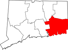 | |
| Towns | ||
| Boroughs | ||
| CDPs | ||
| Other communities | ||
| Indian reservations | ||
| Footnotes | ‡This populated place also has portions in an adjacent county or counties | |