Putnam, Connecticut
| Putnam, Connecticut | ||
|---|---|---|
| Town | ||
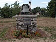
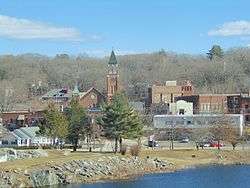 The center of Putnam | ||
| ||
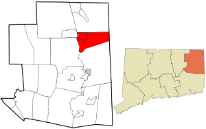 Location in Windham County and the state of Connecticut. | ||
| Coordinates: 41°54′22″N 71°52′13″W / 41.90611°N 71.87028°WCoordinates: 41°54′22″N 71°52′13″W / 41.90611°N 71.87028°W | ||
| Country |
| |
| State |
| |
| County | Windham | |
| NECTA | Worcester, MA | |
| Region | Northeastern Connecticut | |
| Incorporated | 1855 | |
| Government | ||
| • Type | Selectman-Town Meeting | |
| • Mayor | Barney Seney (R) | |
| • Board of Selectmen |
Roy Simmons (R), Deputy Mayor Rick Hayes (R) Scott Pempek (D) Jeffrey Rawson (R) Donald Steinbrick (R) Owen Tarr (D) | |
| • State Senator |
Mae Flexer (D-29th District) | |
| • State Rep. |
Daniel Rovero (D-51st District) | |
| Area | ||
| • Total | 20.4 sq mi (52.8 km2) | |
| • Land | 20.3 sq mi (52.6 km2) | |
| • Water | 0.1 sq mi (0.3 km2) | |
| Elevation | 410 ft (125 m) | |
| Population (2010) | ||
| • Total | 9,584 | |
| • Density | 472/sq mi (182/km2) | |
| Time zone | UTC−5 (Eastern) | |
| • Summer (DST) | UTC−4 (Eastern) | |
| ZIP code | 06260 | |
| Area code(s) | 860 | |
| FIPS code | 09-62710 | |
| GNIS feature ID | 0213494 | |
| Website | http://www.putnamct.us/ | |
Putnam is a town in Windham County, Connecticut, United States. The population was 9,584 at the 2010 census. It is home to WINY, an AM radio station.
History

Putnam, originally known as Aspinock, then part of Killingly, is a New England mill town incorporated in 1855. Created from sections of Killingly, Pomfret, and Thompson, the town was named in honor of Revolutionary War General Israel Putnam.[1]
Putnam was a key contributor in providing clothing and other goods to the Civil War soldiers. There were numerous mills and a train ran through the town, providing transportation for the goods being produced.
On August 19, 1955, Putnam was devastated by floods from torrential downpours caused by two hurricanes, which hit Connecticut within the span of a week. Hurricane Connie affected Connecticut on August 13, dropping between four and six inches (152 mm) of rain across the state. Hurricane Diane soaked the state with 14 inches (360 mm) of rain on August 18–19. The result was flooding in many of the state's rivers, including the Quinebaug River. The resulting torrent of water destroyed homes, businesses and factories. Floating magnesium barrels burst, lighting up the night. The railroad bed was washed away.
Toward the end of the twentieth century, the town took advantage of the empty mills and underutilized downtown commercial buildings to develop a large antique center. Antique shops line Main Street and other areas in town.
Putnam was also the unlikely base of operations for the All-Russian Fascist Organization, a pre-war Russian emigre group that advocated fascism for the country under Anastasy Vonsyatsky.[2]
Geography
According to the United States Census Bureau, the town has a total area of 20.4 square miles (52.8 km²), of which, 20.3 square miles (52.6 km²) are land and 0.1 square mile (0.3 km²) (0.54%) is water. The town is drained by the Quinebaug River, which runs north and south through the center of town. A tributary of the Quinebaug, the Five Mile River, runs north and south through East Putnam. Putnam has common boundaries with Thompson on the north (approx. 6 mi.), with Rhode Island on the east (approx. 2 mi.), with Killingly on the south (approx. 7 mi.) and with Pomfret and Woodstock on the west (approx. 4 mi.).
The town is crossed by Interstate 395, U.S. Route 44, Connecticut Route 12, Connecticut Route 21 and Connecticut Route 171.
Principal communities
- Putnam District
- Putnam Heights
- East Putnam
Demographics
| Historical population | |||
|---|---|---|---|
| Census | Pop. | %± | |
| 1860 | 2,722 | — | |
| 1870 | 4,192 | 54.0% | |
| 1880 | 5,827 | 39.0% | |
| 1890 | 6,512 | 11.8% | |
| 1900 | 7,348 | 12.8% | |
| 1910 | 7,280 | −0.9% | |
| 1920 | 8,397 | 15.3% | |
| 1930 | 8,099 | −3.5% | |
| 1940 | 8,692 | 7.3% | |
| 1950 | 9,304 | 7.0% | |
| 1960 | 8,412 | −9.6% | |
| 1970 | 8,598 | 2.2% | |
| 1980 | 8,580 | −0.2% | |
| 1990 | 9,031 | 5.3% | |
| 2000 | 9,002 | −0.3% | |
| 2010 | 9,584 | 6.5% | |
| Est. 2014 | 9,416 | [3] | −1.8% |
| U.S. Decennial Census[4] | |||
As of the 2010 census,[5] there were 9,584 people, 3,950 households, and 2,396 families residing in the town. The population density was 472.1 people per square mile (182.2/km²). There were 4,299 housing units at an average density of 211.8 per square mile (81.7/km²). The racial makeup of the town was 94.1% White, 1.3% African American, 0.6% Native American, 1.0% Asian, 0.0% Pacific Islander, 0.6% from other races, and 2.3% from two or more races. Hispanic or Latino of any race were 2.9% of the population.
Of the 3,950 households, 25.9% had children under the age of 18 living with them, 41.7% were married couples living together, 13.3% had a female householder with no husband present, and 39.3% were non-families. 30.9% of all households were made up of individuals and 12.3% had someone living alone who was 65 years of age or older. The average household size was 2.33 and the average family size was 2.89.
In the town, the population was spread out with 22.1% under the age of 18, 8.3% from 18 to 24, 26.4% from 25 to 44, 28.2% from 45 to 64, and 15.0% who were 65 years of age or older. The median age was 39.9 years old.
The median income for a household in the town was $51,171 and the median income for a family was $63,030. Males had a median income of $51,586 versus $44,901 for females. The per capita income for the town was $26,994. About 10.6% of families and 15.4% of the population were below the poverty line, including 19.6% of those under age 18 and 10.5% of those age 65 or over.
Historic pictures
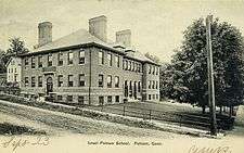
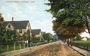 School Street about 1910
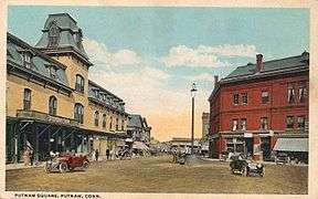 Putnam Square, about 1915
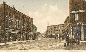 Main Street, looking south, about 1908
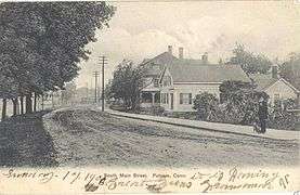 South Main Street about 1906
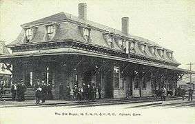 "Old" railroad depot, 1906
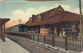 "New" train station, about 1906
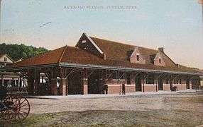 The station in 1914
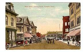 Main St. c. 1915
Schools
- Public
- Putnam Elementary School — K-5th grade
- Putnam Middle School — 6th-8th grade
- Putnam High School — 9th-12th grade
- Private
- Putnam Science Academy — Private school for students in Grades 9-12 wanting to further their education in the world of science.
- Tri-State Christian Academy (grades K-8)
National competitions
- Putnam Science Academy has entered and won the Connecticut Science Olympiad for four years in a row (2004–2005, 2005–2006, 2006–2007, and 2007–2008).[6][7]
- Hacibey Catalbasoglu and Ahmet Sirrik won 1st place for Putnam Science Academy in Entomology at the 2006 National Science Olympiad hosted at Indiana University.
Transportation
Putnam is served by the Northeastern Connecticut Transit District.
Notable locations
- Cady-Copp House - historic home at 115 Liberty Highway and added to the National Register of Historic Places in 2001.
- Putnam Town Hall - historic building on 126 Church Street and added to the National Register of Historic Places in 1993.
- Putnam Railroad Station - historic train station at 35 and 45-47 Main Street and added to the National Register of Historic Places in 2007.
Notable people
- Bruce Boisclair (1952-) - baseball outfielder
- Henry Breault (1900-1941) - Medal of Honor recipient
- Brooke Brodack (1986-) - actress and comedian
- Lewis C. Carpenter (1836-1908) - congressman from South Carolina
- John N. Dempsey (1915-1989) - Mayor of Putnam, Governor of Connecticut
- Candy LaChance (1870-1932) - baseball first baseman
- Richard Normand Langlois (1952-) - economist and professor
- William St. Onge (1914-1970) - Congressman
- Michael Bruce Ross (1959-2005) - serial killer
- Bob Schaefer (1944-) - baseball coach
- Rollie Sheldon (1936-) - baseball pitcher
- Gertrude Chandler Warner (1890-1979) - children's author
References
- ↑ The Connecticut Magazine: An Illustrated Monthly. Connecticut Magazine Company. 1903. p. 334.
- ↑ Oberländer, Erwin. The All-Russian Fascist Party, p. 163
- ↑ "Annual Estimates of the Resident Population for Incorporated Places: April 1, 2010 to July 1, 2014". Archived from the original on May 23, 2015. Retrieved June 4, 2015.
- ↑ "Census of Population and Housing". Census.gov. Retrieved June 4, 2015.
- ↑ "American FactFinder". United States Census Bureau. Retrieved 2008-01-31.
- ↑ 2007 Division C - State Results Archived 2007-09-27 at the Wayback Machine. - Connecticut Science Olympiad - (Microsoft Excel *.XLS document)
- ↑ 2008 Division C - State Results - Connecticut Science Olympiad - (Microsoft Excel *.XLS document)
External links
- Town of Putnam
- Putnam Public Library
- Aspinock Historical Society of Putnam
- Mystic Country: The Eastern Regional Tourism District
- Putnam Science Academy
- Bradley Playhouse
- Putnam CT Web Index

- "Putnam". New International Encyclopedia. 1905.
- "Putnam". Encyclopædia Britannica (11th ed.). 1911.
- "Putnam". Encyclopedia Americana. 1920.
- "Putnam". Collier's New Encyclopedia. 1921.

Municipalities and communities of Windham County, Connecticut, United States | ||
|---|---|---|
| Towns | 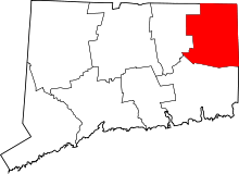 | |
| Borough | ||
| Former cities | ||
| Other communities | ||