East Hartford, Connecticut
| East Hartford, Connecticut | |||
|---|---|---|---|
| Town | |||
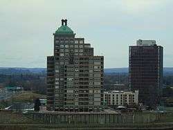 The skyline near the Connecticut River | |||
| |||
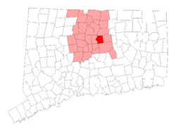 Location in Hartford County, Connecticut | |||
 East Hartford Location in the contiguous United States and Connecticut 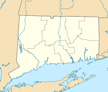 East Hartford East Hartford (Connecticut) | |||
| Coordinates: 41°45′41″N 72°36′55″W / 41.76139°N 72.61528°WCoordinates: 41°45′41″N 72°36′55″W / 41.76139°N 72.61528°W | |||
| Country |
| ||
| U.S. state |
| ||
| County | Hartford | ||
| NECTA | Hartford | ||
| Region | Capitol Region | ||
| Incorporated | 1783 | ||
| Government | |||
| • Type | Mayor-council | ||
| • Mayor | Marcia Leclerc (D) | ||
| Area | |||
| • Total | 18.7 sq mi (48.5 km2) | ||
| • Land | 18.0 sq mi (46.6 km2) | ||
| • Water | 0.7 sq mi (1.9 km2) | ||
| Elevation | 39 ft (12 m) | ||
| Population (2010)[1] | |||
| • Total | 51,252 | ||
| • Density | 2,740.7/sq mi (1,058.2/km2) | ||
| Time zone | UTC-5 (Eastern) | ||
| • Summer (DST) | UTC-4 (Eastern) | ||
| ZIP code | 06108, 06118 | ||
| Area code(s) | 860 | ||
| FIPS code | 09-22630 | ||
| GNIS feature ID | 0213424 | ||
| Website |
www | ||

East Hartford is a town in Hartford County, Connecticut, United States. The population was 51,252 at the 2010 census.[1]
Geography
The town is located on the east bank of the Connecticut River, directly across from Hartford, Connecticut. The town includes the neighborhoods of Burnside and Hockanum. According to the United States Census Bureau, the town has a total area of 18.7 square miles (48.5 km2), of which 18.0 square miles (46.6 km2) is land and 0.73 square miles (1.9 km2), or 3.93%, is water.[1]
History
When the Connecticut Valley became known to Europeans around 1631, it was inhabited by what were known as the River Tribes — a number of small clans of Native Americans living along the Great River and its tributaries. Of these tribes the Podunks occupied territory now lying in the towns of East Hartford and South Windsor, and numbered, by differing estimates, from sixty to two hundred bowmen. They were governed by two sachems, Waginacut and Arramamet, and were connected in some way with the Native Americans who lived across the Great River, in what is now Windsor. The region north of the Hockanum River was generally called Podunk; that south of the river, Hockanum; but these were no certain designations, and by some all the meadow along the Great River was called Hockanum.[2]
In 1659, Thomas Burnham (1617–1688) purchased the tract of land now covered by the towns of South Windsor and East Hartford from Tantinomo, chief sachem of the Podunk Indians.[2] Burnham lived on the land and later willed it to his nine children.[3] The town of Hartford once included the land now occupied by the towns of East Hartford, Manchester, Bolton, Vernon, and West Hartford. In 1783, East Hartford became a separate town, which included Manchester in its city limits until 1823.[2]
Demographics
As of [4] 2010, there were 51,252 people, 20,206 households, and 12,830 families residing in the town. The population density was 3,200 people per square mile (1,250/km2). There were 21,328 housing units at an average density of 1,180.2 per square mile (455.8/km²). The racial makeup of the town was 38.4% non-Hispanic White, 25.9% Black or African American, 0.03% Native American, 5.9% Asian, 0.04% Pacific Islander, 0.3% from other races, and 1.9% from two or more races. Hispanic or Latino of any race were 28.3% of the population.
There were 20,206 households out of which 29.2% had children under the age of 18 living with them, 41.5% were married couples living together, 17.4% had a female householder with no husband present, and 36.5% were non-families. 30.2% of all households were made up of individuals and 11.3% had someone living alone who was 65 years of age or older. The average household size was 2.42 and the average family size was 3.01.
In the town, the population was spread out with 24.1% under the age of 18, 7.8% from 18 to 24, 30.2% from 25 to 44, 22.3% from 45 to 64, and 15.6% who were 65 years of age or older. The median age was 37 years. For every 100 females, there were 91.4 males. For every 100 females age 18 and over, there were 87.8 males.
The median income for a household in the town was $41,424, and the median income for a family was $50,540. Males had a median income of $36,823 versus $29,860 for females. The per capita income for the town was $21,763. About 8.1% of families and 10.3% of the population were below the poverty line, including 15.5% of those under age 18 and 7.3% of those age 65 or over.
| Voter Registration and Party Enrollment as of October 30, 2007[5] | |||||
|---|---|---|---|---|---|
| Party | Active Voters | Inactive Voters | Total Voters | Percentage | |
| Democratic | 11,321 | 1,088 | 12,409 | 45.82% | |
| Republican | 2,820 | 305 | 3,125 | 11.54% | |
| Unaffiliated | 10,087 | 1,420 | 11,507 | 42.48% | |
| Minor Parties | 38 | 6 | 44 | 0.16% | |
| Total | 24,266 | 2,819 | 27,085 | 100% | |
| Historical population | |||
|---|---|---|---|
| Census | Pop. | %± | |
| 1820 | 3,375 | — | |
| 1850 | 2,497 | — | |
| 1860 | 2,951 | 18.2% | |
| 1870 | 3,007 | 1.9% | |
| 1880 | 3,500 | 16.4% | |
| 1890 | 4,455 | 27.3% | |
| 1900 | 6,406 | 43.8% | |
| 1910 | 8,138 | 27.0% | |
| 1920 | 11,648 | 43.1% | |
| 1930 | 17,125 | 47.0% | |
| 1940 | 18,615 | 8.7% | |
| 1950 | 29,933 | 60.8% | |
| 1960 | 43,977 | 46.9% | |
| 1970 | 57,583 | 30.9% | |
| 1980 | 52,563 | −8.7% | |
| 1990 | 50,452 | −4.0% | |
| 2000 | 49,575 | −1.7% | |
| 2010 | 51,252 | 3.4% | |
Economy
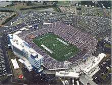
East Hartford is home to the headquarters of Pratt & Whitney,[6] part of the United Technologies conglomerate. The manufacturing plant takes up a significant amount of East Hartford's area, and at its peak, it employed tens of thousands of people; [7] however, currently, it only employs about 7,621.[8] East Hartford also contains a Coca-Cola bottling plant, located on Main Street. The city is dotted with industrial and suburban office parks, and in the early 2000s, urban planners strategically situated a regional stadium, Rentschler Stadium (construction completed September 2003), and a hunting and camping focused department store, Cabela's, on the then vacant former Pratt & Whitney company airfield, Rentschler Field.[9]
Top employers
According to East Hartford's Comprehensive Annual Financial Report,[10] the top employers in the city are:
| # | Employer | # of Employees |
|---|---|---|
| 1 | Pratt and Whitney | 9,000 |
| 2 | Town of East Hartford | 1,698 |
| 3 | Goodwin College | 720 |
| 4 | Coca-Cola Refreshments | 600 |
| 5 | Bank of America | 550 |
| 6 | United Technologies Corporation Research Center | 515 |
| 7 | Riverside Health and Rehabilitation Center | 438 |
| 8 | Connecticut Bureau of Enterprise Systems and Technology | 397 |
| 9 | Cabela's | 326 |
| 10 | DXC Technology | 297 |
| 11 | Connecticut Natural Gas | 263 |
| 12 | Red Thread, a subsidiary of Steelcase | 175 |
| 13 | Connecticut Judicial Branch | 130 |
| 14 | United Steel | 127 |
| 15 | Clearwater Paper | 98 |
Education
Attractions
The Great River Park is located on the banks of the Connecticut River in East Hartford, providing riverside activities for the town.[11]
Wickham Park, located in East Hartford and Manchester, features Oriental gardens, fountains, open fields, woodlands, ponds, picnic areas, softball fields, and an aviary. The west side of the park offers a scenic view of East Hartford and the skyline of Hartford across the Connecticut River and is a popular site for weddings. It also has a very popular sledding hill in the winter.[12]
Nearby, Rentschler Field Stadium is home of the University of Connecticut Huskies football team.[13]
Notable people
- Milton Avery, artist
- Lawrence Brainerd, businessman, abolitionist and United States senator from Vermont
- Mary Cadorette, actress
- Samuel Colt, founder of Colt Firearms
- Francis Patrick Garvan, lawyer and longtime president of the Chemical Foundation
- John A. Gurley, U.S. Representative from Ohio during the early part of the American Civil War
- John Larson, current U.S. Representative from Connecticut's 1st congressional district
- Hiram N. Moulton, mayor of Madison, Wisconsin
- Aaron Olmstead, sea captain, namesake of several cities in Ohio
- Denison Olmsted, physicist and astronomer
- Frederick Law Olmsted, renowned urban and suburban planner famous for many of the New York City parks and Stanford University's campus lived and studied for much of his youth between his primary residence in Hartford and his father's childhood home in East Hartford.
- Gérard Ouellet, member of the Canadian House of Commons
- Diane Venora, actress
References
- 1 2 3 "Geographic Identifiers: 2010 Demographic Profile Data (G001): East Hartford town, Hartford County, Connecticut". U.S. Census Bureau, American Factfinder. Retrieved November 26, 2012.
- 1 2 3 Goodwin, Joseph Olcott (1879). East Hartford: Its History and Traditions. Hartford, Connecticut: Case, Lockwood, and Brainard Co.
- ↑ Burnham, Roderick Henry (1869). The Burnham Family; Or Genealogical Records of the Descendants of the Four. Hartford, Connecticut: Case, Lockwood, and Brainard Co.
- ↑ "Archived copy". Archived from the original on August 31, 2015. Retrieved September 1, 2015.
- ↑ "Registration and Party Enrollment Statistics as of October 30, 2007" (PDF). Connecticut Secretary of State. Retrieved 2008-09-18.
- ↑ "Contact Us." Pratt & Whitney. Retrieved on January 7, 2011. "Corporate Headquarters Pratt & Whitney 400 Main Street East Hartford, CT 06108."
- ↑ Chen, Xiangming and John Shemo. 2013. “Shifting Fortunes: Hartford’s Global and Regional Economic Dimensions.” Pp. 193-218 in Confronting Urban Legacy: Rediscovering Hartford and New England's Forgotten Cities. Xiangming Chen and Nick Bacon (eds). Lanham, MD: Lexington Books.
- ↑ Town of East Hartford CAFR Archived 2013-07-24 at the Wayback Machine.
- ↑ Bacon, Nick. 2013. “Podunk after Pratt: Place and Placelessness in East Hartford, CT.” Pp. 46-64 in Confronting Urban Legacy: Rediscovering Hartford and New England's Forgotten Cities. Xiangming Chen and Nick Bacon (eds). Lanham, MD: Lexington Books.
- ↑ Town of East Hartford Annual Reports
- ↑ "Great River Park | Riverfront Recapture". www.riverfront.org. Retrieved 2017-05-22.
- ↑ "Wickham Park, Manchester Connecticut". www.wickhampark.org. Retrieved 2017-05-22.
- ↑ "UCONNHUSKIES.COM :: University of Connecticut Huskies Official Athletic Site". www.uconnhuskies.com. Retrieved 2017-05-22.
External links
Municipalities and communities of Hartford County, Connecticut, United States | ||
|---|---|---|
| Cities | 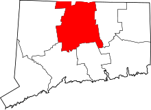 | |
| Towns | ||
| CDPs | ||
| Other communities | ||