Litchfield, Connecticut
| Litchfield, Connecticut | ||
|---|---|---|
| Town | ||
| ||
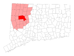 Location in Litchfield County, Connecticut | ||
| Coordinates: 41°44′50″N 73°11′23″W / 41.74722°N 73.18972°WCoordinates: 41°44′50″N 73°11′23″W / 41.74722°N 73.18972°W | ||
| Country |
| |
| U.S. state |
| |
| County | Litchfield | |
| Region | Northwest Hills | |
| Incorporated | 1719[1] | |
| Government | ||
| • Type | Selectman-town meeting | |
| • First selectman | Leo Paul, Jr. (R) | |
| • Selectmen |
Paul J. Parsons (R) Jonathan E. Torrant (R) Diane Knox (D) Jeffrey J. Zullo (D) | |
| Area | ||
| • Total | 56.8 sq mi (147.1 km2) | |
| • Land | 56.1 sq mi (145.2 km2) | |
| • Water | 0.7 sq mi (1.9 km2) | |
| Elevation | 495 ft (151 m) | |
| Population (2010)[2] | ||
| • Total | 8,466 | |
| • Estimate (2016)[3] | 8,175 | |
| • Density | 200/sq mi (60/km2) | |
| Time zone | UTC-5 (EST) | |
| • Summer (DST) | UTC-4 (EDT) | |
| ZIP code | 06750, 06759 | |
| Area code(s) | 860 | |
| FIPS code | 09-43370 | |
| GNIS feature ID | 0213452 | |
| Website |
www | |

Litchfield is a town in and former county seat of Litchfield County, Connecticut, United States.[4] The population was 8,466 at the 2010 census. The boroughs of Bantam and Litchfield are located within the town. There are also three unincorporated villages: East Litchfield, Milton, and Northfield.
History
Litchfield incorporated in 1719. The town derives its name from Lichfield, in England.[5]
Geography
Located southwest of Torrington, Litchfield also includes part of Bantam Lake. According to the United States Census Bureau, the town has a total area of 56.8 square miles (147.1 km²), of which, 56.1 square miles (145.2 km²) of it is land and 0.7 square miles (1.9 km²) of it (1.3%) is water.
Litchfield is about 95 mi (153 km) from Central Park in New York, about 50 mi (80 km) from the Hudson River valley, and about 40 mi (64 km) from the nearest sea coast, on Long Island Sound.
Principal communities
- Bantam (borough)
- East Litchfield (unincorporated village)
- Litchfield (borough / town center)
- Milton (unincorporated village)
- Northfield (unincorporated village)
Demographics
| Historical population | |||
|---|---|---|---|
| Census | Pop. | %± | |
| 1790 | 20,342 | — | |
| 1800 | 4,285 | −78.9% | |
| 1810 | 4,639 | 8.3% | |
| 1820 | 4,610 | −0.6% | |
| 1830 | 4,456 | −3.3% | |
| 1840 | 4,038 | −9.4% | |
| 1850 | 3,953 | −2.1% | |
| 1860 | 3,200 | −19.0% | |
| 1870 | 3,113 | −2.7% | |
| 1880 | 3,410 | 9.5% | |
| 1890 | 3,304 | −3.1% | |
| 1900 | 3,214 | −2.7% | |
| 1910 | 3,005 | −6.5% | |
| 1920 | 3,180 | 5.8% | |
| 1930 | 3,574 | 12.4% | |
| 1940 | 4,029 | 12.7% | |
| 1950 | 4,964 | 23.2% | |
| 1960 | 6,264 | 26.2% | |
| 1970 | 7,399 | 18.1% | |
| 1980 | 7,605 | 2.8% | |
| 1990 | 8,365 | 10.0% | |
| 2000 | 8,316 | −0.6% | |
| 2010 | 8,466 | 1.8% | |
| Est. 2016 | 8,175 | [3] | −3.4% |
| U.S. Decennial Census[6] | |||
As of the census[7] of 2000, there were 8,316 people, 3,310 households, and 2,303 families residing in the town. The population density was 148.4 people per square mile (57.3/km²). There were 3,629 housing units at an average density of 64.7 per square mile (25.0/km²). The racial makeup of the town was 96.99% White, 0.75% Black or African American, 0.23% Native American, 0.47% Asian, 0.01% Pacific Islander, 0.46% from other races, and 1.09% from two or more races. Hispanic or Latino of any race were 1.56% of the population.
There were 3,310 households out of which 31.2% had children under the age of 18 living with them, 59.9% were married couples living together, 7.2% had a female householder with no husband present, and 30.4% were non-families. 26.5% of all households were made up of individuals and 13.2% had someone living alone who was 65 years of age or older. The average household size was 2.45 and the average family size was 2.98.
In the town, the population was spread out with 25.2% under the age of 18, 3.6% from 18 to 24, 25.6% from 25 to 44, 28.6% from 45 to 64, and 17.0% who were 65 years of age or older. The median age was 43 years. For every 100 females, there were 92.5 males. For every 100 females age 18 and over, there were 90.3 males.
The median income for a household in the town was $58,418, and the median income for a family was $70,594. Males had a median income of $50,284 versus $31,787 for females. The per capita income for the town was $30,096. About 2.8% of families and 4.0% of the population were below the poverty line, including 2.6% of those under age 18 and 5.2% of those age 65 or over.
| Voter registration and party enrollment as of October 25, 2005[8] | |||||
|---|---|---|---|---|---|
| Party | Active voters | Inactive voters | Total voters | Percentage | |
| Republican | 2,044 | 90 | 2,134 | 33.59% | |
| Democratic | 1,384 | 67 | 1,451 | 22.84% | |
| Unaffiliated | 2,596 | 165 | 2,761 | 43.45% | |
| Minor Parties | 8 | 0 | 8 | 0.13% | |
| Total | 6,032 | 322 | 6,354 | 100% | |
Government and infrastructure

The town houses the 1812 Litchfield County Jail, the town's oldest public building and a former jail.[9] The facility, controlled by the Connecticut state government, historically held inmates convicted of minor offenses.[10] Governor of Connecticut Lowell P. Weicker Jr. ordered the facility closed for financial reasons in 1993. It was converted into the McAuliffe Manor, a substance abuse treatment center for women operated by Naugatuck Valley HELP Inc.,[10] but in 2009 the contract between Naugatuck Valley HELP Inc. and the state expired, leading to the closure of McAuliffe Manor.[11]
Transportation
Route 202 is the main east-west road connecting Bantam and Litchfield center to the city of Torrington. Route 63 runs north-south through the town center. The Route 8 expressway runs along the town line with Harwinton. It can be accessed from the town center via Route 118. The town is also served by buses from the Northwestern Connecticut Transit District connecting to the city of Torrington. The Shepaug Valley Railroad opened a Litchfield terminal in 1872, but passenger service ended in 1930 and freight service in 1948.[12]
Education
Litchfield Public Schools operates public schools. Litchfield High School is the area high school.
Notable people
- Andrew Adams[13]
- Josephine Cables Aldrich (1843-1917), spiritualist, Theosophist, editor, and publisher
- Ethan Allen
- Catharine Beecher
- Isabella Beecher Hooker – women's suffrage activist[14]
- Harriet Beecher Stowe
- Henry Ward Beecher
- Lyman Beecher
- Mary Charlotte Ward Granniss Webster Billings
- Solyman Brown
- Adelaide Deming
- Dick Ebersol
- Jerome Fuller
- Elizabeth Gilbert – author of Eat, Pray, Love
- F. Norton Goddard
- Benjamin Hanks (1755–1824) – goldsmith, instrument maker, and first maker of bronze cannons and church bells in America[15]
- Uriel Holmes[16]
- Daniel Albion "Jumping Jack" Jones (1860–1936) – professional baseball pitcher
- Madeleine L'Engle[17]
- Admiral Charles B. McVay III
- Phineas Miner[18]
- Joseph Robert Morris - entrepreneur, investor, mayor of Houston, Texas, was born and raised in Milton[19]
- Samuel S. Phelps[20]
- John Pierpoint, Chief Justice of the Vermont Supreme Court[21]
- Robert Pierpoint, Lieutenant Governor of Vermont[22]
- Austin M. Purves, Jr.[23]
- Tapping Reeve
- Mary Livingston Ripley – horticulturist, entomologist, and photographer[24]
- Susan Saint James – actress[25]
- Richard Skinner, Governor of Vermont[26]
- Roger Skinner, Judge of the United States District Court for the Northern District of New York[27]
- Benjamin Tallmadge[28]
- Frank Livingston Underwood (1844–1918), banker, copper magnate, railroad founder
- Emily Noyes Vanderpoel (1842–1939), painter, writer, philanthropist
- Louis Fenn Wadsworth (1825–1908) – early baseball pioneer
- Paul Winter – saxophonist
- Oliver Wolcott, Sr.
- Oliver Wolcott, Jr.[29]
On the National Register of Historic Places
- Capt. William Bull Tavern — CT 202 (added July 30, 1983)
- Henry B. Bissell House — 202 Maple St. (added October 7, 1990)
- J. Howard Catlin House — 14 Knife Shop Rd. (added September 6, 1993) (Since demolished)
- Litchfield Historic District — Roughly both sides of North and South Sts. between Gallows Lane and Prospect St. (added December 24, 1968)
- Milton Historic District (added March 14, 1978)
- Northfield Knife Company Site (added May 8, 1997)
- Oliver Wolcott House — South St. (added December 11, 1971)
- Rye House — 122–132 Old Mount Tom Rd. (added September 10, 2000)
- Tapping Reeve House and Law School — South St. (added November 15, 1966)
- Topsmead — 25 and 46 Chase Rd. (added December 19, 1993)
See also
References
- ↑ "Litchfield Connecticut". City-Data.com. Retrieved November 4, 2012.
- ↑ U.S. Census Bureau Population Estimates
- 1 2 "Population and Housing Unit Estimates". Retrieved June 9, 2017.
- ↑ "Find a County". National Association of Counties. Retrieved 2011-06-07.
- ↑ The Connecticut Magazine: An Illustrated Monthly. Connecticut Magazine Company. 1903. p. 332.
- ↑ "Census of Population and Housing". Census.gov. Retrieved June 4, 2015.
- ↑ "American FactFinder". United States Census Bureau. Retrieved 2008-01-31.
- ↑ "Registration and Party Enrollment Statistics as of October 25, 2005" (PDF). Connecticut Secretary of State. Archived from the original (PDF) on September 23, 2006. Retrieved October 2, 2006.
- ↑ Cooper, Anneliese (2014-06-06). "'Orange Is the New Black's Prison Location Isn't Real, But It's Not Entirely Fictional Either". Bustle. Retrieved 2017-08-04.
- 1 2 Ryan, Bill (1994-10-16). "Litchfield's Jail Begins Another Era With Women Hoping for New Lives". The New York Times. Retrieved 2017-08-05.
- ↑ Taylor, Alex (2009-05-22). "Rehab center closing: McCauliffe Manor's contract expires". The Register Citizen. Retrieved 2017-08-05.
- ↑ Alfred S. Dillistin (June 1949). "Shepaug Epic". The Lure of the Litchfield Hills. Retrieved April 30, 2014.
- ↑ "ADAMS, Andrew, (1736–1797)". Biographical Directory of the United States Congress. Retrieved November 4, 2012.
- ↑ "Isabella Beecher Hooker". Connecticut Women's Hall of Fame. Retrieved May 23, 2014.
- ↑ Skinner, Charles. "Bell Casting in Troy". Meneeley Bell Online Museum. Archived from the original on June 30, 2014. Retrieved July 12, 2013.
- ↑ "HOLMES, Uriel, (1764–1827)". Biographical Directory of the United States Congress. Retrieved November 4, 2012.
- ↑ "Madeleine L'Engle". IMDb. Retrieved November 4, 2012.
- ↑ "MINER, Phineas, (1777–1839)". Biographical Directory of the United States Congress. Retrieved November 4, 2012.
- ↑ History of Texas, together with a biographical history of the cities of Houston and Galveston. Chicago: Lewis Publishing Company. 1895. pp. 393–396.
- ↑ "PHELPS, Samuel Shethar, (1793–1855)". Biographical Directory of the United States Congress. Retrieved November 4, 2012.
- ↑ Ullery, Jacob G. (1894). Men of Vermont Illustrated. Brattleboro, VT: Transcript Publishing Company. pp. 183–184.
- ↑ Men of Vermont Illustrated.
- ↑ Austin M. Purves, Jr.
- ↑ "Mary L. Ripley, Smithsonian Leader". The Washington Times. Retrieved 10 November 2012.
- ↑ "Susan Saint James". Connecticut Women's Hall of Fame. Retrieved May 23, 2014.
- ↑ "Biography, Richard Skinner". The Ledger: A Database of Students of the Litchfield Law School and the Litchfield Female Academy. Litchfield, CT: Litchfield Historical Society. 2010. Retrieved July 8, 2017.
- ↑
- Johnson, Crisfield (1878). History of Washington Co., New York. Everts & Ensign: Philadelphia, PA.
- Kilbourne, Payne Kenyon (1859). Sketches and Chronicles of the Town of Litchfield, Connecticut. Hartford, CT: Case, Lockwood and Company. p. 211.
- ↑ "TALLMADGE, Benjamin, (1754–1835)". Biographical Directory of the United States Congress. Retrieved November 4, 2012.
- ↑ "Connecticut Governor Oliver Wolcott Jr.publisher=National Governors Association". Retrieved November 4, 2012.
Further reading
- Carley, Rachel. Litchfield: The Making of a New England Town (Litchfield: Litchfield Historical Society, 2011). 303 pp.
External links
| Wikimedia Commons has media related to Litchfield, Connecticut. |
- Litchfield town's web page
- General information about Litchfield
- Litchfield Historical Society
- Northwest Connecticut Convention and Visitors Bureau
- Northwest Connecticut Arts Council
- Northwestern Connecticut Community College in Winsted
- Litchfield Weather
- City-Data.com
- epodunk: Profile for Litchfield, Connecticut
Municipalities and communities of Litchfield County, Connecticut, United States | ||
|---|---|---|
| Consolidated city |  | |
| Towns | ||
| Boroughs | ||
| CDPs |
| |
| Other communities | ||
| Indian reservation | ||

| Topics | |||||||
|---|---|---|---|---|---|---|---|
| States | |||||||
| Major cities | |||||||
| State capitals | |||||||
| Transportation |
| ||||||
| |||||||