Roxbury, Connecticut
| Roxbury, Connecticut | ||
|---|---|---|
| Town | ||
| ||
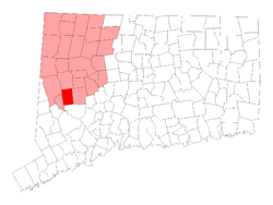 Location in Litchfield County, Connecticut | ||
| Coordinates: 41°33′07″N 73°18′09″W / 41.55194°N 73.30250°WCoordinates: 41°33′07″N 73°18′09″W / 41.55194°N 73.30250°W | ||
| Country |
| |
| U.S. state |
| |
| County | Litchfield | |
| Region | Northwest Hills | |
| Incorporated | 1796 | |
| Government | ||
| • Type | Selectman-town meeting | |
| • First selectman | Barbara M. Henry (R) | |
| • Selectman | Russell Dirienzo (R) | |
| • Selectman | Jim Conway (D) | |
| Area | ||
| • Total | 26.3 sq mi (68.1 km2) | |
| • Land | 26.2 sq mi (67.9 km2) | |
| • Water | 0.1 sq mi (0.2 km2) | |
| Elevation | 541 ft (165 m) | |
| Population (2005) | ||
| • Total | 2,327 | |
| • Density | 89/sq mi (34/km2) | |
| Time zone | UTC−5 (Eastern) | |
| • Summer (DST) | UTC−4 (Eastern) | |
| ZIP code | 06783 | |
| Area code(s) | 203/475, 860/959 | |
| FIPS code | 09-65930 | |
| GNIS feature ID | 0213498 | |
| Website |
www | |
Roxbury is a town in Litchfield County, Connecticut, United States. The population was 2,136 at the 2000 census.
History

Roxbury, whose Indian name was "Shepaug", a Mahican name signifiying "rocky water", was settled about the year 1713. Originally a part of Woodbury, the town was incorporated in October 1796. Roxbury is either descriptively named, or the name is a transfer from Roxbury, Massachusetts.[1]
Mine Hill and its minerals have been associated with Roxbury since the middle of the 18th century. A silver mine was opened here and was later found to contain spathic iron, specially adapted to steel making and a small smelting furnace was built. The abundance of granite found in many of Mine Hill's quarries provided the building material for the ore roaster and blast furnace, as well as for such world wonders as the Brooklyn Bridge and Grand Central Terminal in New York City.
Geography
According to the United States Census Bureau, the town has a total area of 26.3 square miles (68 km2), of which, 26.2 square miles (68 km2) of it is land and 0.1 square miles (0.26 km2) of it (0.23%) is water.
Principal communities
- Judd's Bridge
- Roxbury center
- Roxbury Falls
- Roxbury Station
On the National Register of Historic Places
Three places in Roxbury, Connecticut are included on the National Register of Historic Places listing.[2] They are:
- Roxbury Center (CT 67, Weller's Bridge Rd., South and Church Streets); 32 buildings in designated local historic district.
- Roxbury Iron Mine and Furnace Complex
- Roxbury Station Historic District (added 2009) (CT 67, Botsford Hill, Hodge, and Mine Hill Roads)
Demographics
| Historical population | ||
|---|---|---|
| Year | Pop. | ±% |
| 1830 | 1,122 | — |
| 1840 | 971 | −13.5% |
| 1850 | 1,114 | +14.7% |
| 1860 | 992 | −11.0% |
| 1870 | 919 | −7.4% |
| 1880 | 950 | +3.4% |
| 1890 | 936 | −1.5% |
| 1900 | 1,087 | +16.1% |
| 1910 | 837 | −23.0% |
| 1920 | 647 | −22.7% |
| 1930 | 553 | −14.5% |
| 1940 | 660 | +19.3% |
| 1950 | 740 | +12.1% |
| 1960 | 912 | +23.2% |
| 1970 | 1,238 | +35.7% |
| 1980 | 1,468 | +18.6% |
| 1990 | 1,825 | +24.3% |
| 2000 | 2,136 | +17.0% |
| Source: [3][4][5] | ||
As of the census[6] of 2000, there were 2,136 people, 848 households, and 620 families residing in the town. The population density was 81.4 people per square mile (31.4/km²). There were 1,018 housing units at an average density of 38.8 per square mile (15.0/km²). The racial makeup of the town was 97.24% White, 0.23% African American, 0.19% Native American, 0.94% Asian, 0.66% from other races, and 0.75% from two or more races. Hispanic or Latino of any race were 1.31% of the population.
There were 848 households out of which 29.2% had children under the age of 18 living with them, 66.5% were married couples living together, 4.2% had a female householder with no husband present, and 26.8% were non-families. 20.3% of all households were made up of individuals and 7.1% had someone living alone who was 65 years of age or older. The average household size was 2.52 and the average family size was 2.95.
In the town, the population was spread out with 22.8% under the age of 18, 3.7% from 18 to 24, 25.5% from 25 to 44, 34.3% from 45 to 64, and 13.8% who were 65 years of age or older. The median age was 44 years. For every 100 females, there were 104.0 males. For every 100 females age 18 and over, there were 102.0 males.
The median income for a household in the town was $87,794, and the median income for a family was $97,672. Males had a median income of $61,477 versus $45,417 for females. The per capita income for the town was $56,769. About 3.0% of families and 3.9% of the population were below the poverty line, including 4.1% of those under age 18 and 6.3% of those age 65 or over.
Transportation
Route 67 is the main thoroughfare in the town, connecting it to New Milford and Southbury. The town is also served by secondary highways, Route 199 (to Washington) and Route 317 (to Woodbury).
Roads in Roxbury on the List of Connecticut State Scenic Highways
The following roads are Connecticut State Scenic Highways:[7]
- Connecticut Route 317; 0.40 from Painter Hill Road, west to Route 67. (added November 14, 1990)
- Connecticut Route 67; 0.87 mile from Ranny Hill Road, south to 0.30 mile south of Route 317. (added November 14, 1990)
- Connecticut Route 67; 2.90 miles from the Roxbury/Bridgewater Town line, east to Ranny Hill Road. (added August 23, 1996)
Local media
- Waterbury Republican-American - A Waterbury-based independent daily newspaper.
- The Danbury News-Times - A Danbury-based daily newspaper.
- The Greater New Milford Spectrum - A MediaNews Group-owned weekly paper.
- Voices - A local newspaper serving Southbury, Middlebury, Oxford, Seymour, Naugatuck, Woodbury, Bethelhem, New Preston, Washington, Washington Depot, Roxbury, Bridgewater, Monroe, Sandy Hook and Newtown.
Education
Regional School District 12 operates the Booth Free School in Roxbury,[8] as well as the Shepaug Valley School (secondary) in Washington.
Notable people
- Graydon Carter (1949–) Editor, Vanity Fair.
- Lindsey Jacobellis (1985–Present) Olympic Athlete.
- Mercer Mayer (1943-) Children's book author (Little Critter)
- Frank McCourt (1930-2009) Author, Angela's Ashes.
- Arthur Miller (1915–2005) American playwright.
- Rebecca Miller (1962-) Actress and Filmmaker.
- Marilyn Monroe (1926–1962) Actress.
- Inge Morath (1923–2002) Austrian Photographer.
- Rex Reed (1938–) Film Critic.
- William Styron (1925–2006) Author, Sophie's Choice.[9]
- Joe Wanag (1966–Present) Olympic Athlete.
- Seth Warner (1743–1784) Green Mountain Boys.
- Richard Widmark (1914–2008) Actor.
References
- ↑ The Connecticut Magazine: An Illustrated Monthly. Connecticut Magazine Company. 1903. p. 334.
- ↑ National Register of Historic Places listings in Litchfield County, Connecticut
- ↑ Archived February 28, 2008, at the Wayback Machine.
- ↑ Archived February 28, 2008, at the Wayback Machine.
- ↑ Archived February 28, 2008, at the Wayback Machine.
- ↑ "American FactFinder". United States Census Bureau. Retrieved 2008-01-31.
- ↑ Criteria For Designation Of
- ↑ "STRATEGIC SCHOOL PROFILE 2012-13 Elementary School K-6 Edition Booth Free School." Regional School District 12. Retrieved on January 20, 2017.
- ↑ Life with Father | Vanity Fair
External links
- Roxbury official website
- Shepaug Regional School District # 12 official website
- Northwest Connecticut Convention and Visitors Bureau
Municipalities and communities of Litchfield County, Connecticut, United States | ||
|---|---|---|
| Consolidated city | 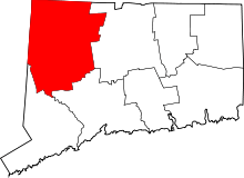 | |
| Towns | ||
| Boroughs | ||
| CDPs |
| |
| Other communities | ||
| Indian reservation | ||

| Topics | |||||||
|---|---|---|---|---|---|---|---|
| States | |||||||
| Major cities | |||||||
| State capitals | |||||||
| Transportation |
| ||||||
| |||||||