Woodbury, Connecticut
| Woodbury, Connecticut | ||
|---|---|---|
| Town | ||
| ||
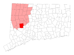 Location in Litchfield County, Connecticut | ||
| Coordinates: 41°33′43″N 73°12′34″W / 41.56194°N 73.20944°WCoordinates: 41°33′43″N 73°12′34″W / 41.56194°N 73.20944°W | ||
| Country | United States | |
| State | Connecticut | |
| NECTA | None | |
| Region | Central Naugatuck Valley | |
| Named | 1673 | |
| Government | ||
| • Type | Selectman-town meeting | |
| • First selectman | William Butterly (I) | |
| • Selectman | Martin Overton (D) | |
| • Selectman | Barbara Perkinson (R) | |
| Area | ||
| • Total | 36.7 sq mi (95.1 km2) | |
| • Land | 36.5 sq mi (94.4 km2) | |
| • Water | 0.3 sq mi (0.7 km2) | |
| Elevation | 243 ft (74 m) | |
| Population (2010)[1] | ||
| • Total | 9,975 | |
| • Density | 267/sq mi (103/km2) | |
| Time zone | UTC-5 (Eastern) | |
| • Summer (DST) | UTC-4 (Eastern) | |
| ZIP code | 06798 | |
| Area code(s) | 203/475 | |
| FIPS code | 09-87910 | |
| GNIS feature ID | 0213540 | |
| Website | http://www.woodburyct.org/ | |
Woodbury is a town in Litchfield County, Connecticut, United States. The population was 9,975 at the 2010 census.[1] The town center is also designated by the U.S. Census Bureau as a census-designated place (CDP). Woodbury was founded in 1673.
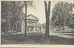
The center of Woodbury is distinctive because, unlike many New England towns, it is not nucleated. In Woodbury, the older buildings are arrayed in linear fashion along both sides of a road that stretches for over a mile. The public buildings in the National Register Historic District include the First Congregational Church (1818), the Old Town Hall (1846), the United Methodist Church, the St. Paul's Episcopal Church (1785), and the North Congregational Church (1816).
The most notable of the public buildings is the Masonic Temple (1839). It is a modest, clapboard, Greek Revival temple, notable less for its architecture than for its dramatic location, situated atop a high cliff accessed by a long flight of steps (there is a modern road at the rear). It is visible from a distance and is especially dramatic at night, when it is illuminated by spotlights. The Woodbury Temple echoes the many temples of the Greek world that were perched at the edge of high places from which they could be seen from miles around and from far out at sea.
Originally, the many historic houses on the street were residential. In the late twentieth century they were occupied by a series of antique shops.
Woodbury is one of the two towns in Litchfield County, along with Bethlehem, served by the area code 203/area code 475 overlay.
Geography
According to the United States Census Bureau, the town has a total area of 36.7 square miles (95 km2), of which 36.5 square miles (95 km2) is land and 0.3 square miles (0.78 km2) of (0.74%) is water. The CDP has a total area of 1.9 square miles (4.9 km2), all land.
Woodbury lies in the Pomperaug River Valley, a tributary of the Housatonic River. The Pomperaug River is formed in Woodbury by the confluence of the Nonnewaug River and the Weekeepeemee River.
Principal communities
- Hotchkissville
- Minortown
- Neufa
- North Woodbury
- Pomperaug
- Woodbury Center
- Woodlake
Climate
Woodbury has a humid continental climate (Köppen climate classification Dfb)
| Climate data for Woodbury, Connecticut | |||||||||||||
|---|---|---|---|---|---|---|---|---|---|---|---|---|---|
| Month | Jan | Feb | Mar | Apr | May | Jun | Jul | Aug | Sep | Oct | Nov | Dec | Year |
| Record high °F (°C) | 63 (17) |
67 (19) |
81 (27) |
93 (34) |
96 (36) |
96 (36) |
100 (38) |
98 (37) |
94 (34) |
88 (31) |
78 (26) |
68 (20) |
100 (38) |
| Average high °F (°C) | 34 (1) |
37 (3) |
46 (8) |
58 (14) |
70 (21) |
78 (26) |
83 (28) |
81 (27) |
73 (23) |
62 (17) |
50 (10) |
38 (3) |
59 (15) |
| Average low °F (°C) | 13 (−11) |
14 (−10) |
23 (−5) |
33 (1) |
43 (6) |
53 (12) |
58 (14) |
56 (13) |
48 (9) |
36 (2) |
28 (−2) |
19 (−7) |
35 (2) |
| Record low °F (°C) | −22 (−30) |
−18 (−28) |
−11 (−24) |
0 (−18) |
22 (−6) |
32 (0) |
38 (3) |
35 (2) |
23 (−5) |
14 (−10) |
5 (−15) |
−14 (−26) |
−22 (−30) |
| Average precipitation inches (mm) | 4.03 (102.4) |
3.3 (84) |
4.57 (116.1) |
4.29 (109) |
4.5 (114) |
4.2 (107) |
4.2 (107) |
4.44 (112.8) |
4.63 (117.6) |
4.44 (112.8) |
4.39 (111.5) |
4.17 (105.9) |
51.16 (1,300.1) |
| Source: The Weather Channel[2] | |||||||||||||
-The overall annual temperature is 47.25°F (8.47°C)
History
The founders of ancient Woodbury came from Stratford in the early 1670s. Ancient Woodbury consisted of the present towns of Woodbury, Southbury, Roxbury, Bethlehem, most of Washington and parts of Middlebury and Oxford.
Two groups of settlers came from Stratford. One, a group of religious dissidents unhappy with the church in Stratford, was led by Woodbury’s first minister, Reverend Zachariah Walker. The second group, led by Deacon Samuel Sherman, had been given approval by the general court to purchase land from local Native Americans in order to establish a new settlement. The two groups, consisting of fifteen families (about fifty people), arrived in ancient Woodbury, known as “Pomperaug Plantation", early in 1673.
In 1673 these original settlers drew up an agreement called the “Fundamental Articles,” which proclaimed that as many settlers as could be accommodated would be welcomed to the new settlement. The Fundamental Articles stated that expenses of establishing the settlement would be shared by its inhabitants, and that no one was to be given more than twenty-five or less than ten acres of land. Other sections of the articles provided for common land, and for land saved to be divided up for future inhabitants of the settlement.[3]
Signers of the Fundamental Articles:
- Samuel Sherman, Sr.
- Joshua Curtiss
- Lt. Joseph Judson, Sr.
- Titus Hinman
- Israel Curtiss
- David Jenkins
- John Wheeler
- John Judson
- Roger Terill
- Moses Johnson
- John Wyatt
- Samuel Munn
- John Sherman
- Samuel Stiles
- John Minor
- Eleazur Knowles
- Thomas Fairchild
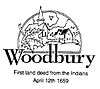
The settlement was named Woodbury, which means “dwelling place in the woods,” and was first recognized as a town in 1674. Deacon and captain John Minor was the first leader of the community during Woodbury’s early years. Minor was the first town clerk and along with Lieutenant Joseph Judson served as the first deputy to the Connecticut General Court from the town of Woodbury. On October 9, 1751, the town of Woodbury was transferred from Fairfield County at the formation of Litchfield County.
On March 25, 1783, a meeting of ten Episcopal clergy in Woodbury, Connecticut, elected Samuel Seabury the first American Episcopal bishop, the second presiding bishop of the Episcopal Church, USA, and the first bishop of Connecticut.
The Woodbury Songbook
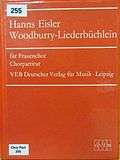
The German composer Hanns Eisler, who had taken asylum in the USA, fleeing from the Nazi rule in Germany, spent three and a half months (from June 15 to September 30, 1941) in Woodbury as guest of another German refugee, Dr. Joachim Schumacher, and his wife Sylvia. Joachim Schumacher taught classes in art history, musicology, philosophy, and other subjects at the Westover School in Middlebury. Sylvia Schumacher taught piano at Westover School and privately in her home.[4] Joachim Schumacher enticed Eisler to compose 20 songs on 16 US child verses or nursery rhymes and four texts in German language by Goethe, Eduard Mörike and Ignazio Silone. The songs were composed for female voices and suitable for a school chorus.[5] This was published as "The Woodbury Songbook", or, in German, "Das Woodbury Liederbüchlein" with the lyrics in English and German, unfortunately with a wrong spelling of Woodbury (with two "r"s). The German translations are by Wieland Herzfelde.[6]
Demographics
| Historical population | |||
|---|---|---|---|
| Census | Pop. | %± | |
| 1820 | 1,885 | — | |
| 1850 | 2,150 | — | |
| 1860 | 2,037 | −5.3% | |
| 1870 | 1,931 | −5.2% | |
| 1880 | 2,149 | 11.3% | |
| 1890 | 1,815 | −15.5% | |
| 1900 | 1,988 | 9.5% | |
| 1910 | 1,860 | −6.4% | |
| 1920 | 1,698 | −8.7% | |
| 1930 | 1,744 | 2.7% | |
| 1940 | 1,998 | 14.6% | |
| 1950 | 2,564 | 28.3% | |
| 1960 | 3,910 | 52.5% | |
| 1970 | 5,869 | 50.1% | |
| 1980 | 6,942 | 18.3% | |
| 1990 | 8,131 | 17.1% | |
| 2000 | 9,198 | 13.1% | |
| 2010 | 9,975 | 8.4% | |
| Est. 2014 | 9,719 | [7] | −2.6% |
| U.S. Decennial Census[8] | |||
As of the census[9] of 2010, there were 9,984 people, 4,219 households, and 2,772 families residing in the town. The population density was 252.2 people per square mile (97.4/km²). There were 3,869 housing units at an average density of 106.1 per square mile (41.0/km²). The racial makeup of the town was 97.25% White, 0.53% African American, 0.22% Native American, 1.15% Asian, 0.07% Pacific Islander, 0.22% from other races, and 0.57% from two or more races. Hispanic or Latino of any race were 1.65% of the population.
There were 3,715 households out of which 31.4% had children under the age of 18 living with them, 58.9% were married couples living together, 8.0% had a female householder with no husband present, and 30.7% were non-families. 25.4% of all households were made up of individuals and 8.7% had someone living alone who was 65 years of age or older. The average household size was 2.48 and the average family size was 2.99.
In the town, the population was spread out with 24.0% under the age of 18, 4.4% from 18 to 24, 29.3% from 25 to 44, 29.3% from 45 to 64, and 13.0% who were 65 years of age or older. The median age was 41 years. For every 100 females, there were 95.3 males. For every 100 females age 18 and over, there were 91.8 males.
The median income for a household in the town was $68,322, and the median income for a family was $82,641. Males had a median income of $53,246 versus $35,298 for females. The per capita income for the town was $37,903. About 2.3% of families and 4.5% of the population were below the poverty line, including 4.9% of those under age 18 and 6.3% of those age 65 or over.
CDP
As of the census of 2000, there were x people, 618 households, and 336 families residing in the CDP. The population density was 668.8 inhabitants per square mile (258.3/km²). There were 644 housing units at an average density of 331.8 per square mile (128.2/km²). The racial makeup of the CDP was 98.07% White, 0.85% African American, 0.15% Native American, 0.39% Asian, 0.31% from other races, and 0.23% from two or more races. Hispanic or Latino of any race were 1.16% of the population.
There were 618 households out of which 25.1% had children under the age of 18 living with them, 41.9% were married couples living together, 9.5% had a female householder with no husband present, and 45.5% were non-families. 39.3% of all households were made up of individuals and 15.7% had someone living alone who was 65 years of age or older. The average household size was 2.10 and the average family size was 2.82.
In the CDP the population was spread out with 20.6% under the age of 18, 5.2% from 18 to 24, 30.2% from 25 to 44, 28.1% from 45 to 64, and 15.9% who were 65 years of age or older. The median age was 40 years. For every 100 females, there were 85.4 males. For every 100 females age 18 and over, there were 79.1 males.
The median income for a household in the CDP was $51,136, and the median income for a family was $65,227. Males had a median income of $50,625 versus $40,729 for females. The per capita income for the CDP was $30,277. None of the families and 4.6% of the population were living below the poverty line, including no under eighteens and 8.9% of those over 64.
Education
Woodbury is part of the Region 14 School District consisting of Nonnewaug High School, Woodbury Middle School, Bethlehem Elementary School, Mitchell Elementary School, and STAR Preschool Program.[10]
Infrastructure
Transportation
US 6 is the main thoroughfare in the town. Route 64 is a main highway connecting the town directly to Waterbury. Other highways in the town include Route 47, Route 61, Route 132, and Route 317.
Notable locations
- Glebe House (Woodbury, Connecticut)
- Hotchkissville Historic District, listed on the National Register of Historic Places in 1995.
- St. Paul's Episcopal Church (Woodbury, Connecticut)
Notable people
- The composer Leroy Anderson (1908–1975) who wrote the Christmas classic Sleigh Ride as well as many other well known compositions, lived in Woodbury from 1948 until his death in 1975.[11] His widow Eleanor Anderson (1918–2014) lived in Woodbury from 1948 until her death.[12]
- Jazz guitarist Joe Beck (1945–2008) lived in Woodbury until his death in 2008.
- Poet and critic Hayden Carruth (1921–2008) grew up in the town.
- Reverend Alexander Hamilton (1847–1928) was the rector of St. Paul's Episcopal Church.
- Michael B. Lavery - Born and raised in Woodbury. Current Chairman of the New Jersey State Republican Party and former Mayor of Hackettstown, New Jersey
- The town was the residence of surrealist painters Kay Sage (1898–1963) and Yves Tanguy (1900–1955) from 1940 until their deaths.
- Henry Shelton Sanford (1823–1891) was born in Woodbury. He was an American Diplomat, and the founder of Sanford, Florida.
- William Robert Taylor (1820–1909), Governor of Wisconsin, was born in Woodbury.[13]
- Presidential portraitist and civil rights artist Robert Templeton (1929–1991) lived in Woodbury and maintained his studio there from 1965 until his death.
- Musician and movie director Rob Zombie moved to the town in January 2009 with his spouse Sheri Moon.
- Surrealist painter and poet Kay Sage moved to Woodbury in 1941 with her husband French artist Yves Tanguy at Town Farm, where they maintained dual studios. She lived there until her death in 1963. He preceded her in death in 1955.
- Racing driver Santino Ferrucci was born in the town in 1998.
Local media
- Just Woodbury - Woodbury's Hometown Newspaper
- Waterbury Republican-American - A Waterbury-based independent daily newspaper.
- Voices - A local newspaper serving Southbury, Middlebury, Oxford, Seymour, Naugatuck, Woodbury, Bethlehem, New Preston, Washington, Washington Depot, Roxbury, Bridgewater, Monroe, Sandy Hook and Newtown.
- Macaroni Kid - An events calendar for families in Bridgewater, Roxbury, Bethlehem, Woodbury, Southbury, Oxford, Watertown, Oakville, Middlebury, Waterbury, and western Naugatuck.
References
- 1 2 U.S. Census Bureau Population Estimates
- ↑ "Average Weather for Woodbury, CT – Temperature and Precipitation". Weather.com. Retrieved November 17, 2017.
- ↑ History of Ancient Woodbury, Connecticut, William Cothren, 1872
- ↑ Westover School - Giving Girls a Place of Their Own, Laurie Lisle, Wesleyan University Press, Middletown, CT 2009, page 106
- ↑ Meyer, Günter (1996). Chorlieder, Kinderlieder, Volkslieder [Chorus songs, children songs, folk songs] (CD Booklet). Berlin Classics (in German). Berlin: edel Gesellschaft für Produktmarketing. 0092322BC, LC6203.
- ↑ Hanns Eisler. Eisler: Woodburry-Liederbüchlein (musical scores). Breitkopf & Härtel. p. 32. ISMN: 979-0-2004-7043-7, UPC 9790200470437. ISNM = International Standard Music Number
- ↑ "Annual Estimates of the Resident Population for Incorporated Places: April 1, 2010 to July 1, 2014". Retrieved June 4, 2015.
- ↑ "Census of Population and Housing". Census.gov. Retrieved June 4, 2015.
- ↑ "American FactFinder". United States Census Bureau. Retrieved 2008-01-31.
- ↑ http://www.ctreg14.org/page.cfm?p=3364
- ↑ http://www.leroyandersonfoundation.org/woodbury.php
- ↑ http://www.leroyandersonfoundation.org/eleanor_anderson.php
- ↑ William Robert Taylor, Wisconsin Historical Society
Further reading
- Committee, Woodbury Bicentennial (1976). Old Woodbury in the Revolution: The Five Parishes and their Soldiers. Woodbury, Connecticut: J.P. Sturges and S.J. Shepard.
- Stiles, Dan (1959). Town of Woodbury Connecticut. Concord, New Hampshire: The Sugar Ball Press.
External links
| Wikimedia Commons has media related to Woodbury, Connecticut. |
- Official town government Web site
- Regional School District 14 serves Woodbury and Bethlehem.
- Pomperaug Health District serves Woodbury, Southbury and Oxford.
- Pomperaug River Watershed Coalition
- Northwest Connecticut Arts Council
- Northwest Connecticut Convention and Visitors Bureau
- Northwestern Connecticut Community College in Winsted
- Tribury Chamber of Commerce
- Woodbury Restaurant Week
Municipalities and communities of Litchfield County, Connecticut, United States | ||
|---|---|---|
| Consolidated city | 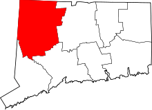 | |
| Towns | ||
| Boroughs | ||
| CDPs |
| |
| Other communities | ||
| Indian reservation | ||
| Topics | |||||||
|---|---|---|---|---|---|---|---|
| States | |||||||
| Major cities | |||||||
| State capitals | |||||||
| Transportation |
| ||||||
| |||||||