New Hartford, Connecticut
| New Hartford, Connecticut | ||
|---|---|---|
| Town | ||
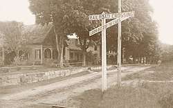 "Central Avenue, New Hartford," a 1910 postcard | ||
| ||
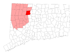 Location in Litchfield County, Connecticut | ||
| Coordinates: 41°50′29″N 73°00′15″W / 41.84139°N 73.00417°WCoordinates: 41°50′29″N 73°00′15″W / 41.84139°N 73.00417°W | ||
| Country |
| |
| U.S. state |
| |
| County | Litchfield | |
| NECTA | Hartford | |
| Region | Northwest Hills | |
| Incorporated | 1738 | |
| Government | ||
| • Type | Selectman-town meeting | |
| • First selectman | Daniel V. Jerram (R) | |
| • Selectman | Alesia R. Kennerson (R) | |
| • Selectman | Eric Claman (I) | |
| Area | ||
| • Total | 38.1 sq mi (98.7 km2) | |
| • Land | 37.0 sq mi (95.9 km2) | |
| • Water | 1.1 sq mi (2.9 km2) | |
| Elevation | 873 ft (266 m) | |
| Population (2010)[1] | ||
| • Total | 6,970 | |
| • Density | 182/sq mi (70/km2) | |
| Time zone | UTC-5 (Eastern) | |
| • Summer (DST) | UTC-4 (Eastern) | |
| ZIP code | 06057 | |
| Area code(s) | 860 | |
| FIPS code | 09-51350 | |
| GNIS feature ID | 0213470 | |
| Website | www.town.new-hartford.ct.us | |
New Hartford is a town in Litchfield County, Connecticut, United States. The population was 6,970 at the 2010 census. The town center is also defined by the U.S. Census Bureau as a census-designated place (CDP). The town is mainly a rural community consisting of farms, homes, and parks. Brodie Park and Ski Sundown are located in New Hartford.
Geography
According to the United States Census Bureau, the town has a total area of 38.1 square miles (99 km2), of which, 37.0 square miles (96 km2) of it is land and 1.1 square miles (2.8 km2) of it (2.91%) is water. The CDP has a total area of 3.5 square miles (9.1 km2) of which 5.80% is water.
Principal communities
- Bakerville
- Nepaug
- New Hartford center
- Pine Meadow (has its own post office)
Demographics
| Historical population | |||
|---|---|---|---|
| Census | Pop. | %± | |
| 1820 | 1,685 | — | |
| 1850 | 2,643 | — | |
| 1860 | 2,758 | 4.4% | |
| 1870 | 3,078 | 11.6% | |
| 1880 | 3,302 | 7.3% | |
| 1890 | 3,160 | −4.3% | |
| 1900 | 3,424 | 8.4% | |
| 1910 | 2,144 | −37.4% | |
| 1920 | 1,781 | −16.9% | |
| 1930 | 1,834 | 3.0% | |
| 1940 | 1,836 | 0.1% | |
| 1950 | 2,395 | 30.4% | |
| 1960 | 3,033 | 26.6% | |
| 1970 | 3,970 | 30.9% | |
| 1980 | 4,884 | 23.0% | |
| 1990 | 5,769 | 18.1% | |
| 2000 | 6,088 | 5.5% | |
| 2010 | 6,970 | 14.5% | |
| Est. 2014 | 6,812 | [2] | −2.3% |
| U.S. Decennial Census[3] | |||
As of the census[4] of 2000, there were 6,088 people, 2,228 households, and 1,748 families residing in the town. The population density was 164.4 people per square mile (63.5/km²). There were 2,368 housing units at an average density of 64.0 per square mile (24.7/km²). The racial makeup of the town was 97.67% White, 0.64% African American, 0.05% Native American, 0.74% Asian, 0.07% Pacific Islander, 0.20% from other races, and 0.64% from two or more races. Hispanic or Latino of any race were 1.35% of the population.
There were 2,228 households out of which 38.3% had children under the age of 18 living with them, 68.9% were married couples living together, 6.6% had a female householder with no husband present, and 21.5% were non-families. 16.4% of all households were made up of individuals and 4.7% had someone living alone who was 65 years of age or older. The average household size was 2.72 and the average family size was 3.07.
In the town, the population was spread out with 26.9% under the age of 18, 4.4% from 18 to 24, 31.0% from 25 to 44, 28.7% from 45 to 64, and 8.9% who were 65 years of age or older. The median age was 39 years. For every 100 females, there were 100.1 males. For every 100 females age 18 and over, there were 97.6 males.
The median income for a household in the town was $69,321, and the median income for a family was $78,065. Males had a median income of $52,077 versus $36,946 for females. The per capita income for the town was $30,429. About 1.5% of families and 1.6% of the population were below the poverty line, including none of those under age 18 and 3.1% of those age 65 or over.
New Hartford Census Designated Place (CDP)
As of the census of 2000, there were 1,049 people, 428 households, and 291 families residing in the CDP. The population density was 322.4 inhabitants per square mile (124.6/km²). There were 451 housing units at an average density of 138.6 per square mile (53.6/km²). The racial makeup of the CDP was 96.09% White, 1.33% African American, 0.10% Native American, 0.57% Asian, 0.10% Pacific Islander, 0.48% from other races, and 1.33% from two or more races. Hispanic or Latino of any race were 3.15% of the population.
There were 428 households out of which 29.4% had children under the age of 18 living with them, 54.0% were married couples living together, 10.5% had a female householder with no husband present, and 31.8% were non-families. 22.9% of all households were made up of individuals and 7.2% had someone living alone who was 65 years of age or older. The average household size was 2.41 and the average family size was 2.86.
In the CDP the population was spread out with 22.3% under the age of 18, 4.9% from 18 to 24, 34.8% from 25 to 44, 25.5% from 45 to 64, and 12.6% who were 65 years of age or older. The median age was 40 years. For every 100 females, there were 102.5 males. For every 100 females age 18 and over, there were 96.9 males.
The median income for a household in the CDP was $53,182, and the median income for a family was $61,389. Males had a median income of $41,522 versus $35,786 for females. The per capita income for the CDP was $28,675. About 6.8% of families and 6.1% of the population were below the poverty line, including none of those under age 18 and 14.8% of those age 65 or over.
Education
The town of New Hartford has three elementary schools: the New Hartford Elementary and Bakerville School have grades Kindegarten through Second Grade. The New Hartford Elementary School includes preschool classes, with most children attend whichever school they're closest to. All children from grades three through six attend the Ann Antolini School. Resident middle and high school students attend the Northwestern Regional District #7, located in Winsted, Connecticut.
Community and recreation
New Hartford is home to Ski Sundown, a locally popular ski mountain that attracts many skiers and snowboarders in Litchfield County. It hosts several Slopestyle Competitions and winter events every year. Many other community events are held at Brodie Park, which lies on the edge of West Hill Lake, where a small beach and swimming area is welcome for New Hartford Residents. Several of the events held at Brodie Park are: The Race Around The Lake, on Memorial Day weekend, several camps and concerts during the summer, a community picnic in July, and an annual children's Christmas Party held in Berkshire Hall. All other events are held in New Hartford Center, primarily the annual Light New Hartford held in early December. New Hartford is the largest town in the local area, and therefore has many of the regional sports teams. Most games for baseball, softball, soccer and football are held at Brown's Corner, which is off Route 202.
Places of worship
There are six churches in New Hartford: two Congregational churches (the oldest church in the town, at New Hartford Center, and another in the village of Nepaug), an Episcopal church (at Pine Meadow), Saint Paul’s Lutheran church, a Methodist church (in the village of Bakerville), and Immaculate Conception Roman Catholic Church. There is also a Buddhist temple, at Bakersville.
Transportation
The town's main thoroughfares are Route 202 and Route 44. Being a primarily rural town, New Hartford does not have any public transit services.
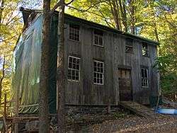
On the National Register of Historic Places
- Philip Chapin House—55 Church Street—An Italian Renaissance house built in 1867
- Esperanza—511 Town Hill Road—A country estate, first built in a Greek Revival style in 1835, then expanded in a Colonial revival style between 1874 and 1893
- Pine Meadow Historic District—A collection of mid to late 18th-century houses built in the Pine Meadow area
- Sun Terrace—Route 219—A country house built in the International style, first completed in 1932.
- Gillette's Grist Mill—Maple Hollow Road—a 19th-century gristmill on the Nepaug River
Notable locations
- Ski Sundown- a ski resort.
- Ovation Guitar Company
- Brewery Legitimus - a 7 barrel craft brewery and taproom
References
- ↑ American FactFinder, Census.gov
- ↑ "Annual Estimates of the Resident Population for Incorporated Places: April 1, 2010 to July 1, 2014". Archived from the original on May 23, 2015. Retrieved June 4, 2015.
- ↑ "Census of Population and Housing". Census.gov. Retrieved June 4, 2015.
- ↑ "American FactFinder". United States Census Bureau. Retrieved 2008-01-31.
External links
| Wikimedia Commons has media related to New Hartford, Connecticut. |
- Town of New Hartford official website
- New Hartford Department Of Recreation
- NewHartfordPlus Online independent community newspaper
- Northwest Connecticut Arts Council
- Northwest Connecticut Convention and Visitors Bureau
- Northwestern Connecticut Community College in Winsted
Municipalities and communities of Litchfield County, Connecticut, United States | ||
|---|---|---|
| Consolidated city | 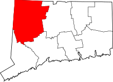 | |
| Towns | ||
| Boroughs | ||
| CDPs |
| |
| Other communities | ||
| Indian reservation | ||
| Topics | |||||||
|---|---|---|---|---|---|---|---|
| States | |||||||
| Major cities | |||||||
| State capitals | |||||||
| Transportation |
| ||||||
| |||||||