Granby, Connecticut
| Granby, Connecticut | ||
|---|---|---|
| Town | ||
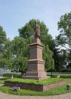 Civil War Soldiers' Monument in the town center | ||
| ||
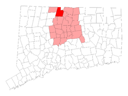 Location in Hartford County, Connecticut | ||
| Coordinates: 41°57′44″N 72°50′22″W / 41.96222°N 72.83944°WCoordinates: 41°57′44″N 72°50′22″W / 41.96222°N 72.83944°W | ||
| Country |
| |
| U.S. state |
| |
| County | Hartford | |
| NECTA | Hartford | |
| Region | Capitol Region | |
| Settled | 1723 | |
| Incorporated | 1786 | |
| Government | ||
| • Type | Board of selectmen-town manager | |
| • First Selectman | Barry Scott Kuhnly (R) | |
| • Selectmen |
Mark C. Neumann (R) Edward E. Ohannessian (R) Sally S. King (D) James Lofink(D) | |
| • Town manager | John D. Ward | |
| Area | ||
| • Total | 40.8 sq mi (105.7 km2) | |
| • Land | 40.7 sq mi (105.4 km2) | |
| • Water | 0.2 sq mi (0.4 km2) | |
| Elevation | 550 ft (167 m) | |
| Population (2010) | ||
| • Total | 11,282 | |
| • Density | 280/sq mi (110/km2) | |
| Time zone | UTC-5 (Eastern) | |
| • Summer (DST) | UTC-4 (Eastern) | |
| ZIP code | 06035, 06060, 06090 | |
| Area code(s) | 860 | |
| FIPS code | 09-32640 | |
| GNIS feature ID | 0213434 | |
| Website |
www | |
Granby is a town in Hartford County, Connecticut, United States. The population was 11,282 at the 2010 census.[1] The town center is defined as a census-designated place known as Salmon Brook. Other areas in town include North Granby and West Granby. Granby is a rural town, located in the foothills of the Litchfield Hills of the Berkshires, besides the suburban natured center, the outskirts of town are filled with dense woods and rolling hills and mountains. From the 1890s to the 1920s a large number of immigrants from Sweden came to reside in the town.
History
Granby was founded by people who lived in Simsbury and settled as early as 1723. Granby was part of Simsbury until 1786, when it became independent.[2] The name is from Granby, Massachusetts in return, where it was named in honor of John Manners, Marquess of Granby.
Part of Southwick, Massachusetts, known as "the Notch" seceded from Massachusetts in 1774, just before the outbreak of the American Revolutionary War. This territory became part of Granby when it seceded from Simsbury, but was returned to Southwick as part of an 1803-4 border dispute compromise. (See History of Massachusetts.)
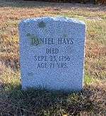
In 1707, Daniel Hayes, then aged twenty-two, was captured by the indigenous people and carried off to Canada. The capture was witnessed, and a rescue party raised, but the group did not catch up with the captors. He was tied up each night, and bound to saplings. It took thirty days to reach Canada, at which point Hayes was forced to run the gauntlet. Near the end of the gauntlet, he hid in a wigwam to avoid an attempted blow by a club. The woman in the wigwam declared that the house was sacred, and having lost a husband and son to a war, adopted Hayes as her son. He remained for several years, attending to the woman. Eventually, he was sold to a Frenchman, who learned that Hayes had skill as a weaver, so put him to work in that business. Hayes managed to earn enough to buy his freedom after two years. He then returned to Simsbury, settled down on a farm and married. He became prominent, both in civil affairs as well as the church at Salmon Brook (now Granby).[3]
The first unauthorized coins minted in the American colonies, and the first in Connecticut, were struck by Dr. Samuel Higley in 1737 from copper mined from his own mine. The coins, including the Trader's Currency Token of the Colony of Connecticut were minted in North Simsbury, now called Granby.[4] These coins were made of pure copper, which is very soft. Consequently, there are very few in existence today. The first coins were inscribed with a value of three pence. Later versions carried the phrase "Value me as you please."[5]
In 1858, the eastern part of the town broke off and formed to become East Granby, the town is one of the newly established town in the state.
In 2009 Connecticut Magazine ranked Granby the #3 overall Connecticut small town (population 10,000-15,000) to live in, and #1 small town in Hartford County.[6]
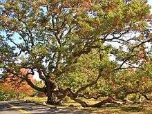
The town seal depicts the Dewey-Granby Oak, a large white oak estimated to be 450–500 years old, thought to be one of the oldest trees in New England.[7]
Geography
According to the United States Census Bureau, the town has a total area of 40.8 square miles (105.7 km2), of which 40.7 square miles (105.4 km2) is land and 0.15 square miles (0.4 km2), or 0.33%, is water.[1] The town center (Salmon Brook CDP) has a total area of 3.0 square miles (7.8 km2), all land. According to Google Earth, the highest point in Granby is 1,153 feet (351 m) in West Granby at 41°55'57.81" N 72°53'17.18" W. The town is covered in dense woodlands containing animals such as the Black Bear, Eastern Moose, and white-tailed deer. Granby gets a lot of snowfall during the winter and is warm during the summer. Snow and cold temperatures are not uncommon in spring and fall due to the town located in The Berkshires
Demographics
| Historical population | |||
|---|---|---|---|
| Census | Pop. | %± | |
| 1820 | 3,012 | — | |
| 1850 | 2,498 | — | |
| 1860 | 1,720 | −31.1% | |
| 1870 | 1,517 | −11.8% | |
| 1880 | 1,340 | −11.7% | |
| 1890 | 1,251 | −6.6% | |
| 1900 | 1,299 | 3.8% | |
| 1910 | 1,383 | 6.5% | |
| 1920 | 1,342 | −3.0% | |
| 1930 | 1,388 | 3.4% | |
| 1940 | 1,544 | 11.2% | |
| 1950 | 2,693 | 74.4% | |
| 1960 | 4,968 | 84.5% | |
| 1970 | 6,150 | 23.8% | |
| 1980 | 7,956 | 29.4% | |
| 1990 | 9,369 | 17.8% | |
| 2000 | 10,347 | 10.4% | |
| 2010 | 11,282 | 9.0% | |
| Est. 2014 | 11,310 | [8] | 0.2% |
| U.S. Decennial Census[9] | |||
As of the census[10] of 2000, there were 10,347 people, 3,781 households, and 2,994 families residing in the town. The population density was 254.3 people per square mile (98.2/km²). There were 3,887 housing units at an average density of 95.5 per square mile (36.9/km²). The racial makeup of the town was 97.54% White, 0.61% African American, 0.23% Native American, 0.74% Asian, 0.02% Pacific Islander, 0.23% from other races, and 0.63% from two or more races. Hispanic or Latino of any race were 1.30% of the population.
There were 3,781 households out of which 39.5% had children under the age of 18 living with them, 71.1% were married couples living together, 5.9% had a female householder with no husband present, and 20.8% were non-families. 16.5% of all households were made up of individuals and 6.8% had someone living alone who was 65 years of age or older. The average household size was 2.71 and the average family size was 3.06.
In the town, the population was spread out with 27.3% under the age of 18, 3.7% from 18 to 24, 30.1% from 25 to 44, 27.8% from 45 to 64, and 11.0% who were 65 years of age or older. The median age was 40 years. For every 100 females, there were 98.7 males. For every 100 females age 18 and over, there were 95.1 males.
The median income for a household in the town was $81,151, and the median income for a family was $90,057. Males had a median income of $63,093 versus $42,203 for females. The per capita income for the town was $33,863. About 1.5% of families and 3.1% of the population were below the poverty line, including 3.6% of those under age 18 and 3.2% of those age 65 or over.
| Voter Registration and Party Enrollment as of October 25, 2005[11] | |||||
|---|---|---|---|---|---|
| Party | Active Voters | Inactive Voters | Total Voters | Percentage | |
| Republican | 2,328 | 138 | 2,466 | 32.10% | |
| Democratic | 1,711 | 82 | 1,793 | 23.34% | |
| Unaffiliated | 3,186 | 219 | 3,405 | 44.32% | |
| Minor Parties | 16 | 2 | 18 | 0.23% | |
| Total | 7,241 | 441 | 7,682 | 100% | |
Education
Granby's public school system consists of one primary school, one intermediate school, one middle school, and one high school.
- Kelly Lane Primary School (Grades: K-2)
- Wells Road Intermediate School (Grades: 3-5)
- Granby Memorial Middle School (Grades: 6-8)
- Granby Memorial High School (Grades: 9-12)
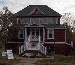
National Register of Historic Places
Notable residents
- Adam Burt (b. 1969), former NHL player, played with the Hartford Whalers
- Joe Bouchard (b. 1948), musician, member of Blue Öyster Cult
- Jesse Camp (b. 1979), MTV VJ
- Chauncey Forward (1793–1839), congressman from Pennsylvania
- Bryan Nash Gill (1961–2013), artist
- Philip C. Hayes (1833–1916), congressman from Illinois
- Byron Kilbourn (1801–1870), surveyor and politician
- Rebecca Lobo (b. 1973), former Women's National Basketball Association player
- Garrett Lucash (b. 1978), figure skater
- Theodore Mills Maltbie (1842-1915), lawyer and politician
- William M. Maltbie (1880–1961), Chief Justice of the Connecticut Supreme Court
- Aaron Draper Shattuck (1832–1928), painter of the White Mountain School
Notes
- 1 2 "Geographic Identifiers: 2010 Demographic Profile Data (G001): Granby town, Hartford County, Connecticut". U.S. Census Bureau, American Factfinder. Retrieved November 26, 2012.
- ↑ Town of Southwick, Massachusetts
- ↑ Phelps, p. 37–44.
- ↑ Federal Writers' Project. Connecticut: A Guide to Its Roads, Lore and People. US History Publishers. p. 58. ISBN 978-1-60354-007-0. Retrieved 23 September 2010.
- ↑ American Numismatic Society (1897). Proceedings of the American Numismatic and Archeological Society. p. 16. Retrieved 20 October 2010.
- ↑ http://www.connecticutmag.com/Connecticut-Magazine/November-2009/Rating-the-Towns-2009-Cities-10000-15000/
- ↑ https://patch.com/connecticut/granby-eastgranby/the-ancient-oak-of-granby
- ↑ "Annual Estimates of the Resident Population for Incorporated Places: April 1, 2010 to July 1, 2014". Archived from the original on May 23, 2015. Retrieved June 4, 2015.
- ↑ "Census of Population and Housing". Census.gov. Archived from the original on May 12, 2015. Retrieved June 4, 2015.
- ↑ "American FactFinder". United States Census Bureau. Archived from the original on 2013-09-11. Retrieved 2008-01-31.
- ↑ "Registration and Party Enrollment Statistics as of October 25, 2005" (PDF). Connecticut Secretary of State. Archived from the original (PDF) on September 23, 2006. Retrieved 2006-10-02.
References
- Phelps, Noah Amherst (1845). History of Simsbury, Granby, and Canton; from 1642 To 1845. Hartford: Press of Case, Tiffany and Burnham.
External links
| Wikimedia Commons has media related to Granby, Connecticut. |
- Town of Granby official website
- Enders Falls in Granby
- McLean Game Refuge
- The Granby Drummer, local monthly newspaper
- Farmington Valley Trails Council
Municipalities and communities of Hartford County, Connecticut, United States | ||
|---|---|---|
| Cities | 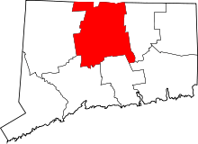 | |
| Towns | ||
| CDPs | ||
| Other communities | ||