Burlington, Connecticut
| Burlington, Connecticut | ||
|---|---|---|
| Town | ||
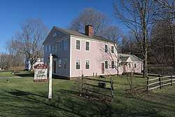 Elton Tavern | ||
| ||
| Motto(s): "A Town Where Community Counts" | ||
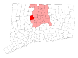 Location within Hartford County, Connecticut | ||
| Coordinates: 41°45′31″N 72°57′28″W / 41.75861°N 72.95778°WCoordinates: 41°45′31″N 72°57′28″W / 41.75861°N 72.95778°W | ||
| Country |
| |
| U.S. state |
| |
| County | Hartford | |
| NECTA | Hartford | |
| Region | Northwest Hills | |
| Incorporated | 1806 | |
| Government | ||
| • Type | Selectman-town meeting | |
| • First Selectman | Ted Shafer[1] | |
| • Selectmen |
James A. Chard (R) David J. Bereza (R) Roger Powell (R) Carl Salsedo (D) | |
| Area | ||
| • Total | 30.4 sq mi (78.8 km2) | |
| • Land | 29.7 sq mi (77.0 km2) | |
| • Water | 0.7 sq mi (1.7 km2) | |
| Elevation | 883 ft (269 m) | |
| Population (2010) | ||
| • Total | 9,301 | |
| • Density | 306.0/sq mi (118.1/km2) | |
| Time zone | UTC-5 (EST) | |
| • Summer (DST) | UTC-4 (EDT) | |
| ZIP code | 06013 | |
| Area code(s) | 860 | |
| FIPS code | 09-10100 | |
| GNIS feature ID | 0213401 | |
| Website |
www | |
Burlington is a town in Hartford County, Connecticut, United States.
Situated at the foot of the Berkshires and bordering the Farmington River, Burlington is a scenic hill town, rural in nature, located 20 miles (32 km) west of Hartford. Incorporated in 1806, the population was 9,301 at the 2010 census.[2] Burlington is home to the State of Connecticut Fish Hatchery, the Nepaug Reservoir and Sessions Woods Wildlife Management Area. Almost half of the land in the town is owned by three public water supply companies and the State of Connecticut.
History
The town was once part of larger Farmington Plantation. In 1785, it split away and became a part of the town of Bristol. In 1806, Burlington separated from Bristol and became a town in its own right.[3]
Geography
According to the United States Census Bureau, the town has a total area of 30.4 square miles (78.8 km2), of which 29.7 square miles (77.0 km2) is land and 0.66 square miles (1.7 km2), or 2.19%, is water.[2]
Demographics
| Historical population | |||
|---|---|---|---|
| Census | Pop. | %± | |
| 1820 | 1,360 | — | |
| 1850 | 1,161 | — | |
| 1860 | 1,031 | −11.2% | |
| 1870 | 1,319 | 27.9% | |
| 1880 | 1,224 | −7.2% | |
| 1890 | 1,302 | 6.4% | |
| 1900 | 1,218 | −6.5% | |
| 1910 | 1,319 | 8.3% | |
| 1920 | 1,109 | −15.9% | |
| 1930 | 1,082 | −2.4% | |
| 1940 | 1,246 | 15.2% | |
| 1950 | 1,846 | 48.2% | |
| 1960 | 2,790 | 51.1% | |
| 1970 | 4,070 | 45.9% | |
| 1980 | 5,660 | 39.1% | |
| 1990 | 7,026 | 24.1% | |
| 2000 | 8,190 | 16.6% | |
| 2010 | 9,301 | 13.6% | |
| Est. 2015 | 9,623 | [4] | 3.5% |
| U.S. Decennial Census[5] | |||
As of the census[6] of 2010, there were 9,326 people, 3,303 households, and 2,691 families residing in the town. The racial makeup of the town was 96.5% White, 0.6% African American, 0.0% Native American, 1.5% Asian, 0.0% Pacific Islander, 0.5% from other races, and 0.9% from two or more races. Hispanic or Latino people of any race were 2.6% of the population.
There were 3,303 households out of which 40.7% had children under the age of 18 living with them, 71.4% were married couples living together, 6.5% had a female householder with no husband present, and 14.5% were non-families. 18.5% of all households were made up of individuals and 5.5% had someone living alone who was 65 years of age or older. The average household size was 2.82 and the average family size was 3.13.
In the town, the population was spread out with 29.0% under the age of 19, 6.4% from 20 to 29, 10.2% from 30 to 39, 20.6% from 40 to 49, 23.7% from 50 to 64, and 5.4% who were 65 years of age or older. The median age was 42.5 years.
Economic figures [7] for the town include a median income for a household at $105,250, and the median income for a family at $114,544. About 2.3% of families have incomes under $15,000/year and 11.9% of families have incomes over $200,000/year.
| Voter registration and party enrollment as of November 1, 2016[8] | |||||
|---|---|---|---|---|---|
| Party | Active voters | Inactive voters | Total voters | Percentage | |
| Republican | 1,907 | 62 | 1,969 | 29.18% | |
| Democratic | 1,719 | 83 | 1,802 | 26.71% | |
| Unaffiliated | 2,699 | 200 | 2,899 | 42.97% | |
| Minor parties | 74 | 3 | 77 | 1.14% | |
| Total | 6,399 | 348 | 6,747 | 100% | |
Schools
Regional School District #10 serves the Connecticut towns of Burlington and Harwinton and was established in 1962. The four schools of the district, Lewis S. Mills High School, Har-Bur Middle School, Lake Garda School and Harwinton Consolidated School, have a total enrollment of more than 2800 students.
Notable locations
- Seventh Day Baptist Cemetery dates back to the late 18th century. It was used as a burial ground for members of the Seventh Day Baptist Church. The cemetery has mistakenly been referred to as "Burlington Center Cemetery" but it is known by locals as Green Lady Cemetery, due to a ghost that purportedly haunts the grounds.
- Whigville (once known as Poverty Hollow[9]) is a village in the southern section of Burlington known for flat, expansive fields and the Grange Hall.
Notable residents
- Samuel Griswold (1790–1867), industrialist born in Burlington
- Leonidas Lent Hamline (1797–1865), Methodist Episcopal bishop and founder of Hamline University; born in Burlington
References
- ↑ http://burlingtonct.us/wp-content/uploads/2010/11/Election-Results-for-November-8.pdf
- 1 2 "Geographic Identifiers: 2010 Census Summary File 1 (G001): Burlington town, Hartford County, Connecticut". American FactFinder. United States Census Bureau. Retrieved April 24, 2017.
- ↑ The Connecticut Magazine: An Illustrated Monthly. Connecticut Magazine Company. 1903. p. 331.
- ↑ "Connecticut Population Estimates as of July 1, 2015 by County and Town" (PDF). Retrieved March 7, 2017.
- ↑ "Census of Population and Housing". Census.gov. Archived from the original on May 12, 2015. Retrieved June 4, 2015.
- ↑ "American FactFinder". United States Census Bureau. Archived from the original on September 11, 2013. Retrieved October 25, 2015.
- ↑ "American FactFinder - SELECTED ECONOMIC CHARACTERISTICS: 2009-2013 American Community Survey 5-Year Estimates". United States Census Bureau. Archived from the original on September 11, 2013. Retrieved October 25, 2015.
- ↑ "Registration and Party Enrollment Statistics as of November 1, 2016" (PDF). Connecticut Secretary of State.
- ↑ http://burlingtonct.us/our-town/history.php
External links
Municipalities and communities of Hartford County, Connecticut, United States | ||
|---|---|---|
| Cities | 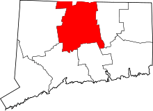 | |
| Towns | ||
| CDPs | ||
| Other communities | ||