Pocumtuck Mountain
- Should not be confused with the Pocumtuck Range (Pocumtuck Ridge) of Deerfield and Greenfield, Massachusetts
| Pocumtuck Mountain | |
|---|---|
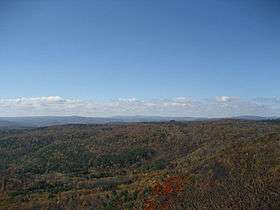 The western view from the summit ledge | |
| Highest point | |
| Elevation | 1,872 ft (571 m) [1] |
| Coordinates | 42°39′07″N 72°46′27″W / 42.65194°N 72.77417°WCoordinates: 42°39′07″N 72°46′27″W / 42.65194°N 72.77417°W [2] |
| Geography | |
 Pocumtuck Mountain Charlemont, Massachusetts, U.S. | |
| Topo map | USGS Heath |
Pocumtuck Mountain, a mountain peak west of the abandoned Catamount settlement, is technically located in Charlemont, Massachusetts. Its summit ledge features wide views of western Franklin County and northern Berkshire County. Pocumtuck Mountain is often confused with the nearby Pocumtuck Range in Deerfield, Massachusetts.
The mountain was named after the Pocumtuc Indians on October 16, 1855 during one of Catamount's Old Homes Days Festival. Such festivals were held often on the scenic mountain - including one visited by Massachusetts Governor John Davis Long.
Except for areas belonging to Catamount State forest, the ledges and surrounding land are privately owned. Trespassing for any reason is not permitted.
References
- ↑ "Pocumtuck Mountain". FranklinSites.com Hiking Guide. Retrieved 2010-10-30.
- ↑ "Pocumtuck Mountain". Geographic Names Information System. United States Geological Survey. Retrieved 2010-10-30.
- Davenport, Elmer. Puzzle of Catamount Hill, 1969.
This article is issued from
Wikipedia.
The text is licensed under Creative Commons - Attribution - Sharealike.
Additional terms may apply for the media files.