Sprague, Connecticut
| Sprague, Connecticut | ||
|---|---|---|
| Town | ||
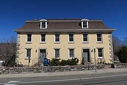 Sprague Public Library | ||
| ||
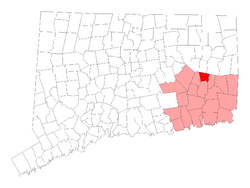 Location within New London County, Connecticut | ||
| Coordinates: 41°37′26″N 72°04′30″W / 41.62389°N 72.07500°WCoordinates: 41°37′26″N 72°04′30″W / 41.62389°N 72.07500°W | ||
| Country | United States | |
| State | Connecticut | |
| NECTA | Norwich-New London | |
| Region | Southeastern Connecticut | |
| Incorporated | 1861 | |
| Government | ||
| • Type | Selectman-town meeting | |
| • First selectman | Cathy Osten (D) | |
| • Selectwoman | Denise E. Dembinski (D) | |
| • Selectwoman | Cheryl A. Blanchard (R) | |
| Area | ||
| • Total | 13.8 sq mi (35.7 km2) | |
| • Land | 13.2 sq mi (34.2 km2) | |
| • Water | 0.6 sq mi (1.6 km2) | |
| Elevation | 276 ft (84 m) | |
| Population (2010) | ||
| • Total | 2,984 | |
| • Density | 220/sq mi (84/km2) | |
| Time zone | UTC-5 (Eastern) | |
| • Summer (DST) | UTC-4 (Eastern) | |
| ZIP code | 06330 | |
| Area code(s) | 860 | |
| FIPS code | 09-71670 | |
| GNIS feature ID | 0213510 | |
| Website |
www | |
Sprague is a town in New London County, Connecticut, United States. The town was named after William Sprague III, who laid out the industrial section.[1] The population was 2,984 at the 2010 census.[2] Sprague is composed of three villages: Baltic, Hanover, and Versailles.
History
In 1856, former Rhode Island Governor and U.S. Senator William Sprague III of Rhode Island laid out plans to build "the largest mill on the Western Continent" in eastern Connecticut, only to die later that year.[3] Sprague's sons constructed the Baltic Cotton Mill on the site, and in 1861 the town was incorporated as the town of Sprague.[3] The mill village of Baltic sat on the Shetucket River in the southwest corner of the town.[3] The original mill burned down in 1877, but the Baltic Power Company continued to operate a mill on the site until 1967.[3]
Geography
According to the United States Census Bureau, the town has a total area of 13.8 square miles (35.8 km²), of which 13.2 square miles (34.2 km²) is land and 0.6 square miles (1.6 km²), or 4.41%, is water.
Principal communities
The town hall is located in Baltic and was constructed in the 1950s.
Demographics
| Historical population | |||
|---|---|---|---|
| Census | Pop. | %± | |
| 1870 | 3,463 | — | |
| 1880 | 3,207 | −7.4% | |
| 1890 | 1,106 | −65.5% | |
| 1900 | 1,339 | 21.1% | |
| 1910 | 2,551 | 90.5% | |
| 1920 | 2,500 | −2.0% | |
| 1930 | 2,539 | 1.6% | |
| 1940 | 2,285 | −10.0% | |
| 1950 | 2,320 | 1.5% | |
| 1960 | 2,509 | 8.1% | |
| 1970 | 2,912 | 16.1% | |
| 1980 | 2,996 | 2.9% | |
| 1990 | 3,008 | 0.4% | |
| 2000 | 2,971 | −1.2% | |
| 2010 | 2,984 | 0.4% | |
| Est. 2014 | 2,980 | [4] | −0.1% |
| U.S. Decennial Census[5] | |||
As of the census[6] of 2000, there were 2,971 people, 1,111 households, and 797 families residing in the town. The population density was 224.8 people per square mile (86.8/km²). There were 1,164 housing units at an average density of 88.1 per square mile (34.0/km²). The racial makeup of the town was 95.42% White, 0.71% African American, 0.64% Native American, 1.35% Asian, 0.07% Pacific Islander, 0.37% from other races, and 1.45% from two or more races. Hispanic or Latino of any race were 1.11% of the population.
There were 1,111 households out of which 36.5% had children under the age of 18 living with them, 54.2% were married couples living together, 12.2% had a female householder with no husband present, and 28.2% were non-families. 21.2% of all households were made up of individuals and 8.8% had someone living alone who was 65 years of age or older. The average household size was 2.63 and the average family size was 3.04.
In the town, the population was spread out with 26.0% under the age of 18, 6.6% from 18 to 24, 32.3% from 25 to 44, 23.4% from 45 to 64, and 11.7% who were 65 years of age or older. The median age was 37 years. For every 100 females, there were 93.0 males. For every 100 females age 18 and over, there were 93.2 males.
The median income for a household in the town was $43,125, and the median income for a family was $57,500. Males had a median income of $40,808 versus $28,616 for females. The per capita income for the town was $20,796. About 2.2% of families and 6.4% of the population were below the poverty line, including 5.1% of those under age 18 and 17.8% of those age 65 or over.
Economy
The previous industry in town was the Baltic Textile Mill, which burned down in 1999.
Ecotourism and events
Sprague is quickly becoming a destination for eco-tourism, having held their first RiverFest, a celebration of the local Shetucket River. The river and festival attract kayakers, canoe enthusiasts, tubers, and nature lovers. A companion festival, the Three Villages Festival, is held each year in October in Baltic, on the public ball field and surrounding area.
Notable people
- Leo Connellan (1928–2001), poet laureate of Connecticut (1996-2001), lived his later years and died in town.[7]
- Charles S. Whitman (1868–1947), judge and the 41st Governor of New York, born in town.
- Glenn Alan Cheney (1951– ), author, selectman (2005-2007).[8]
On the National Register of Historic Places
A historic district and two individual buildings in Sprague are listed on the National Register of Historic Places:
- Ashlawn — 1 Potash Hill Road (added July 4, 1979)
- Baltic Historic District — Roughly bounded by Fifth Avenue, River, High, Main, West Main, and the Shetucket River (added September 3, 1987)
- William Park House — 330 Main Street (added March 7, 2007)
References
- ↑ "Profile for Sprague, Connecticut". ePodunk. Retrieved 2010-05-11.
- ↑ "Profile of General Population and Housing Characteristics: 2010 Demographic Profile Data (DP-1): Sprague town, New London County, Connecticut". U.S. Census Bureau, American Factfinder. Retrieved October 29, 2012.
- 1 2 3 4 "Map of the Baltic Estate in Sprague, Connecticut". Connecticut Historical Society Museum and Library. Connecticut Historical Society. Retrieved 6 May 2018.
- ↑ "Annual Estimates of the Resident Population for Incorporated Places: April 1, 2010 to July 1, 2014". Archived from the original on May 23, 2015. Retrieved June 4, 2015.
- ↑ "Census of Population and Housing". Census.gov. Retrieved June 4, 2015.
- ↑ "American FactFinder". United States Census Bureau. Retrieved 2008-01-31.
- ↑ Press, The Associated (24 February 2001). "Leo Connellan; Connecticut's Poet Laureate, 72". Retrieved 12 April 2018 – via NYTimes.com.
- ↑ "bio". cheneybooks.com. Retrieved 12 April 2018.
External links
Places adjacent to Sprague, Connecticut | |
|---|---|
Municipalities and communities of New London County, Connecticut, United States | ||
|---|---|---|
| Cities |  | |
| Towns | ||
| Boroughs | ||
| CDPs | ||
| Other communities | ||
| Indian reservations | ||
| Footnotes | ‡This populated place also has portions in an adjacent county or counties | |