Sharon, Connecticut
| Sharon, Connecticut | |
|---|---|
| Town | |
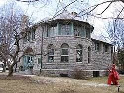 Hotchkiss Memorial Library | |
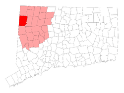 Location in Litchfield County, Connecticut | |
| Coordinates: 41°52′N 73°27′W / 41.867°N 73.450°WCoordinates: 41°52′N 73°27′W / 41.867°N 73.450°W | |
| Country |
|
| U.S. state |
|
| County | Litchfield |
| Region | Northwest Hills |
| Incorporated | 1739 |
| Government | |
| • Type | Selectman-town meeting |
| • First selectman | Brent M. Colley (R) |
| • Selectman | Dale Jones (R) |
| • Selectman | Jessica K. Fowler (D) |
| Area | |
| • Total | 59.6 sq mi (154.4 km2) |
| • Land | 58.7 sq mi (152.0 km2) |
| • Water | 0.9 sq mi (2.2 km2) |
| Elevation | 1,135 ft (346 m) |
| Population (2005) | |
| • Total | 3,052 |
| • Density | 52/sq mi (20/km2) |
| Time zone | UTC−5 (Eastern) |
| • Summer (DST) | UTC−4 (Eastern) |
| ZIP code | 06069 |
| Area code(s) | 860 |
Sharon is a town located in Litchfield County, Connecticut, in the northwest corner of the state. It is bounded on the north by Salisbury, on the east by the Housatonic River, on the south by Kent, and on the west by Dutchess County, New York. At the time of the 2010 census, the town had a total population of 2,782, roughly a third more than it had had 230 years earlier. The ZIP code for Sharon is 06069. The urban center of the town is the Sharon census-designated place, with a population of 729 at the 2010 census.[1]
History
The first inhabitants of the area they called Poconnuck were the Mattabesec Native Americans. These were part of what became known as the Wappinger confederacy which in turn belonged to the loose Algonquian confederacy. Sharon is incorporated in 1739. It is named after the Plain of Sharon.[2]
Historic sites
Sharon has 6 sites listed on the U.S. National Register of Historic Places:
- Ebenezer Gay House, Main St., Sharon
- George King House, 12 N. Main St., Sharon
- Gov. Smith Homestead, South Main St., Sharon
- James Pardee House, 129 N. Main St., Sharon
- Sharon Historic District, roughly Main St. from Low Rd. to its junction with Mitchelltown, Amenia Union, and W. Woods Rds., Sharon
- Sharon Valley Historic District
Geography
According to the United States Census Bureau, the town has a total area of 59.6 square miles (154.3 km²), of which, 58.7 square miles (152.0 km²) of it is land and 0.9 square miles (2.2 km²) of it is water. The total area is 1.44% water. Sharon is part of the Northwest Highlands of Connecticut, a region in and around the watershed of the Housatonic River. The Appalachian Trail passes through a few miles east of Sharon, near West Cornwall and U.S. Route 7.
Principal communities
- Amenia Union
- Ellsworth
- Sharon center
- Sharon Valley
- Main Street & Green
- Calkinstown
- West Woods
Demographics
| Historical population | |||
|---|---|---|---|
| Census | Pop. | %± | |
| 1820 | 2,573 | — | |
| 1850 | 2,507 | — | |
| 1860 | 2,556 | 2.0% | |
| 1870 | 2,441 | −4.5% | |
| 1880 | 2,580 | 5.7% | |
| 1890 | 2,149 | −16.7% | |
| 1900 | 1,982 | −7.8% | |
| 1910 | 1,880 | −5.1% | |
| 1920 | 1,585 | −15.7% | |
| 1930 | 1,710 | 7.9% | |
| 1940 | 1,611 | −5.8% | |
| 1950 | 1,889 | 17.3% | |
| 1960 | 2,141 | 13.3% | |
| 1970 | 2,491 | 16.3% | |
| 1980 | 2,623 | 5.3% | |
| 1990 | 2,928 | 11.6% | |
| 2000 | 2,968 | 1.4% | |
| 2010 | 2,782 | −6.3% | |
| Est. 2014 | 2,725 | [3] | −2.0% |
| U.S. Decennial Census[4] | |||
As of the census[5] of 2000, there were 2,968 people, 1,246 households, and 775 families residing in the town. The population density was 50.6 per square mile (19.5/km²). There were 1,617 housing units at an average density of 27.5 per square mile (10.6/km²). The racial makeup of the town was 96.87% White, 0.94% African American, 0.57% Asian, 0.44% Native American, 0% Pacific Islander, 0.34% from other races, and 0.84% from two or more races. Hispanic or Latino of any race were 1.95% of the population.
There were 1,246 households of which 25.8% had children under the age of 18 living with them, 51.9% were married couples living together, 7.5% had a female householder with no husband present, and 37.8% were non-families. 31.1% of all households were made up of individuals and 13.2% had someone living alone who was 65 years of age or older. The average household size was 2.26 and the average family size was 2.87.
In the town, the population was spread out with 21.3% under the age of 18, 4.2% from 18 to 24, 24.4% from 25 to 44, 29.1% from 45 to 64, and 21.0% who were 65 years of age or older. The median age was 45 years. For every 100 females, there were 94.0 males. For every 100 females age 18 and over, there were 92.2 males.
The median household income was $53,000, and the median family income for a family was $71,458. Males had a median income of $42,841 versus $31,375 for females. The per capita income for the town was $45,418. About 3.9% of families and 7.2% of the population were below the poverty line, including 10.4% of those under the age of 18 and none of those 65 and older.
Education
Sharon is a member of Regional School District 01, which also includes the towns of Canaan, Cornwall, Kent, North Canaan, and Salisbury. Public school students attend Sharon Center School from grades K-8 and Housatonic Valley Regional High School from grades 9-12.
Transportation
The town is served by state highways Route 4, Route 41, Route 343, and Route 361.
Notable residents and natives
- Frank R. Fratellenico (1951-1970) Medal Of Honor Recipient, Vietnam War.
- Kevin Bacon (1958-) and his wife Kyra Sedgwick (1965-) have a house and live part-time in Sharon.
- Patricia Buckley Bozell (1927-2008) was reared in Sharon with her brother,
- William F. Buckley Jr. (1925-2008), at the Buckley family home, "Great Elm".
- Jane Curtin (1947-), actress and comedian, resides in Sharon.
- Michael J. Fox (1961-) and his wife Tracy Pollan (1960-) have a house and live part-time in Sharon.
- Arthur Getz (1913-1996), illustrator best known as the most prolific cover artist of The New Yorker magazine, lived in Sharon.
- Benjamin B. Hotchkiss (1826-1885), a leading 19th-century American ordnance engineer. His widow Maria Bissell Hotchkiss (1827-1901) founded the Hotchkiss Library in Sharon in her husband's memory.
- Jasper Johns (1930-) currently resides in Sharon.
- Elijah Juckett (1760-1839), soldier in the Continental Army.
- Sam Posey (1944-), a retired American racecar driver and sports broadcast journalist, resides in Sharon.
- Campbell Scott (1961-) lives in Sharon.
- Ansel Sterling (1782-1853) was a US Congressman from Connecticut.
- Bradley Whitford (1959-) and his wife Jane Kaczmarek (1955-) had a house and occasionally spent time in Sharon, but after their divorce they stopped returning to the area.
- According to recent published Associated Press news reports, former Witchblade actress, Yancy Butler (1970-) currently resides in Sharon.
- Thomas Hart (1877-1971) retired U.S. Navy Admiral who commanded the Asiatic Fleet at the beginning of World War 2, and after retirement in 1945 served as U.S. Senator from Connecticut until 1946.
The presence of Sharon Hospital, a sizeable regional hospital, has led to Sharon being birthplace to several people who did not live in the town:
- Samuel Berger, U.S. National Security Advisor to President Bill Clinton. Born in Sharon on October 28, 1945, but raised in nearby Millerton, New York.
- Michael Cole (born Michael Shawn Coulthard), announcer on WWE Raw and former journalist with CBS Radio. Born in Sharon on December 8, 1966, but raised in nearby Amenia, New York.
- Philip Amelio, 1980s child actor. Born in Sharon on November 3, 1977, but raised in nearby Pine Plains, New York.
Alfred Korzybski, founder of the nearby Institute of General Semantics, died at Sharon Hospital March 1, 1950.
References
- ↑ https://www.census.gov/prod/cen2010/cph-2-8.pdf
- ↑ The Connecticut Magazine: An Illustrated Monthly. Connecticut Magazine Company. 1903. p. 334.
- ↑ "Annual Estimates of the Resident Population for Incorporated Places: April 1, 2010 to July 1, 2014". Archived from the original on May 23, 2015. Retrieved June 4, 2015.
- ↑ "Census of Population and Housing". Census.gov. Retrieved June 4, 2015.
- ↑ "American FactFinder". United States Census Bureau. Retrieved 2008-01-31.
| Wikimedia Commons has media related to Sharon, Connecticut. |
External links
- Sharon Historical Society
- Historic USGS map including Sharon, in the southwest corner of the quadrangle
- 1935 Description of Sharon
- Housatonic Meadows State Park in Sharon, along the Housatonic River
- Mudge Pond, a 206-acre (834,000 m²) lake located in Sharon
- Sharon Audubon Center
- Northwest Connecticut Arts Council
- Northwest Connecticut Convention and Visitors Bureau
- Northwestern Connecticut Community College in Winsted
Municipalities and communities of Litchfield County, Connecticut, United States | ||
|---|---|---|
| Consolidated city |  | |
| Towns | ||
| Boroughs | ||
| CDPs |
| |
| Other communities | ||
| Indian reservation | ||
| Topics | |||||||
|---|---|---|---|---|---|---|---|
| States | |||||||
| Major cities | |||||||
| State capitals | |||||||
| Transportation |
| ||||||
| |||||||