Sunnyvale, California
| Sunnyvale, California | ||
|---|---|---|
| City | ||
| City of Sunnyvale | ||
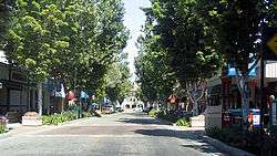 South Murphy Avenue | ||
| ||
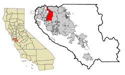 Location in Santa Clara County and the State of California | ||
 Sunnyvale, California Location in the United States | ||
| Coordinates: 37°22′16″N 122°2′15″W / 37.37111°N 122.03750°WCoordinates: 37°22′16″N 122°2′15″W / 37.37111°N 122.03750°W | ||
| Country |
| |
| State |
| |
| County |
| |
| Incorporated | December 24, 1912[1] | |
| Government | ||
| • Type | Council-manager[2] | |
| • Mayor | Glenn Hendricks[2] | |
| • Vice mayor | Larry Klein[2] | |
| • City Manager | Kent Steffens[3] | |
| Area[4] | ||
| • Total | 22.69 sq mi (58.75 km2) | |
| • Land | 21.98 sq mi (56.94 km2) | |
| • Water | 0.70 sq mi (1.82 km2) 3.09% | |
| Elevation[5] | 125 ft (38 m) | |
| Population (2010)[6] | ||
| • Total | 140,081 | |
| • Estimate (2016)[7] | 152,771 | |
| • Rank |
2nd in Santa Clara County 39th in California | |
| • Density | 6,949.51/sq mi (2,683.18/km2) | |
| Time zone | UTC−8 (PST) | |
| • Summer (DST) | UTC−7 (PDT) | |
| ZIP codes | 94085–94090 | |
| Area codes | 408/669 and 650 | |
| FIPS code | 06-77000 | |
| GNIS feature IDs | 1656344, 2412009 | |
| Website |
sunnyvale | |
Sunnyvale (/ˈsʌniveɪl,
Sunnyvale is the seventh most populous city in the San Francisco Bay Area and one of the major cities comprising Silicon Valley. It is bordered by portions of San Jose to the north, Moffett Federal Airfield to the northwest, Mountain View to the northwest, Los Altos to the southwest, Cupertino to the south, and Santa Clara to the east. It lies along the historic El Camino Real and Highway 101.
As part of California's high-tech area known as Silicon Valley, Sunnyvale is the headquarters location of many technology companies and is a major operating center for many more. It is also home to several aerospace/defense companies. Sunnyvale was also the home to Onizuka Air Force Station, often referred to as "the Blue Cube" due to the color and shape of its windowless main building. The facility, previously known as Sunnyvale Air Force Station, was named for the deceased Space Shuttle Challenger astronaut Ellison Onizuka. It served as an artificial satellite control facility of the U.S. military until August 2010 and has since been decommissioned and demolished.
Sunnyvale is one of the few U.S. cities to have a single unified Department of Public Safety, where all personnel are trained as firefighters, police officers, and EMTs, so they can respond to an emergency in any of the three roles.
Library services for the city are provided by the Sunnyvale Public Library, located at the Sunnyvale Civic Center.
History

When the Spanish first arrived in the 1770s at the Santa Clara Valley, it was heavily populated by the Ohlone Native Americans.[9] However early on with the arrival of the Spaniards, smallpox, measles and other new diseases greatly reduced the Ohlone population.[9] In 1777, Mission Santa Clara was founded by Franciscan missionary Padre Junipero Serra and was originally located in San Jose (near what is now the San Jose International Airport runway).[9]
1800s
In 1842, Rancho Pastoria de las Borregas was granted to Francisco Estrada and his wife Inez Castro. Portions of the land given in this grant later developed into the cities of Mountain View and Sunnyvale. Two years later, in 1844, another land grant was provided to Lupe Yñigo, one of the few Native Americans to hold land grants. His land grant was first called Rancho Posolmi, named in honor of a village of the Ohlone that once stood in the area. Rancho Posolmi was later known as Rancho Ynigo.
Martin Murphy Jr. came to California with his father as part of the Stephens-Townsend-Murphy Party in 1844. In 1850, Martin Murphy Jr. bought a piece of Rancho Pastoria de las Borregas for $12,500. Murphy established a wheat farm and ranch named Bay View. Murphy had the first wood frame house in Santa Clara County; it was shipped from New England. The house was demolished in 1961 but was reconstructed in 2008 as the Sunnyvale Heritage Park Museum. When he died in 1884, his land was divided among his heirs.
In 1860, The San Francisco and San Jose Rail Road was allowed to lay tracks on Bay View and established Murphy Station. Lawrence Station was later established on the southern edge of Bay View.
In the 1870s, small fruit orchards replaced many large wheat farms, because wheat farming turned uneconomical due to county and property tax laws, imports and soil degradation.[10] In 1871, Dr. James M. Dawson and his wife Eloise (née Jones) established the first fruit cannery in the county.[10][11] Fruit agriculture for canning soon became a major industry in the county. The invention of the refrigerated rail car further increased the viability of an economy based upon fruit. The fruit orchards became so prevalent that in 1886, the San Jose Board of Trade called Santa Clara County the "Garden of the World".
In the 1880s, Chinese workers made up roughly one third of the farm labor in Santa Clara County.[12] This percentage reduced over time after the Chinese Exclusion Act was passed. In the following decade, the 1890s, many immigrants from Italy, the Azores, Portugal, and Japan arrived to work in the orchards.
In 1897, Walter Everett Crossman bought 200 acres (809,000 m2) and began selling real estate. He advertised the area as "Beautiful Murphy" and later, in the 1900s, as "the City of Destiny". Also in 1897, Encina School opened as the first school in Murphy. Previously, children in the town had to travel to Mountain View for school.
1900s
In 1901, the residents of Murphy were informed they could not use the names Encinal or Murphy for their post office. Sunnyvale was given its current name on March 24, 1901. It was named Sunnyvale as it is located in a sunny region adjacent to areas with significantly more fog.[13]
Sunnyvale continued to grow and in 1904, dried fruit production began. Two years later, Libby, McNeill & Libby, a Chicago meat-packing company, decided to open its first fruit-packing factory in Sunnyvale. Today, a water tower painted to resemble the first Libby's fruit cocktail can label identifies the former site of the factory.
Also in 1906, the Joshua Hendy Iron Works relocated from San Francisco to Sunnyvale after the company's building was destroyed by fire after the 1906 earthquake. The ironworks was the first non-agricultural industry in the town. The company later switched from producing mining equipment to other products such as marine steam engines.
In 1912, the residents of Sunnyvale voted to incorporate, and Sunnyvale became an official city.
Fremont High School first opened in 1923.
In 1930, Congress decided to place the West Coast dirigible base in Sunnyvale. This naval airfield was later renamed Moffett Naval Air Station and then Moffett Federal Airfield and is commonly called Moffett Field.
In 1939, the National Advisory Committee for Aeronautics (NACA, the forerunner of NASA) began research at Ames Laboratory.
During World War II, the war economy began a change from the fruit industry to the high-tech industry in Santa Clara County. The Joshua Hendy Iron Works built marine steam engines, naval guns and rocket launchers to aid in the war effort. As the defense industry grew, a shortage of workers in the farm industry was created. Immigrants from Mexico came to Sunnyvale to fill this void of workers.
Following the war, the fruit orchards and sweetcorn farms were cleared to build homes, factories and offices. In 1956, the aircraft manufacturer Lockheed moved its headquarters to Sunnyvale. Since then, numerous high-tech companies have established offices and headquarters in Sunnyvale, including Advanced Micro Devices and Yahoo. The first prototype of Pong, one of the first arcade videogames, was installed in Sunnyvale in August 1972, in a bar named Andy Capp's Tavern,[14][15] now Rooster T. Feathers.[16] By 2002, the few remaining orchards had been replaced with homes and shops. However, there are still city-owned orchards, such as the Heritage Orchard next to the Sunnyvale Community Center.
In 1979, an indoor mall called Sunnyvale Town Center opened in what used to be a traditional downtown shopping district. After years of successful operation, the mall started to decline in the 1990s. After numerous changes in plans and ownership, the mall was demolished in 2007.
2000s
Sunnyvale celebrated its one-hundredth anniversary on August 25, 2012.
Downtown Development
In November 2009, previously closed portions of the main streets in downtown Sunnyvale were reopened as part of the ongoing downtown redevelopment of the Sunnyvale Town Center mall, marking the first time in over three decades that those street blocks have been open to vehicle and pedestrian traffic. Part of the project involved building new apartment buildings, however during the Great Recession the property was repossessed by Wells Fargo in 2009; the developer countersued, leaving the project in legal limbo through 2015. [17]
The two office buildings are now fully occupied by Apple and Nokia. Mixed-use developments have been built at the former Town and Country location near the Plaza del Sol just north of Murphy Avenue. By mid-2015 new mulitistory apartment complexes had opened, including a number of ground-floor businesses, and the lawsuit against Wells Fargo was resolved in the bank's favor. The development was sold to Sares Regis in late 2016.[18] Redwood Square reopened as a park in 2017.[19] The unfinished apartments are set to be complete and placed for rent in late 2018, with a Whole Foods Market and an AMC Theatres multiplex opening in 2019.[20]
Major Businesses
In the 2010s, Sunnyvale became home to operations from numerous major technology companies, including Apple, LinkedIn (now headquartered in Sunnyvale)[21], Google, Walmart Labs, and 23andMe. Google in particular has announced major development plans in the Moffett Park area, adjacent to Moffett Field.[22]
Geography
Sunnyvale is located at 37°22′7.56″N 122°2′13.4″W / 37.3687667°N 122.037056°W.[23]
According to the United States Census Bureau, the city has a total area of 22.7 sq mi (58.8 km2), of which, 22.0 sq mi (56.9 km2) of it is land and 0.69 sq mi (1.8 km2) of it (3.09%) is water. Its elevation is 130 feet above sea level.
Climate
Like most of the San Francisco Bay Area, Sunnyvale has a Mediterranean climate, with mild, moist winters and comfortably warm, very dry summers. Average daytime summer temperatures are in the high 70s, and during the winter, average daytime high temperatures rarely stay below 50 °F (10 °C). Snowfall is rare, but on January 21, 1962, and February 5, 1976, measurable snowfall occurred in Sunnyvale and most of the San Francisco Bay Area. Sunnyvale was briefly hit by tornados in 1998, but otherwise they are extremely rare.[24][25][26][27]
| Climate data for Sunnyvale, California | |||||||||||||
|---|---|---|---|---|---|---|---|---|---|---|---|---|---|
| Month | Jan | Feb | Mar | Apr | May | Jun | Jul | Aug | Sep | Oct | Nov | Dec | Year |
| Record high °F (°C) | 75 (24) |
84 (29) |
85 (29) |
94 (34) |
100 (38) |
107 (42) |
105 (41) |
101 (38) |
105 (41) |
100 (38) |
89 (32) |
75 (24) |
107 (42) |
| Average high °F (°C) | 58 (14) |
62 (17) |
64 (18) |
69 (21) |
73 (23) |
77 (25) |
79 (26) |
79 (26) |
78 (26) |
73 (23) |
64 (18) |
58 (14) |
70 (21) |
| Average low °F (°C) | 40 (4) |
43 (6) |
46 (8) |
47 (8) |
51 (11) |
55 (13) |
57 (14) |
57 (14) |
55 (13) |
50 (10) |
44 (7) |
39 (4) |
49 (9) |
| Record low °F (°C) | 21 (−6) |
24 (−4) |
22 (−6) |
31 (−1) |
33 (1) |
40 (4) |
41 (5) |
44 (7) |
41 (5) |
34 (1) |
15 (−9) |
20 (−7) |
15 (−9) |
| Average precipitation inches (mm) | 3.24 (82.3) |
3.18 (80.8) |
2.65 (67.3) |
0.89 (22.6) |
0.35 (8.9) |
0.11 (2.8) |
0.03 (0.8) |
0.08 (2) |
0.19 (4.8) |
0.85 (21.6) |
1.83 (46.5) |
2.31 (58.7) |
15.71 (399.1) |
| Source: National Weather Service[28] | |||||||||||||
Demographics
| Historical population | |||
|---|---|---|---|
| Census | Pop. | %± | |
| 1930 | 3,094 | — | |
| 1940 | 4,373 | 41.3% | |
| 1950 | 9,829 | 124.8% | |
| 1960 | 59,898 | 509.4% | |
| 1970 | 95,976 | 60.2% | |
| 1980 | 106,618 | 11.1% | |
| 1990 | 117,229 | 10.0% | |
| 2000 | 131,760 | 12.4% | |
| 2010 | 140,081 | 6.3% | |
| Est. 2016 | 152,771 | [7] | 9.1% |
| U.S. Decennial Census[29] | |||

The 2010 United States Census[30] reported that Sunnyvale had a population of 140,081. The population density was 6,173.9 people per square mile (2,383.8/km2). The racial makeup of Sunnyvale was 60,193 (43.0%) White, 2,735 (2.0%) African American, 662 (0.5%) Native American, 57,320 (40.9%) Asian, 638 (0.5%) Pacific Islander, 12,177 (8.7%) from other races, and 6,356 (4.5%) from two or more races. Hispanic or Latino of any race were 26,517 persons (18.9%). Non-Hispanic Whites were 34.5% of the population in 2010,[31] compared to 74.7% in 1980.[32]
The Census reported that 139,232 people (99.4% of the population) lived in households, 380 (0.3%) lived in non-institutionalized group quarters, and 469 (0.3%) were institutionalized.
There were 53,384 households, out of which 18,614 (34.9%) had children under the age of 18 living in them, 28,583 (53.5%) were opposite-sex married couples living together, 4,629 (8.7%) had a female householder with no husband present, 2,341 (4.4%) had a male householder with no wife present. There were 2,386 (4.5%) unmarried opposite-sex partnerships, and 357 (0.7%) same-sex married couples or partnerships. 13,457 households (25.2%) were made up of individuals and 3,775 (7.1%) had someone living alone who was 65 years of age or older. The average household size was 2.61. There were 35,553 families (66.6% of all households); the average family size was 3.15.
The population was spread out with 31,435 people (22.4%) under the age of 18, 9,350 people (6.7%) aged 18 to 24, 50,919 people (36.3%) aged 25 to 44, 32,721 people (23.4%) aged 45 to 64, and 15,656 people (11.2%) who were 65 years of age or older. The median age was 35.6 years. For every 100 females, there were 101.5 males. For every 100 females age 18 and over, there were 100.9 males.
There were 55,791 housing units at an average density of 2,458.9 per square mile (949.4/km2), of which 25,623 (48.0%) were owner-occupied, and 27,761 (52.0%) were occupied by renters. The homeowner vacancy rate was 1.1%; the rental vacancy rate was 4.4%. 68,895 people (49.2% of the population) lived in owner-occupied housing units and 70,337 people (50.2%) lived in rental housing units.
|
Economy

Largest employers
According to the City's 2017 Comprehensive Annual Financial Report,[34] the top employers in the city are:
| # | Employer | # of Employees |
|---|---|---|
| 1 | Lockheed Martin Space Systems | 4,610 |
| 2 | Apple Inc | 4,000 |
| 3 | Yahoo! Inc | 3,877 |
| 4 | Juniper Networks Inc | 3,180 |
| 5 | 3,176 | |
| 6 | NetApp | 2,209 |
| 7 | A2Z Development Center Inc | 2,021 |
| 8 | 1,840 | |
| 9 | West Valley Staffing | 1,476 |
| 10 | Northrop Grumman Marine Systems | 1,226 |
Government and politics
The mayor and vice-mayor of Sunnyvale are not directly elected. Instead they are selected from the city council members by the city council, serving two-year and one-year terms, respectively.[2]
In the California State Legislature, Sunnyvale is in the 13th Senate District, represented by Democrat Jerry Hill, and in the 24th Assembly District, represented by Democrat Marc Berman.[35]
In the United States House of Representatives, Sunnyvale is in California's 17th congressional district, represented by Democrat Ro Khanna.[36]
As of August 16, 2016, Sunnyvale had 56,030 registered voters.[37]
Education
For elementary and middle schools, most of the city is in the Sunnyvale School District, while some parts are in the Cupertino Union School District and the Santa Clara Unified School District.[38][39]
For high schools, most of the city is in the Fremont Union High School District (the parts that are part of the Sunnyvale School District or Cupertino Union School District for primary schools), and those areas of Sunnyvale are divided between Fremont High School and Homestead High School. Some parts of the city are in the Santa Clara Unified School District.
Neighborhoods
The southern half of Sunnyvale is predominantly residential, while most of the portion of Sunnyvale north of Highway 237 is zoned for industrial use.[40]
Within this southern half are several neighborhoods that account for a large number of Eichler homes throughout residential Sunnyvale. More specifically, there are 16 housing tracts containing over 1100 Eichler homes.[41]
The far eastern section of El Camino Real in Sunnyvale has a significant concentration of businesses owned by Indian immigrants.[42]
Parks
There are 476 acres of parks in the Sunnyvale Area.[43] These include Las Palmas Park, Ortega Park, Seven Seas Park, Washington Park near downtown, two public golf courses, and Baylands Park,[44] site of the annual Linux Picnic.
Charles Street Gardens,[45] Sunnyvale's oldest and largest community garden, is located adjacent to Sunnyvale's Public Library. In 2017 the Santa Clara Unified School District has taken over operation of Full Circle Farm Sunnyvale which leased the land from the district, and plan is under way to focus the farm on education.[46]
Transportation
Several major roads and freeways go through Sunnyvale:
- Central Expressway
- Lawrence Expressway
- State Route 85
- U.S. Route 101
- State Route 237 (Southbay Freeway)
- Interstate 280 (Junipero Serra Freeway)
State Route 82 runs through the center of the city, following the historic El Camino Real.
Public transportation
Sunnyvale is served by Santa Clara Valley Transportation Authority (light rail and buses) and by Caltrain commuter rail. Two Caltrain stations are located in Sunnyvale: the Sunnyvale Station in the Heritage District downtown, and the Lawrence Station in eastern Sunnyvale, north of the Ponderosa neighborhood.
Bicycle
Sunnyvale has been listed by the League of American Bicyclists as a Bicycle Friendly Community at the bronze level.[47]
The Bicycle and Pedestrian Advisory Committee advises the city council on the continued development of the bicycle plan for the city.
Airports
For commercial passenger air travel, Sunnyvale is served by three nearby international airports:
- Norman Y. Mineta San Jose International Airport (SJC), 9.5 miles from downtown Sunnyvale by car. It is also accessible by Caltrain, VTA light rail, and VTA bus. Caltrain and light rail stations require a transfer to a free shuttle bus to get to the airport terminal.
- San Francisco International Airport (SFO), 27.7 miles by car. SFO is transit accessible from Sunnyvale via Caltrain and Bay Area Rapid Transit (BART).
- Metropolitan Oakland International Airport (OAK), 37.5 miles by car. Access to Oakland airport by public transit is possible via multiple transfers.
Crime
Sunnyvale has consistently ranked as one of the safest ten cities (for cities of similar size) in the United States according to the FBI's crime reports. From 1966 to at least 2004, Sunnyvale never placed below fifth in safety rankings among U.S. cities in its population class.[48] In 2005, Sunnyvale ranked as the 18th-safest city overall in the U.S., according to the Morgan Quitno Awards.[49] In 2009, Sunnyvale was ranked 7th in U.S. by Forbes Magazine in an analysis of America's safest cities.[50][51] In 2018, Sunnyvale as named the safest city by SmartAsset.com for the third year in a row.[52]
Folklore
A long-standing legend of Sunnyvale is of a ghost that haunts the town's Toys 'R' Us store. A purported psychic, Sylvia Browne, claimed to have made contact with the ghost on the 1978 TV show That's Incredible! and named him Johnny Johnson. This story was also explored in a 1991 episode of Haunted Lives: True Ghost Stories. Brown stated that he had been a Swedish preacher who worked as a farm hand in the orchard where the toy store now stands and that he bled to death from an accidental, self-inflicted axe injury to his leg.[53][54][55]
Notable people
Arts
- Tony Anselmo, animator and voice of Donald Duck[56]
- Robert Hawkins, artist and painter[57]
Actors
- Ashleigh Aston Moore actress [58]
- Imran Khan, Bollywood actor[59]
- Vaniity, pornographic film actress [60]
Business
- Steve Jobs, co-founder of Apple Inc.[61]
- Lee Pelekoudas, Seattle Mariners interim general manager, raised in Sunnyvale.[62]
- Steve Wozniak, co-founder of Apple Inc.[61]
Criminals
- Richard Farley mass murderer[63]
Filmmakers
- Arthur Davis, Animator and a director[64]
- Timothy Linh Bui, filmmaker [65]
- Tony Bui, film director [66]
- Steve Kloves, American screenwriter, film director and producer
Music
- Antwon, hip-hop artist[67]
- Brian MacLeod, musician[68]
- The Orange Peels, musical group[69]
News and journalism
- Juju Chang, television personality,[70]
Writers
- Martin Ford, entrepreneur, author [71]
- Jeff Goodell, writer[72]
- Michael S. Malone, multiple talents[73]
- Amy Tan, novelist[61]
Sports
- Tully Banta-Cain professional football player[74]
- Brian Boitano, figure skater[56]
- Benny Brown, runner[75]
- Sean Dawkins, NFL player, lived in Sunnyvale[76] while attending Homestead High School in Cupertino.
- Penny Deen, swimmer and coach[56]
- Francie Larrieu-Smith, track and field athlete[74]
- Peter Ueberroth, Major League Baseball Commissioner 1984–89[77]
- Bill Green, former United States Record holder in Track and Field, 5th in the hammer throw at the 1984 Summer Olympics[78]
- Chris Pelekoudas, Major League Baseball umpire, lived and died in Sunnyvale.[62]
- Troy Tulowitzki, Major League Baseball player, graduated from Fremont High School
Scientists
- Andrew Fire, 2006 Nobel Laureate in medicine[61]
- Landon Curt Noll, astronomer, cryptographer and mathematician[79]
Twin towns – sister cities
Until 1970, Sunnyvale had a Sister City relationship with Chillán, Chile. In 2013, the city entered into a three-year Friendly Exchange Relations Agreement with Iizuka, Japan; in July 2016 the city council voted to change this to a Sister City relationship.[80]
See also
References
- ↑ "California Cities by Incorporation Date". California Association of Local Agency Formation Commissions. Archived from the original (Word) on November 3, 2014. Retrieved August 25, 2014.
- 1 2 3 4 "Sunnyvale, CA - City Council". sunnyvale.ca.gov. Retrieved January 26, 2018.
- ↑ "Office of the City Manager". City of Sunnyvale. Retrieved 2018-02-26.
- ↑ "2016 U.S. Gazetteer Files". United States Census Bureau. Retrieved Jun 28, 2017.
- ↑ "Sunnyvale". Geographic Names Information System. United States Geological Survey. Retrieved December 16, 2014.
- ↑ "Sunnyvale (city) QuickFacts". United States Census Bureau. Retrieved August 30, 2016.
- 1 2 "Population and Housing Unit Estimates". Retrieved June 9, 2017.
- ↑ "Heritage Resources and Landmark Alteration Inventory" (PDF). City of Sunnyvale Heritage Preservation Commission. Retrieved 2012-10-07.
- 1 2 3 "Historical Information - Mission Santa Clara de Asís". Santa Clara University. Retrieved 2018-03-27.
- 1 2 "1870-1918, City Expansion". San Jose History. 2013-11-07. Retrieved 2018-03-27.
- ↑ Feroben, Carolyn. "James M. Dawson - Pioneer fruit packer, Santa Clara Valley, 1871". he Valley of Heart's Delight, Santa Clara County Biography Project. Retrieved 2018-03-27.
- ↑ Chan, Sucheng (1989). This Bittersweet Soil: The Chinese in California Agriculture, 1860-1910. Google Books. University of California Press. p. 305. ISBN 0520067371.
- ↑ Capace, Nancy (1999). Encyclopedia of California. North American Book Dist LLC. Page 447. ISBN 9780403093182.
- ↑ "pong [coin-op] arcade video game, atari, inc. (1972)". Arcade-history.com. Retrieved 2014-02-06.
- ↑ Scott Cohen, Zap! The Rise and Fall of Atari, ISBN 0-07-011543-5 (McGraw-Hill, 1984)
- ↑ "City of Sunnyvale Heritage Bicycle Tours" (PDF). Google.com. 2010-11-01. Retrieved 2010-11-09.
- ↑ Sunnyvale Town Center officially for sale as litigation cloud lifts
- ↑ [https://www.bizjournals.com/sanjose/news/2016/09/29/sunnyvale-town-center-deal-closes-for-100-million.html Sunnyvale Town Center deal closes for $100 million ]
- ↑ Redwood Square Opens in Downtown Sunnyvale
- ↑ [https://sunnyvale.ca.gov/business/projects/town.htm CityLine Sunnyvale (formerly Town Center) ]
- ↑ LinkedIn About Us
- ↑ [https://www.mercurynews.com/2018/02/06/googles-sunnyvale-plans-unleash-worries-and-warnings-among-some-merchants/ Google’s Sunnyvale ambitions prompt merchants’ worries and warnings ]
- ↑ "US Gazetteer files: 2010, 2000, and 1990". United States Census Bureau. 2011-02-12. Retrieved 2011-04-23.
- ↑ Sunnyvale and Los Altos, CA Tornadoes, San Francisco State University, Department of Geosciences
- ↑ Hit and Run: Freak tornado injures no one, but leaves behind costly damage,, The Sun (Sunnyvale's Newspaper), May 6, 1998
- ↑ Monteverdi, John P.; Warren Blier; Greg Stumpf; Wilfred Pi; Karl Anderson (November 2001). "First WSR-88D Documentation of an Anticyclonic Supercell with Anticyclonic Tornadoes: The Sunnyvale–Los Altos, California, Tornadoes of 4 May 1998". Monthly Weather Review. American Meteorological Society. 129 (11): 2805. doi:10.1175/1520-0493(2001)129<2805:FWDOAA>2.0.CO;2. Retrieved 2008-12-15.
- ↑ Coile, Zachary; Emily Gurnon (1998-02-06). "Storm knocks out power to thousands in Bay Area; Marin commuters cut off by U.S. 101 closure". THE STORMS OF '98. San Francisco Chronicle. Retrieved 2008-12-15.
- ↑ "Vacation Planner". Weather Channel. Retrieved 2009-05-22.
- ↑ "Census of Population and Housing". Census.gov. Retrieved June 4, 2015.
- ↑ "2010 Census Interactive Population Search: CA - Sunnyvale city". U.S. Census Bureau. Retrieved 2014-07-12.
- ↑ "Sunnyvale (city), California". State & County QuickFacts. U.S. Census Bureau.
- ↑ "California - Race and Hispanic Origin for Selected Cities and Other Places: Earliest Census to 1990". U.S. Census Bureau.
- ↑ "Demographic Profile Bay Area Census". Census.gov. Retrieved 2012-02-06.
- ↑ "Comprehensive Annual Financial Report: For the Fiscal Year Ended June 30, 2017". City of Sunnyvale, California.
- ↑ "Statewide Database". UC Regents. Retrieved November 29, 2014.
- ↑ "California's 17th Congressional District - Representatives & District Map". Civic Impulse, LLC. Retrieved 2013-03-14.
- ↑ "ROV Post-Election Report Aug 16 2016 Special Election" (PDF). sccgov.org. Retrieved 2016-11-28.
- ↑ "Sunnyvale Schools - Sunnyvale California School Ratings - Public and Private". GreatSchools.org.
- ↑ "Index of /geo/maps/dc10map/sch_dist/st06_ca/c06085_santa_clara". United States Census Bureau.
- ↑ City of Sunnyvale Zoning Map, north of 101
- ↑ "Sunnyvale Real Estate | Eichler Homes | Tract Housing | Boyenga Team". siliconvalleyrealestate.com. Retrieved 2014-07-14.
- ↑ A 'Little Madras' here too ..., The Hindu, Online edition of India's National Newspaper, May 2, 2004 (article about the South Indian business district along El Camino Real in Sunnyvale)
- ↑ "City of Sunnyvale: Parks". sunnyvale.ca.gov. Retrieved 2018-05-01.
- ↑ Sunnyvale Department of Parks and Recreation, Park Map
- ↑ "Charles Street Gardens".
- ↑ "Farm at Sunnyvale school will focus on education". San Jose Mercury News. 2017-09-26.
- ↑ "League of American Bicyclists 2016 Bicycle Friendly Communities" (PDF). BikeLeague.org. Retrieved 2016-11-28.
- ↑ City of Sunnyvale News Release No. 11-08, November 22, 2004 Archived February 1, 2015, at the Wayback Machine.
- ↑ Morgan Quitno Awards, 11th Annual America's Safest (and Most Dangerous) Cities Archived December 25, 2011, at the Wayback Machine. (undated)
- ↑ Forbes Magazine, America's Safest Cities
- ↑ Per Forbes, Bay Area Indo American, America's Safest Cities
- ↑ "Sunnyvale named safest city in the U.S. for the third year". The Mercury News. 2018-01-02. Retrieved 2018-08-15.
- ↑ Haunted Toys 'R' Us, snopes.com, January 16, 2007, citing Gina Boubion, Ghost Lets Playful Side Show in Pranks at Haunted Toy Store, The Houston Chronicle, April 26, 1993, p. A2; and Dan Koeppel, Ghost Sightings Aren't Spooking Sales at Toys 'R' Us, Chicago Tribune, June 23, 1991, p. C8
- ↑ Ghost Research Society, Toys 'R Us Ghost
- ↑ Katie Dowd, "Would the death of Toys R Us kill off this famous South Bay ghost story?", San Francisco Chronicle, March 13, 2018.
- 1 2 3 "Who's Who in Santa Clara Unified?". Santa Clara County Unified School District. Archived from the original on 2006-09-28. Retrieved 2017-09-02.
- ↑ "Robert Hawkins Biography". ArtNet.com. Retrieved 2017-09-03.
- ↑ Lentz III, Harris M. (2008). Obituaries in the Performing Arts, 2007: Film, Television, Radio, Theatre, Dance, Music, Cartoons and Pop Culture. McFarland. p. 258. ISBN 0786451912.
- ↑ "Imran Khan: the New Age hero?". Friday. Al Nisr Publishing LLC. Retrieved 2017-09-03.
- ↑ Lawson, Traci (March 16, 2007). "Mexico-born Transsexual Vaniity has obtained many fans". The Canadian. Archived from the original on October 23, 2007. Retrieved October 4, 2017.
- 1 2 3 4 "Centennial Series: Sunnyvale celebrity and the hometown folks who made it big". The Mercury News. 2012-07-12. Retrieved 2017-09-15.
- 1 2 "Mariners' interim GM Lee Pelekoudas: A life in baseball". The Seattle Times. 2008-06-27. Retrieved 2018-06-14.
- ↑ Morain, Dan; Stein, Mark A. (1988-02-18). "Unwanted Suitor's Fixation on Woman Led to Carnage". Los Angeles Times. ISSN 0458-3035. Retrieved 2017-10-05.
- ↑ Lenburg, Jeff (2006). Who's who in Animated Cartoons: An International Guide to Film & Television's Award-winning and Legendary Animators. Hal Leonard Corporation. p. 60. ISBN 155783671X.
- ↑ "Q&A: Vietnamese-American filmmaker Timothy Linh Bui explores his roots and craft". The Mercury News. 2012-11-09. Retrieved 2017-10-05.
- ↑ Bayor, Ronald H. (2011). Multicultural America: An Encyclopedia of the Newest Americans. Santa Barbara, California: ABC-CLIO. p. 2268. ISBN 0313357870.
- ↑ "A First Date With... Antwon". VICE Noisey. Retrieved 2017-07-19.
- ↑ "The Musicians". warningshortfilm.com. Retrieved 2017-10-02.
- ↑ "Harrington: Orange Peels, the Sunnyvale indie-rock band, return with ambitious new album". The Mercury News. 2013-07-19. Retrieved 2017-10-05.
- ↑ "Riots or uprising? 25 years since the Rodney King verdict, a Korean American story". ABC News. 2017-05-01. Retrieved 2017-10-02.
- ↑ "Q&A: Martin Ford, on the robots coming for your job". The Mercury News. 2015-06-12. Retrieved 2017-09-15.
- ↑ Goodell, Jeff (2001). Sunnyvale: The Rise and Fall of a Silicon Valley Family. Vintage. ISBN 0679776389.
- ↑ Cassidy, Mike (December 5, 2013). "Getting to the truth of Silicon Valley". Santa Clara Magazine. Santa Clara University (SCU). Retrieved 2017-10-02.
- 1 2 "Sunnyvale Schools: From Super Bowl rings to Olympic dreams, Fremont High honors its first Hall of Famers". The Mercury News. 2016-01-20. Retrieved 2017-10-05.
- ↑ "Prep Lookout: Los Altos High's class of 1970 was special". The Mercury News. 2015-09-23. Retrieved 2017-10-05.
- ↑ Allen, Percy (June 9, 1999). "Sports: Dawkins Runs A Route From Personal Tragedy". Seattle Times Newspaper. Retrieved 2018-06-14.
- ↑ "Mark Purdy: Peter Ueberroth is the most influential American sports figure of the last 50 years". The Mercury News. 2011-11-08. Retrieved 2017-10-05.
- ↑ "UPI Archives: The 1984 U.S. Olympic Track and Field Team Chosen". UPI Archive. 1984-06-25. Retrieved 2017-10-27.
- ↑ McRae, Steve (2017-07-11). "Landon Curt Noll, computer scientist and 8 world records holder, joins the Great Debate Community". Great Debate Community. Retrieved 2017-10-02.
- ↑ Kezra, Victoria (2016-07-08). "Sunnyvale gains a new sister city in Iizuka, Japan". Sunnyvale Sun. p. 6.
External links
| Wikimedia Commons has media related to Sunnyvale, California. |
| Wikivoyage has a travel guide for Sunnyvale. |
- Official Website
- Sunnyvale, California at Curlie (based on DMOZ)
- Sunnyvale Sun
| Bodies of water |
|  |
|---|---|---|
| Counties | ||
| Major cities | ||
| Cities and towns 100k–250k | ||
| Cities and towns 50k–99k | ||
| Cities and towns 25k-50k | ||
| Cities and towns 10k–25k |
| |
| Sub-regions | ||
Municipalities and communities of Santa Clara County, California, United States | ||
|---|---|---|
| Cities and towns | 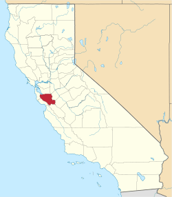 | |
| CDPs | ||
| Unincorporated communities | ||
| CCDs | ||
| Ghost towns | ||
