San Ramon, California
| San Ramon | ||
|---|---|---|
| City | ||
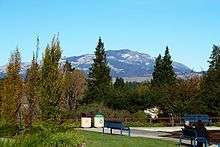
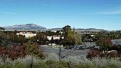 View of San Ramon, at the corner of Bollinger Canyon Rd. and San Ramon Valley Blvd. Mount Diablo is in the background on the left. | ||
| ||
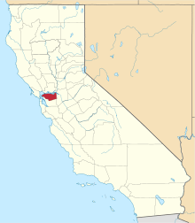
 Location in Contra Costa County and the state of California | ||
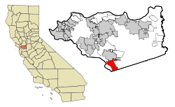
 San Ramon Location in the United States | ||
| Coordinates: 37°46′48″N 121°58′41″W / 37.78000°N 121.97806°WCoordinates: 37°46′48″N 121°58′41″W / 37.78000°N 121.97806°W | ||
| Country | United States | |
| State | California | |
| County | Contra Costa | |
| Incorporated | July 1, 1983[1] | |
| Government | ||
| • Mayor | Bill Clarkson[2] | |
| • State senator | Steve Glazer (D)[3] | |
| • Assemblymember | Catharine Baker (R)[4] | |
| • United States representatives[5] | Mark DeSaulnier (D) and Eric Swalwell (D)[6] | |
| Area[7] | ||
| • Total | 18.64 sq mi (48.29 km2) | |
| • Land | 18.63 sq mi (48.24 km2) | |
| • Water | 0.02 sq mi (0.04 km2) 0.09% | |
| Elevation[8] | 486 ft (148 m) | |
| Population (2010) | ||
| • Total | 72,148 | |
| • Estimate (2017)[9] | 75,931 | |
| • Density | 4,060.72/sq mi (1,567.81/km2) | |
| Time zone | UTC-8 (Pacific) | |
| • Summer (DST) | UTC-7 (PDT) | |
| ZIP codes[10] | 94582, 94583 | |
| Area code | 925 | |
| FIPS code | 06-68378 | |
| GNIS feature IDs | 1656275, 2411805 | |
| Website |
www | |
San Ramon is a city in Contra Costa County, California, United States, located 34 miles east of San Francisco, and within the San Ramon Valley. San Ramon's population was estimated as 75,931 in 2017 by the US Census Bureau,[11] making it the 4th largest city in Contra Costa County, behind Richmond, Concord and Antioch.
San Ramon is home to the headquarters of Chevron, 24-Hour Fitness, the West Coast headquarters of AT&T Inc., the Global Software Center of GE, as well as the San Ramon Medical Center. Major annual events include the Art and Wind Festival on Memorial Day weekend and the Run for Education in October.
On April 24, 2001, San Ramon received the title Tree City USA.[12]
Geography
San Ramon is adjacent to Danville, California, to the north and Dublin, California, to the south. Unincorporated county lands border San Ramon to the east and west. It is located around 500 feet (150 m) above sea level. Mount Diablo flanks the city to the northeast and is prominently visible from almost all parts of the city. The Las Trampas Regional Wilderness borders San Ramon's extreme northwest, at the northern end of Bollinger Canyon. The smaller Bishop Ranch Regional Preserve straddles San Ramon's western border, located approximately between Interstate 680 and the Alameda County line.
The topography of San Ramon is varied, featuring a mix of the rolling hills of the Diablo Range and the flatter basin of the San Ramon Valley. The city is predominantly urban and residential with many new housing developments, however much of the land around the city’s perimeter regions remains undeveloped, and is covered by grasslands and oak tree orchards. During the drier months the grasses are golden; with the precipitation of winter and spring, the grasses turn green, in the late; fall and beginning of winter, some trees with all the leaves all fall off and die, and in the late winter and beginning of spring the leaves start growing.
Climate
San Ramon’s weather typifies a Mediterranean climate, seasonal, and moderate. Summers are warm and dry, while winters are mild, wet and rather short. Its weather is similar to the adjacent cities of Danville, Dublin and Pleasanton. Fog can be infrequent but occurs normally in the western reaches of the city, at the eastern mouth of Crow Canyon, through which marine weather patterns funnel in from the San Francisco Bay via Castro Valley. It usually burns off by mid-to-late morning.
Average January temperatures are a maximum of 58 °F (14 °C) and a minimum of 36 °F (2 °C). Average July temperatures are a maximum of 90 °F (32 °C) and a minimum of 56 °F (13 °C). January is normally the wettest month, averaging 5.20 inches (132 mm) of precipitation and followed by March, is the second wettest month averaging 4.15 inches (105 mm) of precipitation . July is usually the driest month, with an average of only 0.06 inches (1.5 mm) of precipitation. Snow is extremely rare except for Mount Diablo, but hail occurs a few times in the winter.
| Climate data for San Ramon, California | |||||||||||||
|---|---|---|---|---|---|---|---|---|---|---|---|---|---|
| Month | Jan | Feb | Mar | Apr | May | Jun | Jul | Aug | Sep | Oct | Nov | Dec | Year |
| Record high °F (°C) | 73 (23) |
80 (27) |
83 (28) |
97 (36) |
99 (37) |
104 (40) |
103 (39) |
100 (38) |
104 (40) |
103 (39) |
90 (32) |
76 (24) |
104 (40) |
| Average high °F (°C) | 58 (14) |
61 (16) |
63 (17) |
67 (19) |
69 (21) |
73 (23) |
75 (24) |
76 (24) |
76 (24) |
73 (23) |
65 (18) |
59 (15) |
68 (20) |
| Average low °F (°C) | 42 (6) |
43 (6) |
44 (7) |
46 (8) |
49 (9) |
52 (11) |
54 (12) |
55 (13) |
55 (13) |
52 (11) |
45 (7) |
41 (5) |
48 (9) |
| Record low °F (°C) | 26 (−3) |
26 (−3) |
29 (−2) |
30 (−1) |
35 (2) |
41 (5) |
44 (7) |
43 (6) |
41 (5) |
32 (0) |
30 (−1) |
18 (−8) |
18 (−8) |
| Average precipitation inches (mm) | 5.20 (132.1) |
4.80 (121.9) |
4.27 (108.5) |
1.72 (43.7) |
0.71 (18) |
0.15 (3.8) |
0.06 (1.5) |
0.11 (2.8) |
0.36 (9.1) |
1.55 (39.4) |
3.69 (93.7) |
3.84 (97.5) |
26.46 (672.1) |
| Source #1: The Weather Channel [13] | |||||||||||||
| Source #2: MSN Weather [14] | |||||||||||||
History
The lands now occupied by the City of San Ramon were formerly inhabited by Seunen people, an Ohlone/Costanoan group who built their homes near creeks. Sometime around 1797 they were taken by Mission San José for use as grazing land. In 1834, they were part of the Rancho San Ramon land grant to José María Amador.[15]
In 1964, Pacific Air Lines Flight 773 crashed near San Ramon after both pilots were shot by a passenger.[16]
Demographics
| Historical population | |||
|---|---|---|---|
| Census | Pop. | %± | |
| 1880 | 75 | — | |
| 1970 | 4,084 | — | |
| 1980 | 22,356 | 447.4% | |
| 1990 | 35,303 | 57.9% | |
| 2000 | 44,722 | 26.7% | |
| 2010 | 72,148 | 61.3% | |
| Est. 2017 | 75,931 | [9] | 5.2% |
| U.S. Decennial Census[17] | |||
2010 census
The 2010 United States Census[18] reported that San Ramon had a population of 72,148. The population density was 3,991.1 people per square mile (1,541.0/km²). The racial makeup of San Ramon was 38,639 (53.6%) White, 2,043 (2.8%) African American, 205 (0.3%) Native American, 25,713 (35.6%) Asian, 156 (0.2%) Pacific Islander, 1,536 (2.1%) from other races, and 3,856 (5.3%) from two or more races. Hispanic or Latino of any race were 6,250 persons (8.7%).
The Census reported that 72,073 people (99.9% of the population) lived in households, 52 (0.1%) lived in non-institutionalized group quarters, and 23 (0%) were institutionalized.
There were 25,284 households, out of which 11,988 (47.4%) had children under the age of 18 living in them, 16,318 (64.5%) were opposite-sex married couples living together, 1,997 (7.9%) had a female householder with no husband present, 850 (3.4%) had a male householder with no wife present. There were 1,067 (4.2%) unmarried opposite-sex partnerships, and 187 (0.7%) same-sex married couples or partnerships. 4,682 households (18.5%) were made up of individuals and 1,105 (4.4%) had someone living alone who was 65 years of age or older. The average household size was 2.85. There were 19,165 families (75.8% of all households); the average family size was 3.30.
The population was spread out with 21,351 people (29.6%) under the age of 18, 3,557 people (4.9%) aged 18 to 24, 22,798 people (31.6%) aged 25 to 44, 18,815 people (26.1%) aged 45 to 64, and 5,627 people (7.8%) who were 65 years of age or older. The median age was 37.1 years. For every 100 females, there were 96.6 males. For every 100 females age 18 and over, there were 92.4 males.
There were 26,222 housing units at an average density of 1,450.6 per square mile (560.1/km²), of which 25,284 were occupied and 18,056 (71.4%) of them were owner-occupied, and 7,228 (28.6%) were occupied by renters. The homeowner vacancy rate was 1.3%; the rental vacancy rate was 4.0%. 54,705 people (75.8% of the population) lived in owner-occupied housing units and 17,368 people (24.1%) lived in rental housing units.
The median income for a household in the city was $119,297, and the median income for a family was $132,339. Males had a median income of $97,475 versus $70,083 for females. The per capita income for the city was $50,736. About 2.0% of families and 2.8% of the population were below the poverty line, including 2.9% of those under age 18 and 3.5% of those age 65 or over.
|
2000 census
As of the census[20] of 2000, there were 44,722 people, 16,944 households, and 12,148 families residing in the city. The population density was 1,491.1/km² (3,862.0/mi²). There were 17,552 housing units at an average density of 585.2/km² (1,515.7/mi²). The racial makeup of the city was 76.82% White, 1.93% Black or African American, 0.36% Native American, 14.94% Asian, 0.21% Pacific Islander, 2.16% from other races, and 3.58% from two or more races. 7.24% of the population were Hispanic or Latino of any race.
There were 16,944 households out of which 37.9% had children under the age of 18 living with them, 61.8% were married couples living together, 7.0% had a female householder with no husband present, and 28.3% were non-families. 21.1% of all households were made up of individuals and 3.6% had someone living alone who was 65 years of age or older. The average household size was 2.63 and the average family size was 3.12.
In the city, the population was spread out with 26.3% under the age of 18, 5.8% from 18 to 24, 35.7% from 25 to 44, 26.2% from 45 to 64, and 6.1% who were 65 years of age or older. The median age was 36 years. For every 100 females, there were 97.3 males. For every 100 females age 18 and over, there were 94.6 males.
The median income for a household in the city was $95,856, and the median income for a family was $106,321. Males had a median income of $73,502 versus $50,107 for females. The per capita income for the city was $42,336. About 1.4% of families and 2.0% of the population were below the poverty line, including 1.4% of those under age 18 and 4.5% of those age 65 or over.
Government
San Ramon is governed by a four-body City Council composed of individuals elected to four-year overlapping terms in coordination with a two-year elected mayor. On June 30, 2007, police services were provided under contract by the Contra Costa County Sheriff's Department until July 1, 2007, the city officially took over providing police services.
As of 2014, the elected representatives are Bill Clarkson (Mayor), Harry Sachs (Vice Mayor), Scott Perkins, Phil O'Loane and David Hudson (Council members).[21]
The city of San Ramon is in Contra Costa County.
In the United States House of Representatives, the city is split between California's 11th congressional district, represented by Democrat Mark DeSaulnier and California's 15th congressional district, represented by Democrat Eric Swalwell.[6]
Economy


Bishop Ranch, a master-planned office park development, with some retail elements, began major construction in the early 1980s, and provides a healthy tax base for the city. Bishop Ranch is situated on 585 acres once owned by Western Electric, and was farmland before that. Current tenants include the corporate headquarters of Chevron Corporation (formerly ChevronTexaco), as well the West Coast headquarters of AT&T Inc. (which had been the headquarters of Pacific Bell from about 1983, when it relocated from downtown San Francisco, until the merger with SBC Communications that created the current AT&T). United Parcel Service has a regional distribution center in Bishop Ranch. Toyota [22] has a regional office and parts distribution center located there. GE Global Research started its Global Software Center in Bishop Ranch in 2011. Bishop Ranch covers the vast majority of "Central San Ramon", which is the large square formed by Freeway 680 on the west, Crow Canyon Road on the north, Iron Horse trail on the east, and Bollinger Canyon Road on the south (though several complexes are south of Bollinger). In December 2016, the Ligier EZ-10 began use in the first autonomous vehicle passenger shuttle route in North America, looping through Bishop Ranch Office Park, with on-sight operation and maintenance by First Transit.[23]
ChevronTexaco's headquarters moved from San Francisco to San Ramon in 2001 [24] but 12 years later, 800 jobs were moved to Houston, a quarter of the San Ramon workforce due to high corporate costs and to consolidate existing units in Houston.[25]
Largest employers
According to the City's 2012 Comprehensive Annual Financial Report,[26] the top employers in the city are:
| # | Employer | # of Employees | % of Total City Employment |
|---|---|---|---|
| 1 | Chevron | 3,500 | 12.28% |
| 2 | AT&T | 1,753 | 6.15% |
| 3 | Bank of the West | 1,600 | 5.61% |
| 4 | Robert Half International | 1,100 | 3.86% |
| 5 | Accenture | 750 | 2.63% |
| 6 | Pacific Gas & Electric | 604 | 2.12% |
| 7 | San Ramon Regional Medical Center | 500 | 1.75% |
| 8 | GE Digital | 1000 | 1.75% |
| 9 | Primed Management Consulting | 413 | 1.45% |
| 10 | IBM | 408 | 1.45% |
Future downtown
The city of San Ramon is planning a new downtown district. In 2014, the city approved the project’s latest design that calls for an animated civic space featuring 350,000 square feet of quality shops, restaurants and a multiscreen movie theater. At the heart of this development would be a one-acre piazza—open to the sky and lined with trees—for outdoor concerts, art exhibits and other public festivities. A grand opening is eyed for fall 2018.[27]
Education
San Ramon's public schools are part of the San Ramon Valley Unified School District (SRVUSD), serving approximately 30,300 students. The city has 11 elementary schools and 4 middle schools. The high schools are California and Dougherty Valley High School. An alternative K–12 school is operated by the SRVUSD to support home-schooled students: Venture Independent Study School.
California High School was founded in 1973 and ranked 250th best high school in the United States by Newsweek.[28] Dougherty Valley High School is ranked 42nd within California; it is ranked No. 281 in the national rankings and earned a gold medal.[29]
Higher education
- Diablo Valley College – San Ramon branch campus
- University of San Francisco – San Ramon regional campus
- UC Davis Graduate School of Management – the Bay Area working professional program
Public libraries
The San Ramon Library and Dougherty Station Library branches of the Contra Costa County Library are in San Ramon.[30]
Memorial Park

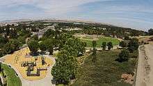
Originally, this city park, located on a hill overlooking Bollinger Canyon Road and San Ramon Valley Blvd., was to be named Alta Mesa Park.[31] During the construction of the park, the City Council voted to change the name to Memorial Park to honor Tom Burnett, a San Ramon resident, and other victims from Flight 93 killed in the September 11 attacks of 2001. A plaque was installed at the base of a lighted flagpole dedicated to those victims and the surrounding meadow is part of the city’s memorial tree program dedicated to local residents who have perished. The park was dedicated on September 11, 2002.[32]
This 16-acre park includes a play area, a BMX course, a picnic area, a bocce ball court, horseshoe courts, a ball field, a dog park, rest rooms and water fountains (including a doggy water fountain). The play area has two big play structures, one for ages 2–5 and another for ages 5–12.[33][34]
Points of interest
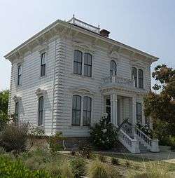
- Museums and historic sites
- Forest Home Farms, National Register of Historic Places
- Parks
- Athan Downs Park
- Bellingham Square Park
- Bollinger Canyon School Park
- Boone Acres Park
- Centennial Park
- Compass Point Park
- Country Club School Park
- Country Fair Park
- Coyote Creek School Park
- Coyote Crossing Park
- Crow Canyon Gardens
- East Branch Park
- Golden View School Park
- Hidden Crest Park
- Hidden Hills School Park
- Memorial Park
- Mill Creek Hollow
- Monarch
- Montevideo School Park
- Neil Armstrong School Park
- Old Ranch Park
- Piccadilly Square Park
- Pine Valley School Park
- Ramona Park
- Rancho San Ramon Community Park
- Red Willow Park
- San Ramon Central Park
- Senior Center Park
- Souyen Park
- Valley View Park
- Village Green Park
- Walt Disney School Park
Transportation
Local bus service in the San Ramon Valley is provided primarily by County Connection (Central Contra Costa Transit Authority, or CCCTA). Ride-sharing services such as Uber and Lyft are also accessible within San Ramon.
The major freeway in the area is Interstate 680.
Notable people
- David Bingham, MLS player for San Jose Earthquakes[35][36]
- Tom Burnett, passenger on United Airlines Flight 93
- Austin Hooper, professional football player
- Marv Hubbard, retired professional American football player
- James Jones, professional football player
- Khalil Mack, professional football player
- Auston Matthews, NHL player for the Toronto Maple Leafs
- Tiffany Roberts, U.S. soccer player
- Tony Stewart, former professional American football player
- John S. Watson, current CEO of Chevron
- Andrew Wiedeman, former professional soccer player [37]
Places adjacent to San Ramon, California | |
|---|---|
See also
References
- ↑ "California Cities by Incorporation Date". California Association of Local Agency Formation Commissions. Archived from the original (Word) on November 3, 2014. Retrieved March 27, 2013.
- ↑ "City Council". City of San Ramon. Retrieved March 27, 2013.
- ↑ "Senators". State of California. Retrieved March 27, 2013.
- ↑ "Members Assembly". State of California. Retrieved March 27, 2013.
- ↑ "Communities of Interest - City". California Citizens Redistricting Commission. Retrieved September 27, 2014.
- 1 2 "California's 11th Congressional District - Representatives & District Map". Civic Impulse, LLC.
- ↑ "2016 U.S. Gazetteer Files". United States Census Bureau. Retrieved Jun 28, 2017.
- ↑ "San Ramon". Geographic Names Information System. United States Geological Survey. Retrieved November 3, 2014.
- 1 2 "https://factfinder.census.gov/faces/tableservices/jsf/pages/productview.xhtml?src=CF". Retrieved October 1, 2018. External link in
|title=(help) - ↑ "ZIP Code(tm) Lookup". United States Postal Service. Retrieved November 23, 2014.
- ↑ "Annual Estimates of the Resident Population: April 1, 2010 to July 1, 2017". www.census.gov. Retrieved October 1, 2018.
- ↑ "City Council Agenda". City of San Ramon. April 24, 2001. Archived from the original on August 15, 2004.
- ↑ "Average Weather for San Ramon, CA - Temperature and Precipitation". The Weather Channel. Retrieved October 31, 2010.
- ↑ "Monthly Averages for San Ramon, California". iMap. Retrieved October 31, 2010.
- ↑ "History of San Ramon". The City of San Ramon. Retrieved March 23, 2015.
- ↑ "Investigations: Death Wish". Time. November 6, 1964. Retrieved March 10, 2018.
- ↑ "Census of Population and Housing". Census.gov. Retrieved June 4, 2015.
- 1 2 "2010 Census Interactive Population Search: CA - San Ramon city". U.S. Census Bureau. Retrieved July 12, 2014.
- ↑ "City of San Ramon". Bayareacensus.ca.gov. Retrieved May 29, 2017.
- ↑ "American FactFinder". United States Census Bureau. Retrieved January 31, 2008.
- ↑ "City Council". City of San Ramon. Retrieved December 20, 2014.
- ↑ "California". Toyota In Action. Archived from the original on December 3, 2013. Retrieved November 26, 2013.
- ↑ "First Transit Announces First Autonomous Passenger Shuttle Pilot in North America with EasyMile". First Transit. December 16, 2016. Retrieved December 18, 2016.
- ↑ "Chevron Press Release – Chevron Moving Corporate Headquarters To San Ramon, Calif". Chevron.com. September 5, 2001. Retrieved November 26, 2013.
- ↑ "Chevron relocating 800 workers from San Ramon to Texas | abc7news.com". Abclocal.go.com. December 21, 2012. Retrieved November 26, 2013.
- ↑ City of San Ramon 2012 Comprehensive Annual Financial Report Retrieved July 18, 2013
- ↑ "San Ramon City Center Update". www.ci.san-ramon.ca.us. March 15, 2017. Retrieved May 29, 2017.
- ↑ "Newsweek rankings of the top US high schools". Newsweek. June 19, 2011. Archived from the original on June 23, 2011. Retrieved July 24, 2011.
- ↑ "US News Best Schools: Dougherty Valley in San Ramon, CA". U.S. News & World Report. Retrieved November 26, 2016.
- ↑ San Ramon Library. Contra Costa County Library. Retrieved on April 1, 2010.
- ↑ "General Plan 2030 Land Use, Traffic & Circulation, and Safety Elements (p. 44)" (PDF). City of San Ramon. Retrieved February 9, 2014.
- ↑ "Minutes of the City of Sam Ramon – Council Meeting". May 14, 2002. Archived from the original on August 12, 2007.
- ↑ "Memorial Park, San Ramon, California". great-kids-parks.com. Retrieved May 29, 2017.
- ↑ "City Parks". City of San Ramon. Retrieved May 29, 2017.
- ↑ "California Golden Bears". David Bingham Profile. calbears. Archived from the original on December 17, 2012. Retrieved April 29, 2013.
- ↑ "Pleasanton's David Bingham, Goalkeeper for the San Jose Earthquakes, Could be Going to 2012 Olympics". Dublin Patch. Archived from the original on June 30, 2013. Retrieved April 29, 2013.
- ↑ Eiges, Brandon (February 5, 2010). "Alumnus turns pro in soccer". The Californian. p. A1.
External links
| Bodies of water |
|  |
|---|---|---|
| Counties | ||
| Major cities | ||
| Cities and towns 100k–250k | ||
| Cities and towns 50k–99k | ||
| Cities and towns 25k-50k | ||
| Cities and towns 10k–25k |
| |
| Sub-regions | ||