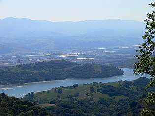
Anderson Lake (California)
| Anderson Lake | |
|---|---|
 April 2008 | |
| Location | Santa Clara County, California |
| Coordinates | 37°10′17″N 121°37′10″W / 37.17139°N 121.61944°WCoordinates: 37°10′17″N 121°37′10″W / 37.17139°N 121.61944°W[1] |
| Type | reservoir |
| Primary inflows | Coyote Creek[2] |
| Primary outflows | Coyote Creek[2] |
| Catchment area | 194.4 sq mi (503 km2) |
| Basin countries | United States |
| Managing agency | Santa Clara Valley Water District |
| Max. length | 41,184 ft (12,553 m) |
| Max. width | 3,840 ft (1,170 m) |
| Surface area | 1,271 acres (5,140,000 m2) |
| Water volume | 91,300 acre feet (112,600,000 m3) |
| Surface elevation | 627 feet (191 m) |
| References | [3][4][1][2] |
Anderson Lake, informally called Anderson Reservoir, is an artificial lake in Santa Clara County, California, United States, near Morgan Hill. A 4,275-acre (1,730 ha) county park surrounds the reservoir[5] and provides limited fishing[6][7] ("catch and release"), picnicking, and hiking activities. Although swimming is prohibited,[8] boating, water-skiing and jet-skiing are permitted in the reservoir.[9]
History
The reservoir was created in 1950 by the construction of the Anderson Dam[10] across Coyote Creek in foothills of the Diablo Mountains east of Morgan Hill. The reservoir and dam were named after Leroy Anderson, a key founder and first president of the Santa Clara Valley Water District. It is the largest reservoir owned by the district.[11]
Anderson Dam
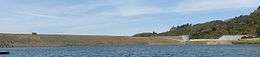
The 235 feet (72 m) high earthen dam measures 1,430 feet (440 m) long by 900 feet (270 m) wide and sits along the Coyote Creek Fault on Coyote Road, east of Morgan Hill.[12] The reservoir itself is situated parallel to the Calaveras Fault, which runs from Hollister to Milpitas.[13] It holds over 90,000 acre feet (110,000,000 m3) of water when full, more than the other nine reservoirs in the county combined.[4]
Risk of dam failure
In January 2009, a preliminary routine seismic study suggested a small chance that a large-magnitude earthquake (6.6 with the dam at the epicenter, or 7.2 up to a mile away) could result in flooding in Morgan Hill and as far away as San Jose. In response, the Santa Clara Valley Water District (SCVWD) lowered the water level to 74 percent of capacity and announced further analysis of the situation, which could possibly result in retrofitting the dam if necessary.[14] Updated findings in October, 2010 indicated that the dam could fail if a magnitude 7.25 earthquake occurred within 2 kilometres (1.2 mi) of the dam, potentially releasing a wall of water 35 feet (11 m) high into downtown Morgan Hill in 14 minutes, and 8 feet (2.4 m) deep into San Jose within three hours.[15] In response SCVWD has lowered the water to 54% full, which is 60 feet (18 m) feet below the dam crest.[16]
In July 2011, SCVWD issued a report stating that the seismic stability study on Anderson Dam was completed. The storage restriction that has been in place since October 2010 was adjusted, allowing 12 additional feet of storage, which measures 68 percent of the dam's capacity, up from 57 percent. The water district has initiated a capital project for a seismic retrofit by the end of 2018. The operating restriction will remain in place until the project is completed.[17] According to the SCVWD, remediation of the problem will cost as much as US$100 million.[15]
In December 2016, SCVWD reported that further geotechnical analysis indicated considerably more work would need to be performed on the dam, effectively removing the dam completely and rebuilding it. The existing dam had been built on alluvial deposits, which could liquefy during an earthquake. Accordingly, the estimated cost rose to US$400 million and the start of work was rescheduled to 2020, with completion planned for 2023–2024.[18]
San Jose flooding
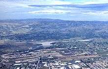
On February 21, 2017 during the 2017 California floods, the reservoir reached as high as 104% of capacity, creating a large flow over the spillway into Coyote Creek, which overflowed and flooded the Rock Springs/Summerside, Olinder, Naglee Park, Roosevelt, Wooster-Tripp and Berryessa neighborhoods of San Jose along US Highway 101 between the reservoir and the south San Francisco Bay.[19]
Anderson Lake County Park
The 4,275-acre (1,730 ha) Anderson Lake County Park is managed by the Santa Clara County Parks and Recreation Department. Features in addition to the county's largest reservoir are the Coyote Creek Parkway multiple use trails, the Jackson Ranch historic park site, the Moses L. Rosendin Park, the Burnett Park area, and Anderson Lake Visitors Center. Coyote Creek Parkway, a paved trail along Coyote Creek that heads 15 miles (24 km) north to Hellyer County Park, is used for hiking, jogging, bicycling, horseback riding, and skating.
See also
References
- 1 2 "Anderson Lake". Geographic Names Information System. United States Geological Survey.
- 1 2 3 "Coyote Creek". Geographic Names Information System. United States Geological Survey.
- ↑ "Listing of Jurisdictional Dams in California" (PDF). California Department of Water Resources. Retrieved July 3, 2017.
- 1 2 Santa Clara Valley Water District. "Fun Facts about the Anderson Dam and Reservoir" (PDF). Retrieved 2017-07-06.
- ↑ "Anderson Lake County Park. Parks and Recreation. County of Santa Clara". County of Santa Clara. Retrieved 2014-09-06.
- ↑
"Santa Clara County Parks: Fishing Guidelines". County of Santa Clara. Retrieved 2017-07-02.
Mercury has been found to accumulate in Almaden, Calero, Guadalupe, Anderson and Stevens Creek Reservoirs at levels that make the fish unsafe to eat.
- ↑
Santa Clara County Parks and Recreation Department. "Mercury and PCBs Found In County Reservoirs". Retrieved 2017-07-05.
... fish sampled from Anderson and Stevens Creek reservoirs-as well as from eight other reservoirs in the Bay Area-exceeded human health guidelines for methylmercury, an organic form of mercury, and for polychlorinated biphenyls, or PCBs, a group of industrial chemicals.
- ↑
"Santa Clara Valley Water District: Recreation Restrictions". Retrieved 2017-07-04.
Swimming at Almaden, Coyote, Anderson and Calero reservoirs is prohibited by the state Department of Health to protect the drinking water supply from potential bacteriological contamination.
- ↑
"Santa Clara County Parks: Boating Guidelines". County of Santa Clara. Retrieved 2017-07-03.
Boating is permitted from 8am to ½ hour before sunset in the following reservoirs: Calero, Coyote Lake, Anderson, Stevens Creek and Lexington.
- ↑ Santa Clara Valley Water District. "Anderson Dam and Reservoir". Retrieved 2014-05-20.
- ↑ "Santa Clara Valley Water District: List of Reservoirs". Retrieved 2017-07-03.
- ↑ Santa Clara Valley Water District. "Anderson Dam Seismic Retrofit (2016 Update Presentation)". Retrieved 2017-07-06.
- ↑ CC Cartography, Inc. "San Jose area faults map". Retrieved 2017-07-06.
- ↑ Rogers, Paul (2009-01-05). "New study shows massive earthquake could cause Anderson Dam to fail". San Jose Mercury News.
- 1 2 Gonzales, Sandra (2010-10-13). "Study: Santa Clara County's Anderson Dam at risk of collapse in major earthquake". San Jose Mercury News. Retrieved 2010-10-29.
- ↑ Grimes, Marty (2010-10-13). Preliminary findings indicate Anderson Dam needs seismic retrofit (Report). Santa Clara Valley Water District. Archived from the original on 12 November 2010. Retrieved 2010-10-29.
- ↑ Grimes, Marty (2011-07-06). Final Anderson Dam seismic study concludes that storage restrictions can be modified but dam must be retrofitted (Report). Santa Clara Valley Water District. Retrieved 2011-07-26.
- ↑ Forstner, Scott (2017-01-18). "Anderson retrofit project cost jumps to $400m". Morgan Hill Times. Retrieved 2017-01-19.
- ↑ Pero, Aaron (February 22, 2017). "Water from Anderson Reservoir to blame for San Jose flooding". San Jose Mercury News. Retrieved 12 March 2017.
External links
- Waterfall during the 2017 California floods