Alameda, California
| Alameda, California | |||
|---|---|---|---|
| City in California | |||
| City of Alameda | |||
_2.JPG) City Hall | |||
| |||
| Nickname(s): The Island City[1] | |||
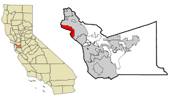 Location in the state of California and Alameda County | |||
 Alameda, California Location in the United States | |||
| Coordinates: 37°45′22″N 122°16′28″W / 37.75611°N 122.27444°WCoordinates: 37°45′22″N 122°16′28″W / 37.75611°N 122.27444°W | |||
| Country |
| ||
| State |
| ||
| County |
| ||
| Founded Incorporated |
June 6, 1853 March 7, 1872[2] | ||
| Government | |||
| • Type | Council–manager | ||
| • Mayor | Trish Herrera Spencer[3] | ||
| • State senator | Nancy Skinner (D)[4] | ||
| • Assemblymember | Rob Bonta (D)[5] | ||
| • U. S. rep. | Barbara Lee (D)[6] | ||
| Area[7] | |||
| • Total | 23.10 sq mi (59.82 km2) | ||
| • Land | 10.44 sq mi (27.05 km2) | ||
| • Water | 12.66 sq mi (32.78 km2) 53.79% | ||
| Elevation[8] | 33 ft (10 m) | ||
| Population (2010) | |||
| • Total | 73,812 | ||
| • Estimate (2017)[9] | 79,177 | ||
| • Density | 7,582.55/sq mi (2,927.55/km2) | ||
| Demonym(s) | Alamedan, Islander | ||
| Time zone | UTC−8 (Pacific) | ||
| • Summer (DST) | UTC−7 (PDT) | ||
| ZIP codes[10] | 94501, 94502 | ||
| Area code | 510 | ||
| FIPS code | 06-00562 | ||
| GNIS feature IDs | 277468, 2409669 | ||
| Website |
alamedaca | ||
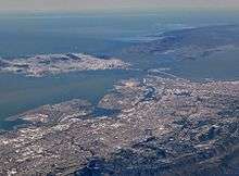
Alameda (/ˌæləˈmiːdə/ AL-ə-MEE-də; Spanish: [ala'meða]) is a city in Alameda County, California, United States. It is located on Alameda Island and Bay Farm Island, and is adjacent to and south of Oakland and east of San Francisco across the San Francisco Bay. Bay Farm Island, a portion of which is also known as "Harbor Bay Isle", is not actually an island, and is part of the mainland adjacent to the Oakland International Airport. The city's estimated 2017 population was 79,928.[11] Alameda is a charter city, rather than a general law city, allowing the city to provide for any form of government. Alameda became a charter city and adopted a council–manager government in 1916, which it retains to the present.
History
Early history and settlement
The island Alameda occupies what was originally a peninsula connected to Oakland. Much of it was low-lying and marshy, but on higher ground than the peninsula and adjacent parts of what is now downtown Oakland were home to one of the largest coastal oak forests in the world. The area was therefore called Encinal, Spanish for "forest of evergreen oak".[12] Alameda is Spanish for "grove of poplar trees" or "tree-lined avenue",[13] and was chosen in 1853 by popular vote.[14]
The inhabitants at the time of the arrival of the Spanish in the late 18th century were a local band of the Ohlone tribe. The peninsula became part of the vast Rancho San Antonio granted in 1820 to Luis Peralta by the Spanish king who claimed California. The grant was later confirmed by the new Republic of Mexico upon its independence from Spain.
Over time, the place became known as Bolsa de Encinal or Encinal de San Antonio.[15]
City development
The city was founded on June 6, 1853, and the town originally contained three small settlements. "Alameda" referred to the village at Encinal and High Streets, Hibbardsville was at the North Shore ferry and shipping terminal, and Woodstock was on the west near the ferry piers of the South Pacific Coast Railroad and the Central Pacific. Eventually, the Central Pacific's ferry pier became the Alameda Mole, featuring transit connections between San Francisco ferries, local trollies and Southern Pacific (formerly Central Pacific) commuter lines.
The first post office opened in 1854.[15] The first school, Schmermerhorn School, was opened in 1855 (and eventually became Lincoln School), Encinal School was opened in 1860 (and closed in 1980). The San Francisco and Alameda Railroad opened the Encinal station in 1864.[15] The Encinal area was also known as Fasskings Station in honor of Frederick Louis Fassking.[15] Encinal's own post office opened in 1876, was renamed West End in 1877, and closed in 1891.[15] The West End area was originally called Bowman's Point in honor of Charles G. Bowman, an early settler.[15]
The Alameda Terminal was the site of the arrival of the first train via the First Transcontinental Railroad into the San Francisco Bay Area on September 6, 1869. The transcontinental terminus was switched to the Oakland Mole two months later, on November 8, 1869.
The borders of Alameda were made coextensive with the island in 1872, incorporating Woodstock into Alameda.[15] Mark Twain described Alameda as being "The Garden of California." [16]
Neptune Beach
In 1917, an attraction called Neptune Beach was built in the area now known as Crab Cove. Often compared to Coney Island, the park was a major attraction in the 1920s and 1930s. The original owners of the facility, the Strehlow family, partnered with a local confectioner to create tastes unique to Neptune Beach. Both the American snow cone[17] and the popsicle[18] were first sold at Neptune Beach. The Kewpie doll, hand-painted and dressed in unique hand-sewn dresses, became the original prize for winning games at the beach – another Neptune Beach invention.[19][20] The Strehlows owned and operated the beach on their own, even filling in a section of the bay to add an additional Olympic-size swimming pool and an exceptional roller coaster which must have given riders a tremendous view of the bay. The Cottage Baths were available for rent.
Neptune Beach's two huge outdoor pools hosted swimming races and exhibitions by such famous swimmers as Olympian Johnny Weissmuller, who later starred as the original Tarzan, and Jack LaLanne, who started a chain of health clubs. The park closed down in 1939 because of the Great Depression, the completion of the San Francisco–Oakland Bay Bridge, people circumventing paying the admission price, and the rise of car culture. Once the Bay Bridge was complete, the rail lines, which ran right past the entrance to Neptune Beach on the way to the Alameda Mole and the Ferry, lost riders in droves. People began using their cars to escape the city and the immediate suburbs like Alameda and traveling further afield in California. Alameda lost its resort status as more distant locations became more attractive to cash-rich San Francisco tourists. Youngsters in town became aware of ways to avoid paying the dime for admission to the park. Strong swimmers or even waders could sneak in on the bay side just by swimming around the fence.
Some of the resort homes and buildings from the Neptune beach era still exist in present-day Alameda. The Croll Building, on the corner of Webster Street and Central Avenue, was the site of Croll's Gardens and Hotel, famous as training quarters for some of the greatest fighters in boxing history from 1883 to 1914. James J. Corbett, Bob Fitzsimmons, Jim Jefferies, Jack Johnson, and many other champions all stayed and trained here. Today this beautifully preserved building is home to Croll's Pizza and the 1400 Bar & Grill Restaurant. Neptune Court, just a block away on the corner of Central Ave. and McKay Ave., provides another glimpse of what resort life was like in Alameda in the 1920s. A short walk near Crab Cove will reveal many more historic gems.
The vast majority of the Neptune Beach structures – the hand-carved carousel from the world-famed Dentzel Company, the Ferris wheel, the roller coaster, and other rides – were auctioned off in 1940 for mere pennies on the dollar of their original cost. Today, A consequence of the Neptune Beach closing around 1940 was a total dearth of quality, clean swimming facilities in town. A grass roots effort to create swimming pools at two high schools and two city parks would continue into the early 1960s.
Transportation

When the railroad came to town in the 1860s Park Street developed into the major thoroughfare of the city and the location of the main Alameda train station, residents of Old Alameda pulled up stakes and moved across town to the new downtown. The street's location was chosen by two landowners who wished to attract tenants and development to their land. As a result, they designated their mutual property line as Park Street.
The need for expanded shipping facilities and flow through the estuary led to the dredging of a canal through the marshland between Oakland and Alameda. Construction started in 1874, but wasn't completed until 1902, when Alameda became an island.[21] Most of the soil from the canal was used to fill in nearby marshland. The area of Alameda called Bay Farm Island is no longer an island, but is attached by fill to Oakland. In his youth, author Jack London was known to take part in oyster pirating in the highly productive oyster beds near Bay Farm Island, today long gone. The Alameda Works Shipyard was one of the largest and best equipped shipyards in the country. In the 1950s, Alameda's industrial and ship building industries thrived along the Alameda Estuary, where the world's first-ever, land-based, containerized shipping crane was used. Currently, the Port of Oakland across the estuary serves as one of the largest ports on the West Coast, using the shipping technologies originally experimented with in Alameda. As of March 21, 2006, Alameda is a "Coast Guard City", one of seven in the country.[22]
In addition to the regular trains running to the Alameda Mole, Alameda was also served by local steam commuter lines of the Southern Pacific (initially, the Central Pacific) which were later transformed into the East Bay Electric Lines. Southern Pacific's electrified trains were not streetcars, but full-sized railroad cars which connected to the mainland by bridges at Webster Street and Fruitvale (only the latter bridge survives today). The trains ran to both the Oakland Mole and the Alameda Mole. In fact, one line which ran between the two moles was dubbed the "Horseshoe Line" for the shape of the route on a map. Soon after the completion of the Bay Bridge, Alameda trains ran directly to San Francisco on the lower deck of the bridge, the ferries having been rendered unnecessary. Alameda was the site of the Southern Pacific's West Alameda Shops where all the electric trains were maintained and repaired.
In the 1930s Pan American Airways established a seaplane port along the fill that led to the Alameda Mole. This was the original home base for the famous China Clipper flying boat. In 1929, the University of California established the San Francisco Airdrome located near the current Webster Street tube as a public airport. The Bay Airdrome had its gala christening party in 1930. The airfield was a busy place, as an early home base for Coastal Air Freight, Varney Air Lines, West Coast Air Transport, Western Air Express, the transbay Air Ferries, and Boeing's Pacific Air Transport. The Airdrome was closed in 1941 when its air traffic interfered with the newly built Naval Air Station Alameda (NAS Alameda).[23] With the advent of World War II, a vast stretch of the marshy area southwest of the Alameda Mole was filled and the NAS Alameda established. This major Naval facility included a large airfield, as well as docks for several aircraft carriers. It closed in 1997.
1950–present
In the late 1950s the Utah Construction Company began a landfill beyond the Old Sea Wall and created South Shore.
On February 7, 1973, a USN Vought A-7E Corsair II fighter jet on a routine training mission from Lemoore Naval Air Station, suddenly caught fire, 28,000 feet over the San Francisco Bay and crashed into the Tahoe Apartments in Alameda. Eleven people, including pilot Lieutenant Robert Lee Ward died in the crash and fire.[24][25]
Geography
According to the United States Census Bureau, the city has a total area of 23.0 square miles (60 km2), of which 10.6 square miles (27 km2) is land and 12.3 square miles (32 km2) (53.79%) is water.
Although Alameda's nickname is "The Island City" (or simply "the island"), the current city occupies two islands as well as a small section of the mainland. Today, the city consists of the main original section, with the former Naval Air Station Alameda (NAS Alameda) at the west end of Alameda Island, Southshore along the southern side of Alameda Island, and Bay Farm Island, which is part of the mainland proper. The area of the former NAS is now known as "Alameda Point." The Southshore area is separated from the main part of Alameda Island by a lagoon; the north shore of the lagoon is located approximately where the original south shore of the island was. Alameda Point and Southshore are built on bay fill.
Not all of Alameda Island is part of the City of Alameda. Although nearly all of the island is in Alameda city limits, a small portion of a dump site west of the former runways at Alameda Point extends far enough into San Francisco Bay that it is over the county line and part of the City and County of San Francisco.[26]
Coast Guard Island, a small island between Alameda Island and Oakland, is also part of Alameda and is the home of Integrated Support Command Alameda[27]
Climate
This region experiences warm (but not hot) and dry summers, with no average monthly temperatures above 71.6 °F. According to the Köppen climate classification system, Alameda has a warm-summer Mediterranean climate, abbreviated "Csb" on climate maps.[28] Annual precipitation is about 20 inches, all rain (snow is extremely rare at sea level in the San Francisco Bay area).
Demographics
| Historical population | |||
|---|---|---|---|
| Census | Pop. | %± | |
| 1860 | 460 | — | |
| 1870 | 1,557 | 238.5% | |
| 1880 | 5,708 | 266.6% | |
| 1890 | 11,165 | 95.6% | |
| 1900 | 16,464 | 47.5% | |
| 1910 | 23,383 | 42.0% | |
| 1920 | 28,806 | 23.2% | |
| 1930 | 35,033 | 21.6% | |
| 1940 | 36,256 | 3.5% | |
| 1950 | 64,430 | 77.7% | |
| 1960 | 63,855 | −0.9% | |
| 1970 | 70,968 | 11.1% | |
| 1980 | 63,852 | −10.0% | |
| 1990 | 76,459 | 19.7% | |
| 2000 | 72,259 | −5.5% | |
| 2010 | 73,812 | 2.1% | |
| Est. 2017 | 79,177 | [9] | 7.3% |
| U.S. Decennial Census[29] | |||
2010
The 2010 United States Census[30] reported that Alameda had a population of 73,812. (2015 census estimates place the population at 78,630)
The population density was 3,214.9 people per square mile (1,241.3/km²). The racial makeup of Alameda was 37,460 (50.8%) White, 23,058 (31.2%) Asian, 4,759 (6.4%) African American, 426 (0.6%) Native American, 381 (0.5%) Pacific Islander, 2,463 (3.3%) from other races, and 5,265 (7.1%) from two or more races. Hispanic or Latino of any race were 8,092 persons (11.0%).
The Census reported that 72,316 people (98.0% of the population) lived in households, 857 (1.2%) lived in non-institutionalized group quarters, and 639 (0.9%) were institutionalized.
There were 30,123 households, out of which 9,144 (30.4%) had children under the age of 18 living in them, 13,440 (44.6%) were opposite-sex married couples living together, 3,623 (12.0%) had a female householder with no husband present, 1,228 (4.1%) had a male householder with no wife present. There were 1,681 (5.6%) unmarried opposite-sex partnerships, and 459 (1.5%) same-sex married couples or same-sex partnerships. 9,347 households (31.0%) were made up of individuals and 2,874 (9.5%) had someone living alone who was 65 years of age or older. The average household size was 2.40. There were 18,291 families (60.7% of all households); the average family size was 3.06.
The age distribution of the population shows 15,304 people (20.7%) under the age of 18, 5,489 people (7.4%) aged 18 to 24, 21,000 people (28.5%) aged 25 to 44, 22,044 people (29.9%) aged 45 to 64, and 9,975 people (13.5%) who were 65 years of age or older. The median age was 40.7 years. For every 100 females, there were 91.7 males. For every 100 females age 18 and over, there were 88.5 males.
Per capita money income in past 12 months (2013 dollars), 2009 – 2013 was $41,340.00 per US Census. Median household income, 2009 – 2013 was $74,606.00 per US Census.[31]
There were 32,351 housing units at an average density of 1,409.0 per square mile (544.0/km²), of which 30,123 were occupied, of which 14,488 (48.1%) were owner-occupied, and 15,635 (51.9%) were occupied by renters. The homeowner vacancy rate was 1.1%; the rental vacancy rate was 5.7%. 37,042 people (50.2% of the population) lived in owner-occupied housing units and 35,274 people (47.8%) lived in rental housing units.
|
2000
As of the census[33] of 2000, there were 72,259 people, 30,226 households, and 17,863 families residing in the city. The population density was 2,583.3/km² (6,693.4/mi²). There were 31,644 housing units at an average density of 1,131.3/km² (2,931.2/mi²). The racial makeup of the city was 56.95% White, 6.21% Black or African American, 0.67% Native American, 26.15% Asian, 0.60% Pacific Islander, 3.29% from other races, and 6.13% from two or more races. 9.31% of the population were Hispanic or Latino of any race.
There were 30,226 households out of which 27.7% had children under the age of 18 living with them, 43.7% were married couples living together, 11.4% had a female householder with no husband present, and 40.9% were non-families. 32.2% of all households were made up of individuals and 9.4% had someone living alone who was 65 years of age or older. The average household size was 2.35 and the average family size was 3.04.
In the city, the age distribution of the population shows 21.5% under the age of 18, 7.0% from 18 to 24, 33.6% from 25 to 44, 24.6% from 45 to 64, and 13.3% who were 65 years of age or older. The median age was 38 years. For every 100 females, there were 92.3 males. For every 100 females age 18 and over, there were 89.5 males.
The median income for a household in the city was $56,285, and the median income for a family was $68,625. Males had a median income of $49,174 versus $40,165 for females. The per capita income for the city was $30,982. About 6.0% of families and 8.2% of the population were below the poverty line, including 11.4% of those under age 18 and 6.1% of those age 65 or over.
There is a large Filipino community; and also a major Portuguese community, from which Tom Hanks' mother came and where Lyndsy Fonseca was raised for some time. Alameda also has a historic Japanese American community and had a small Japanese business district on a portion of Park Street prior to World War II, when the city's Japanese population was interned. A Japanese Buddhist church is one of the few remaining buildings left of Alameda's pre-war Japanese American community.[34]
Transportation
 |
| Alameda Island and connections: |
Vehicle access to Alameda Island is via three bridges from Oakland (Park Street, Fruitvale Avenue, and High Street Bridges), as well as the two one-way Posey and Webster Street Tubes leading into Oakland's Chinatown. Connections from Alameda to Bay Farm Island are provided via the Bay Farm Island Bridge for vehicular traffic as well as the Bay Farm Island Bicycle Bridge (the only pedestrian/bicycle-only drawbridge in the United States[35]).[36] California State Route 61 runs down city streets from the Posey and Webster Street Tubes, across the Bay Farm Island Bridge, and south to the Oakland Airport. Even though the island is just minutes off Interstate 880 in Oakland, the speed limit for the city is 25 mph (40 km/h) on almost every road. Many unaware drivers fail to slow down after exiting the highway. Groups like Pedestrian Friendly Alameda and BikeAlameda advocate stronger enforcement of speeding laws.
Public transportation options includes:
- AC Transit buses, which range from local connections to Oakland and Berkeley to express service to San Francisco
- Ferry services — In addition to the Alameda/Oakland Ferry and the Alameda Harbor Bay Ferry routes, San Francisco Bay Ferry also provides service between Alameda Main Street Station and South San Francisco and Alameda Main Street Station and South San Francisco. All ferry services are operated by the Water Transit Authority.
- The closest BART stations are Lake Merritt and 12th Street, near the exit to the Posey Tube, and Fruitvale, near the Fruitvale Bridge. BART's long-term plans for a second tunnel include Alameda as a candidate for the first stop on a new East Bay line.[37]
Alameda has also featured prominently on automotive blog Jalopnik, with their "Down on The Street" segment consisting of cars found on the streets of Alameda. Jalopnik has nicknamed it "The Island That Rust Forgot".
Attractions
Due to its proximity to the Bay, wind surfers and kite surfers can often be seen at Robert W. Crown Memorial State Beach. From the beach there are also views of the San Francisco skyline and the San Francisco–Oakland Bay Bridge.
The aircraft carrier USS Hornet, a museum ship, has been moored at the former Naval Air Station as the USS Hornet Museum since 1998. This ship was originally named the USS Kearsarge, but was renamed in honor of the previous Hornet CV-8 (famous for the Doolittle raid), which was lost in October 1942.
Alameda is known for its Victorian houses; 9% of all single-family houses (1500) in Alameda are Victorian, and many more have been divided into two to four-unit dwellings.[38] It is said that Alameda has more pre-1906 earthquake era homes in the Gold Coast section than any other city in the Bay Area.
Alameda is home to the official offices and training facility of the Oakland Raiders American football team, which is located on Bay Farm Island. The facility is also home to The Raider Image, the merchandise arm of the franchise, which the public can visit.
At the turn of the 19th century, the city of Alameda took a large chunk of Charles Froling's land away to build a street. Froling had planned to build his dream house on the plot of land he received through inheritance.[39] To spite the city and an unsympathetic neighbor, Froling built a house 10 feet (3.0 m) wide, 54 feet (16 m) long and 20 feet (6.1 m) high on the tiny strip of land left to him.[39] The Froling spite house is still standing and occupied.[39]
Alameda is also known for its Fourth of July parade, which is advertised as the second oldest and second longest Fourth of July parade in the United States.[40] It features homemade floats, classic cars, motorized living room furniture, fire-breathing dragons, marching bands, and large crowds. The parade route is about 3 miles (5 km) long.
The Historic Park Street Business District is known for its many buildings that date back to the 1800s and is a designated Historic Commercial District on the National Register. This main thoroughfare of downtown Alameda Is filled with local shops, restaurants, drinking establishments, and services. The renovated 1932 Alameda Theatre & Cineplex is the cultural centerpiece of the commercial district. In addition, popular attractions include High Scores Arcade Museum (a retro video game arcade) and Subpar Miniature Golf (an indoor miniature golf complex that features Bay Area landmarks such as the Golden Gate Bridge and Coit Tower at each hole).
Economic development
Alameda Point
Naval Air Station Alameda (NAS), at Alameda Point, which was decommissioned in 1997, has been turned over to the City of Alameda for civilian development. The area of the former NAS is now known as Alameda Point. In late July 2006, the City of Alameda announced a deal with the Navy that would turn the land over to the city for $108M. The transfer process was initially slowed down by disputes between the Navy and the city regarding payment for environmental cleanup of the land.
In September 2010 the US Veterans Administration proposed construction of a $209 million state-of-the-art facility at Alameda Point that would provide primary care, specialty care, and mental health, substance abuse and other services. The VA received Congressional $17.33 million in budget authority for the project in 2011. But concerns over the proximity to a nesting site for an endangered bird, the California least tern, have led to delays in moving the project forward. The VA's 2012 and 2013 budget requests to Congress contain no funding requests for Alameda Point.
In September 2011 Alameda and the Navy reached an agreement on the terms of a no-cost conveyance for the entire 918 acres at Alameda Point.[41]
America's Cup
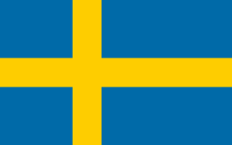
The 33rd America's Cup Race was won by Golden Gate Yacht Club racing team BMW Oracle, founded by Larry Ellison. A possible use of the air station that was considered was to partner with San Francisco for 34th America's Cup. Within 2 weeks of the Golden Gate Yacht Club winning the America's Cup, Alameda city council with local support sent a unanimous letter of support to hold AC 34 in San Francisco Bay Area. In early 2011, the City Council created an ad hoc America's Cup Citizens Advisory Committee to look for ways that Alameda could draw interest from teams and potential spectators. Through these efforts, the Swedish Artemis Racing team created their team base in one of the former air station hangars on Alameda Point, with a dock at Seaplane Lagoon.
Beer, wine and spirits production
A cluster of artisan distilleries, wineries, breweries and tasting rooms along Monarch Street at Alameda Point is now referred to by the City of Alameda as "Spirits Alley".[42] These business include Rock Wall Winery, Building 43 Winery,[43]Hangar 1, St. George Spirits and Faction Brewing.[44] In 2017, Admiral Maltings opened at Alameda Point.[45] Designed to supply craft brewers and whisky producers, it is the first craft malting house in California.[45]
The modern era of winemaking in Alameda begin in 1978 when Alameda veterinarian Kent Rosenblum and his wife Kathy founded Rosenblum Cellars. In 2008, the company was purchased by Diageo Estates for $105 million.[46] In 2014, the Rosenblum tasting room at Alameda Point closed and moved to Jack London Square in Oakland.[47] Shauna Rosenblum, daughter of Kent and Kathy, is the wine maker for Rock Wall Winery. In December, 2007, St. George Absinthe Verte, produced by St. George Spirits became the first brand of American-made absinthe to be legally produced in the United States since a ban was enacted in 1912.
Alameda Island Brewing is located on Park Street.
Movie theaters
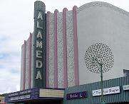
The city restored the historic Art Deco city landmark Alameda Theatre, expanding it to include a theater multiplex. The public opening was May 21, 2008.
The South Shore Mall Twin Cinema opened in 1969 and served as a prominent theater on the island until its closure in 1998. In 2002, the building was demolished and its former site is now a parking lot.
A small theater named Central Cinema opened in 2004, located in the building of a former mortuary.[48] Filled with couches and armchairs instead of traditional theater seating, the 40 seat venue was often compared to Oakland's Parkway Theater. The theater operated until June 2008 when the owner closed the cinema, citing he could not compete with the new Alameda multiplex.[49]
Top employers
According to the City's 2016 Comprehensive Annual Financial Report,[50] the top employers in the city are:
| # | Employer | # of Employees |
|---|---|---|
| 1 | Alameda Unified School District | 876 |
| 2 | Penumbra Inc | 858 |
| 3 | VF Outdoor | 751 |
| 4 | Alameda Hospital | 694 |
| 5 | Oakland Raiders | 604 |
| 6 | City of Alameda | 518 |
| 7 | Abbott Diabetes Care Inc | 512 |
| 8 | Safeway | 480 |
| 9 | Wind River Systems | 447 |
| 10 | Kaiser Foundation Health Plan | 425 |
Local newspapers and magazines
Alameda's first newspaper, the Encinal, appeared in the early 1850s and the paper's editor was instrumental in the movement to incorporate the city. Following the Encinal, several other papers appeared along geographic lines, and the Daily Argus eventually rose to prominence. A young Alameda native, Joseph R. Knowland, wrote political and historical articles for the Alameda papers. Later, Knowland owned the powerful Oakland Tribune. Around 1900, the Daily Argus began to fade in importance and east and west papers The Times and The Star combined to take the leading role as the Alameda Times-Star in the 1930s. The Times-Star was sold to the Alameda Newspaper Group in the 1970s.
In 1997, the Hills Newspaper chain was bought by Knight Ridder, at the time, the second-largest newspaper chain in the U.S. Following the buyout, former Hills Newspapers employees recognized the lack of a local community voice in Alameda, and again formed a new locally based newspaper, the Alameda Sun, in 2001. In 2006, Knight Ridder announced its impending sale to McClatchy Corp., a Sacramento-based publishing firm. McClatchy Corp. has put the Contra Costa Times, which under the Knight Ridder reorganization included all five of the original Hills Newspapers, up for sale. The current owners of the Alameda Times-Star, Digital First Media, based in Colorado, have announced a strong interest in buying both the Contra Costa Times chain and the San Jose Mercury News, consolidating the daily newspaper market of the East Bay, effectively under one owner. MediaNews closed the Times-Star in 2011.
The Alameda community is currently served by two weekly newspapers, the Alameda Journal, owned by the Digital First Media, and the Alameda Sun.
Services
Alameda Free Library
After two previous failures, voters in the city passed a ballot measure in 2000 authorizing a bond measure for construction of a new main library to replace the city's Carnegie library, damaged during the 1989 Loma Prieta earthquake. The city also received state funds for the new main library and opened the doors to the new facility in November 2006.
There are three library locations: the Main Library in downtown Alameda and two library branches; the Bay Farm Island Library serving the Bay Farm and Harbor Bay communities and the West End Library serving the West End of Alameda.
Alameda Hospital
Founded in 1894, Alameda Hospital is located at Clinton Avenue and Willow Street.
Alameda Municipal Power
Unlike surrounding communities, Alameda has a municipal power service, Alameda Municipal Power (AMP), that delivers services directly to consumers. AMP sold the majority of its telecommunications business to Comcast in 2008 but continues to provide telecommunication service at Alameda Point.
During the California electricity crisis of 2000 and 2001, Alameda Municipal Power did not raise electricity rates, while residents in most of the state endured significant price increases.[51]
Arts and culture
The Alameda Arts Council (AAC) serves as the local Alameda City arts council. The Alameda Civic Ballet is the ballet troupe of the city. The Alameda Museum features displays on the history of Alameda.[52] The Alameda Art Association has about 80 members as of January 2011, and has a gallery space at South Shore Center mall. The Association began in 1944. An annual benefit, Circus for Arts in the Schools, was started by clown artist Jeff Raz in 2004. Photo-realist Robert Bechtle has painted numerous Alameda subjects, including "Alameda Gran Torino", which was acquired by SFMOMA in 1974 and remains one of Bechtle's most famous works.[53]
Films shot in Alameda
Alameda has been home to many movie sets. Some of the movies filmed on the island have included Bicentennial Man, The Net, The Matrix Reloaded, The Matrix Revolutions, Bee Season, the original 1968 Your, Mine and Ours and the movie musical Rent. Parts of Alameda High School were animated for the Animatrix episode "Kid's Story". A massive hangar at the former Naval Air Station Alameda was used to film special scenes requiring computer-generated imagery for movies such as Bicentennial Man, Flubber, What Dreams May Come, Mission: Impossible 2 and many scenes from the Matrix trilogy, including the signature bullet time scene. The open space of the decommissioned naval base often hosts MythBusters' more dangerous experiments. The movie "Spirit Of '76" was filmed all throughout Alameda.
The documentary, Shallow Waters: The Public Death of Raymond Zack was filmed at Alameda locations, and chronicled the 2011 Death of Raymond Zack on Crown Beach in Alameda. The film was screened in 2016 at the Michaan Auction House Theater in Alameda.
The USS Hornet Museum, permanently moored at Alameda Point, has been the site for scenes used in major theatrical releases: XXX: State of the Union, Rescue Dawn, and The Master. In addition, the aircraft carrier has been used for television shows such as JAG, Carrier, Looking, The Great Escape, and the special military episode of Fear Factor; plus a number of television commercials.[54]
The Altarena Playhouse
The Altarena Playhouse, which performs comedies, dramas and musicals, was founded in 1938 and is the longest continuously operating community theater in the San Francisco Bay Area.
Rhythmix Cultural Works
Rhythmix Cultural Works (RCW) brings people of all ages together to experience and explore music, dance, visual art and educational opportunities. RCW's programs are housed in a restored industrial waterfront building that speaks to Alameda’s history while creating an inclusive venue that reflects the Bay Area’s rich diversity. The organization offers an array of arts programming to the community including Island Arts, Island City Waterways, Round the World Festival and its Performance Art and Learning program (PAL) that serves more than 2000 youth with free cultural arts assemblies each year.
Festivals on Webster Street
Webster Street in Alameda has long been the host of many arts, crafts and holiday festivals. During some of these festivals, the Chamber of Commerce along with the West Alameda Business Association (WABA) will block of a portion of Webster St. for the entertainment of festival goers. Festivals such as The Island JAM formerly known as the Peanut Butter Jam Festival brings a lot of local and outside visitors. Other event on the "West-End" include Trick-or-Treat on Webster Street where merchants supply goodies for local children and culminates with a parade and costume contest; in December "Santa Claus Meet-n-Greet on Webster Street" happens with elves, and a photo with the big guy.
Festivals on Park Street
There are three major events when the street in Alameda's historic downtown district is closed to vehicular traffic. The Park Street Spring Festival takes place every May during the weekend of Mother's Day and attracts over 50,000 visitors. The Park Street Art & Wine Faire takes place the last weekend of every July and attracts over 100,000 visitors. Both street fairs feature over 150 arts & crafts vendors, food vendors, beer and wine pouring, a children's area, and two stages with regional entertainment. The Park Street Classic Car Show is held on the second Saturday every October and displays over 400 vintage vehicles.[55]
Notable people
- Albert Arents, mining engineer who helped develop mineral resources of Rocky Mountains.
- Ian Axel, originally from Fair Lawn, New Jersey; singer-songwriter, lead singer of two-member indie group A Great Big World.
- John Baker, MLB catcher for San Diego Padres and Chicago Cubs, was born in Alameda.
- Shirley Temple Black, actress and former U.S. ambassador, resident.
- Mike Brisiel, offensive guard for Oakland Raiders.
- Virginia Lee Burton, Caldecott-winning children's author and illustrator.
- Harold Camping, television and radio personality, president and general manager of Family Stations, Inc.
- One of Alameda's most famous natives was General James Doolittle, who won the Medal of Honor for his bombing of Japan during World War II; Doolittle was born in Alameda in 1896.
- Garrett Eckbo, landscape architect who lived in Alameda as a child, later forming the Bay Area firm of Eckbo, Royston, Williams with Robert Royston and Edward Williams.
- Actor Leif Erickson was born in Alameda in 1911.
- College basketball coach Larry Eustachy was born in Alameda.
- Debbi Fields, founder of Mrs. Fields Cookies, attended Alameda High School, where she was a cheerleader.
- Albert Ghiorso, nuclear scientist, co-discoverer of 12 chemical elements on periodic table; in Guinness Book of World Records for Most Elements Discovered.
- Brad Gillis, guitarist with Night Ranger, a San Francisco rock band formed in the 1980s.
- Katharine Graham, the late publisher of the Washington Post, lived in Alameda as a child, according to Personal History, her autobiography.
- Tim Hardaway Jr., professional basketball player, was born in Alameda.
- Bandleader and radio personality Horace Heidt was born in Alameda on May 21, 1901.
- Bruce Henderson, author, lived in Alameda, according to his book Hero Found: The Greatest POW Escape of the Vietnam War.
- Benjamin Jealous, former President of the NAACP, lived in Alameda.
- Mikael Johnston, founding member of Warner Bros. Records house music act Mephisto Odyssey.
- Alameda native congressman Joseph R. Knowland was editor and publisher of the Oakland Tribune.
- The late U.S. Senator William Fife Knowland was student body president at Alameda High School.
- Robert L. Lippert, theater chain owner and film producer, was an Alameda native.
- Paul Mantz, air racer and Hollywood stunt pilot, was born in Alameda in 1903.
- Louis A. McCall, Sr., drummer and musician best known as co-founder of Con Funk Shun.
- Margaret McNamara, founder of Reading is Fundamental, and wife of Robert McNamara, grew up in Alameda.
- George P. Miller, congressman from 1945 to 1973.
- Hugo Wilhelm Arthur Nahl, designer of Seal of California.
- Don Perata, former President Pro Tempore of California State Senate, lives in Alameda; once taught at Saint Joseph Notre Dame High, Encinal High and Alameda High, among other Alameda schools.
- Carl Ravazza, bandleader, born in Alameda, 1910.
- Bill Rigney, Major League Baseball player and manager, was born in Alameda.
- Dutch Ruether, pitcher for 1927 New York Yankees, was born in Alameda.
- Operatic mezzo-soprano Frederica Von Stade still gives performances and supports the arts in local schools, but no longer lives in Alameda.
- Alameda was briefly the home of author Robert Louis Stevenson.
- Sharon Tate, actress, resident in early to late-1960s.[56]
- Charles Lee Tilden, for whom Tilden Regional Park is named, was a longtime resident of Alameda; Tilden Way at the southeast end of the city is named for him.
- Baseball Hall of Famer Willie Stargell, MLB player Tommy Harper, MLB player Curtell Howard Motton, 2003 National League Rookie of the Year Dontrelle Willis, 2007 National League Most Valuable Player Jimmy Rollins, NBA player J.R. Rider, and NFL players Melvin Carver[57] and Junior Tautalatasi[58][59] all attended Encinal High School.
- NBA player and coach Jason Kidd and MLB pitcher Joe Nelson attended St. Joseph Notre Dame High School in Alameda.
- MLB players Ray French, Johnny Vergez, Andy Carey, Bill Serena, Erik Schullstrom, Dick Bartell, Duffy Lewis and Chris Speier all attended Alameda High School.
- Many people from naval families, including celebrities such as Ann Curry, Phyllis Diller, Tom Hanks, and Jim Morrison of The Doors,[60] have lived in Alameda.
Education
Public primary and secondary education in Alameda is the responsibility of the Alameda Unified School District, which is legally separate from the City of Alameda government (as is common throughout California). The College of Alameda, a two-year community college in the West End is part of the Peralta Community College District. The city has numerous private primary schools, and one private high school, St. Joseph Notre Dame High School, a Catholic school.
Sister cities
Alameda's relationships with Wuxi and Jiangyin were initiated in 2005, in part, by Stewart Chen, who then served on the City of Alameda Social Service and Human Relations board, and who went on to be elected to Alameda City Council in November, 2012.[61]
Wuxi, China, is a so-called friendship city, because the diplomacy organization Sister Cities International does not recognize the relationship.[62]


Friendship city
Controversy
In September, 2013, a Tibetan rights group initiated a social media and e-mail campaign [63] targeting the Mayor of Alameda, complaining that City of Alameda's participation in, and association with, a flag-raising ceremony to recognize National Day of the People's Republic of China on October 1 was tantamount to endorsing the communist regime in China, its human rights abuses, and the occupation of Tibet. The City of Alameda responded that the ceremony was a function of the Alameda Sister City Association and the Alameda Wuxi Friendship Committee, not a function of the City of Alameda. The Tibetan rights group responded that on September 26, the City of Alameda Social Service and Human Relations board appointed a member, Michael Robles-Wong, as a representative to the Sister City Association.[64]
On October 1, 2013, the Tibetan rights groupsTibetTruth and Bay Area Friends of Tibet sent roughly 75 protesters to Alameda City Hall to protest the ceremony, which organizers ultimately canceled before it began. Former City of Alameda Councilmember Frank Matarrese announced the cancellation.[65] Then-city councilmember Stewart Chen subsequently defended the ceremony, as a diplomatic, not political, exercise.[66]
See also
- Earl King, Ernest Ramsay, and Frank Conner, convicted of murdering a ship's officer in Alameda, 1936
- List of islands of California
- List of ships built in Alameda, California
References
- ↑ "The Island City". Archived from the original on July 26, 2011. Retrieved July 13, 2017.
- ↑ Baker, Joseph Eugene (1914). Past and present of Alameda County, California, Volume 1. S.J. Clarke. p. 327.
- ↑ "Trish Herrera Spencer". City of Alameda. Retrieved January 9, 2015.
- ↑ "Senators". State of California. Retrieved March 18, 2013.
- ↑ "Members Assembly". State of California. Retrieved March 18, 2013.
- ↑ "California's 13th Congressional District - Representatives & District Map". Civic Impulse, LLC. Retrieved March 12, 2013.
- ↑ "2017 U.S. Gazetteer Files". United States Census Bureau. Retrieved Aug 27, 2018.
- ↑ "Alameda". Geographic Names Information System. United States Geological Survey.
- 1 2 "Population and Housing Unit Estimates". Retrieved March 24, 2018.
- ↑ "ZIP Code(tm) Lookup". United States Postal Service. Retrieved November 24, 2014.
- ↑ "New State Population Report" (PDF). California Department of Finance. May 1, 2017. Retrieved June 20, 2017.
- ↑ Gannett, Henry (1905). The Origin of Certain Place Names in the United States. Govt. Print. Off. p. 119.
- ↑ "alameda – Spanish-English Translation and Pronunciation". Yahoo! Education. Yahoo!. Archived from the original on August 21, 2008. Retrieved February 15, 2010.
- ↑ "A Brief History of Alameda". A Brief History of Alameda. City of Alameda, California. Archived from the original on February 2, 2010. Retrieved February 15, 2010.
- 1 2 3 4 5 6 7 Durham, David L. (1998). California's Geographic Names: A Gazetteer of Historic and Modern Names of the State. Clovis, Calif.: Word Dancer Press. p. 592. ISBN 1-884995-14-4.
- ↑ Twain, Mark. Autobiography of Mark Twain, Volume 1: The Complete and Authoritative Edition. University of California Press. p. 254. ISBN 978-0-520-94699-6.
- ↑ "Around Town – Alameda, CA". Archived from the original on December 5, 2008. Retrieved December 6, 2007.
- ↑ "Alameda Museum Quarterly Newsletter" (PDF). p. 8. Archived from the original (PDF) on February 29, 2008. Retrieved December 4, 2007.
- ↑ paula. "Alameda all at once - 48 hills". 48 hills. Retrieved 2017-06-12.
- ↑ "11 Goners - Alameda Magazine - December 2011 - Alameda, California". www.alamedamagazine.com. Retrieved 2017-06-12.
- ↑ Rego, Nilda (December 18, 2013). "Days Gone By: In 1902, 'island city' Alameda celebrates its new tidal canal". San Jose Mercury News.
- ↑ Bender, Kristin (March 22, 2006). "After 80 years, Alameda named 'Coast Guard City'". Oakland Tribune. BNET. Archived from the original on February 2, 2010. Retrieved February 15, 2010.
- ↑ Freeman, Paul (December 27, 2009). "Abandoned & Little-Known Airfields: Oakland Area". Abandoned & Little-Known Airfields: California. Paul Freeman. Retrieved February 15, 2010.
- ↑ "The Crash of Navy A-7E Corsair II – Alameda, Calif. – February 7, 1973". Check-Six.com. Retrieved 11 September 2014.
- ↑ Kulczyk, David. (2009). Death In California – The Bizarre, Freakish, and Just Curious Ways People Die in the Golden State. Craven Street Books. P117 ISBN 978-1-884995-57-6
- ↑ "Historic California Posts: Naval Air Station, Alameda". www.militarymuseum.org. Retrieved July 13, 2017.
- ↑ "ISC Alameda Home". webarchive.loc.gov. Archived from the original on November 9, 2001. Retrieved July 13, 2017.
- ↑ "Alameda, California Köppen Climate Classification (Weatherbase)". Weatherbase. Retrieved July 13, 2017.
- ↑ "Census of Population and Housing". Census.gov. Archived from the original on May 12, 2015. Retrieved June 4, 2015.
- ↑ "2010 Census Interactive Population Search: CA – Alameda city". U.S. Census Bureau. Retrieved July 12, 2014.
- ↑ US Census
- ↑ "Demographic Profile Bay Area Census".
- ↑ "American FactFinder". United States Census Bureau. Archived from the original on September 11, 2013. Retrieved 2008-01-31.
- ↑ "Alameda". www.californiajapantowns.org. Retrieved July 13, 2017.
- ↑ "Maintenance and Operations Department". Alameda County Public Works Agency. Archived from the original on February 9, 2010. Retrieved February 15, 2010.
- ↑ Maintenance and Operations Department Alameda County Government website
- ↑ "BART gets serious about a 2nd East Bay-S.F. Transbay Tube". San Francisco Chronicle. Retrieved 2018-03-06.
- ↑ "Best Of The East Bay 2017". East Bay Express. Retrieved July 13, 2017.
- 1 2 3 Rubin, Sylvia. (January 7, 1988) San Francisco Chronicle Neighbor against neighbor; Mediators can resolve disputes. Section: People, Page B3.
- ↑ "Media - City of Alameda 4th of July Parade". alamedaparade.com. Retrieved July 13, 2017.
- ↑ "Alameda Point Timeline - Alameda Point Info". alamedapointinfo.com. Retrieved July 13, 2017.
- ↑ https://alamedaca.gov/visitors/spirits-alley
- ↑ http://www.building43winery.com/
- ↑ "FACTION BREWING –". factionbrewing.com. Retrieved 2018-03-06.
- 1 2 https://www.sfchronicle.com/restaurants/article/Admiral-Maltings-germinates-California-alt-malt-11273732.php
- ↑ "Beverage Giant Diageo Buys Rosenblum for $105 Million | News | News & Features | Wine Spectator". WineSpectator.com. Retrieved 2018-03-06.
- ↑ Ellson, Michele (2014-04-15). "Rosenblum tasting room leaving Alameda". The Alamedan. Retrieved 2018-03-06.
- ↑ "Alameda frets over cozy cinema". San Francisco Chronicle. 2005-02-11. Retrieved 2018-03-23.
- ↑ "Alameda Theater, the Sequel". East Bay Express. 2008-05-21. Retrieved 2018-03-23. Mark Haskett of tiny Central Cinema... says he will have to close his current location on June 30 due to distribution troubles brought on by the new theaters.
- ↑ "City of Alameda CAFR" (PDF). Retrieved July 13, 2017.
- ↑ Alameda Produces Its Own Energy Island residents sustain low rates GeorgeRaine / SF Chronicle 13jan01 Archived March 25, 2005, at the Wayback Machine. Alameda Produces Its Own Energy Island residents sustain low rates SF Chronicle, Jan 13, 2001 (archived)
- ↑ Northern California. Heathrow, Florida: AAA Publishing. 2012. p. 43.
- ↑ "Robert Bechtle, Alameda Gran Torino, 1974". SFMOMA. Retrieved July 13, 2017.
- ↑ http://www.uss-hornet.org/groups/filming/ USS Hornet Museum website, film and television location rentals
- ↑ http://www.shopparkstreet.com/ Park Street Business Association website, special events
- ↑ https://www.imdb.com/name/nm0001790/
- ↑ "Mel Carver Stats | Pro-Football-Reference.com". Pro-Football-Reference.com. Retrieved 2017-10-05.
- ↑ "Hall of Famers". Alameda Sports Project. Retrieved 9 August 2016.
- ↑ McGreehan, Mike. "Spotlight on Encinal's Hall of Fame athletes". East Buy Times. Retrieved 9 August 2016.
- ↑ The Lizard King Next Door | Gawker Archived September 23, 2013, at the Wayback Machine.
- ↑ "Students from Chinese sister city tour Alameda". The Alamedan. Retrieved October 3, 2013.
- ↑ "Alameda Forges Ties With Jiangyin, China". Alameda Sun. Archived from the original on September 29, 2013. Retrieved October 1, 2013.
- ↑ tibettruth (September 25, 2013). "Asking The Mayor Of Alameda Not To Fly China's Flag". Retrieved July 13, 2017.
- ↑ "Tibetan Rights Group Takes City to Task on Twitter, by Email". Action Alameda News. Retrieved October 1, 2013.
- ↑ "Protesters force cancellation of China's National Day celebration". Mercury News. Retrieved October 3, 2013.
- ↑ "Chinese Culture Does Deserve Celebration" (PDF). Alameda Sun. Retrieved October 20, 2013.
External links
| Wikimedia Commons has media related to Alameda, California. |
| Wikivoyage has a travel guide for Alameda. |
- Official website


| Landmarks | |
|---|---|
| Economy | |
| Education | |
| History | |
| Infrastructure | |
| Other | |
| |
Municipalities and communities of Alameda County, California, United States | ||
|---|---|---|
| Cities | 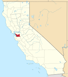 | |
| CDPs | ||
| Unincorporated communities | ||
| Former settlements | ||
| Bodies of water |
|  |
|---|---|---|
| Counties | ||
| Major cities | ||
| Cities and towns 100k–250k | ||
| Cities and towns 50k–99k | ||
| Cities and towns 25k-50k | ||
| Cities and towns 10k–25k |
| |
| Sub-regions | ||
