Downey, California
| Downey, California | |||
|---|---|---|---|
| City | |||
| City of Downey | |||
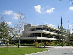 The Downey City Hall in 2006 | |||
| |||
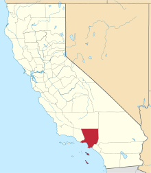
 Location of Downey in Los Angeles County, California. | |||
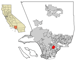
 Downey, California Location in the United States | |||
| Coordinates: 33°56′17″N 118°07′51″W / 33.93806°N 118.13083°WCoordinates: 33°56′17″N 118°07′51″W / 33.93806°N 118.13083°W | |||
| Country |
| ||
| State |
| ||
| County |
| ||
| Founded | October 23, 1873 | ||
| Incorporated | December 17, 1956[1] | ||
| Named for | Gov. John G. Downey | ||
| Government | |||
| • Type | Council-manager | ||
| • City Council[2] |
Mayor Sean Ashton Blanca Pacheco Rick Rodriguez (Mayor Pro Tem) Fernando Vasquez Alex Saab | ||
| • City manager | Gilbert A. Livas[3] | ||
| Area[4] | |||
| • Total | 12.57 sq mi (32.55 km2) | ||
| • Land | 12.41 sq mi (32.14 km2) | ||
| • Water | 0.16 sq mi (0.41 km2) 1.27% | ||
| Elevation[5] | 118 ft (36 m) | ||
| Population (2010)[6] | |||
| • Total | 111,772 | ||
| • Estimate (2016)[7] | 113,267 | ||
| • Rank |
11th in Los Angeles County 53rd in California | ||
| • Density | 9,128.55/sq mi (3,524.53/km2) | ||
| Time zone | UTC-8 (PST) | ||
| • Summer (DST) | UTC-7 (PDT) | ||
| ZIP codes | 90239-90242 | ||
| Area code | 562 | ||
| FIPS code | 06-19766 | ||
| GNIS feature IDs | 1652698, 2410352 | ||
| Primary Airport |
Los Angeles International Airport LAX (Major/International) | ||
| Secondary Airport |
Hollywood Burbank Airport- BUR (Regional) Van Nuys Airport- VNY (Regional) Long Beach Airport- LGB (Regional) | ||
| Interstates |
| ||
| State Routes |
| ||
| Rapid Transit |
| ||
| Website |
www | ||
Downey is a city located in southeast Los Angeles County, California, United States, 13 mi (21 km) southeast of downtown Los Angeles. It is considered part of the Gateway Cities. The city is the birthplace of the Apollo space program, and is the hometown of Richard and Karen Carpenter. It is also the home of the oldest still operational McDonald's restaurant in the world. As of the 2010 census, the city had a total population of 111,779.
History
Before the Spanish Empire
Prior to the arrival of the Spanish in Alta California, the area that is now Downey was inhabited by the Tongva ethnic group, which came to be called the Gabrielino by the Spanish. The nearest Tongva settlements appear to have been just north and northeast of present-day Downey, although there is difficulty in locating them precisely.[8] The villages of Naxaaw’nga and Sehat seem to have been situated near the present-day community of Los Nietos, or perhaps farther west on sites that were lost to floods of the San Gabriel River. Chokiishnga and Huutnga are other Tongva place names that may have referred to villages in the general area north of Downey between the San Gabriel River and Rio Hondo.[9] In all four cases, it is difficult to relate the original location descriptions, based on ranchos and land grants, to more specific sites identifiable by today's landmarks.
18th century until World War II
Mission San Gabriel Arcángel was initially founded on September 8, 1771, near these concentrations of Tongva population, at a site in the Whittier Narrows on a bluff overlooking the Rio Hondo near the intersection of today's San Gabriel Blvd and Lincoln Avenue.[10] After five years, flooding forced the relocation of the mission to its present site in San Gabriel.
In 1784, Governor Pedro Fages granted to former soldier Manuel Nieto (1734–1804) the largest of the land concessions made during the Spanish control of California. Its 300,000 acres (120,000 ha; 1,200 km2) stretched from the Santa Ana River on the east to the Old San Gabriel River (now the Rio Hondo and Los Angeles River) on the west, and from the mission highway (approximately Whittier Boulevard) on the north to the ocean on the south. Its acreage was slightly reduced later at the insistence of Mission San Gabriel on whose lands it infringed. The Spanish concessions, of which 25 were made in California, were unlike the later Mexican land grants in that title was not transferred, but were similar to grazing permits, with the title remaining with the Spanish crown.[11]
The Rancho Los Nietos passed to Manuel Nieto's four children upon his death and remained intact until, in 1833, his heirs petitioned Mexican Governor José Figueroa to partition the property. The northwestern portion of the original rancho, comprising the Downey-Norwalk area, was granted as Rancho Santa Gertrudes to Josefa Cota, the widow of Manuel's son, Antonio Nieto. At approximately 21,000 acres (8,500 ha; 85 km2), Santa Gertrudes was itself a sizable rancho and contained the old Nietos homestead, which was a center of social life east of the pueblo of Los Angeles.[12] After the Mexican–American War concluded in 1848, many of the Californio ranchos were obtained by affluent Anglo-Americans who were immigrating west under the United States manifest destiny doctrine, and marrying into established Californio Spanish families. This migration was distinct from that prompted by the California Gold Rush farther north.
Dairy was a major industry in Downey. The Central Milk Agency marketed the milk for "seven hundred dairymen whose dairy herds range from thirty to two thousand head" with the value of the products marketed in excess of $1,000,000 per month.[13]
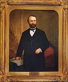
Some of Downey's settlers came from Ireland.[14] Downey was founded by and named for the former and youngest ever governor of California, John Gately Downey, who was born in Ireland. Although he was an Irish Democrat, he supported the Republican Lincoln in his efforts to keep the Union intact during the American Civil War. He pioneered the modern subdivision with land he acquired between the Rio Hondo and the San Gabriel River, in about 1865. Downey was convinced that oranges would flourish in Southern California, so he imported several varieties, and therefore set in motion what became one of the state's biggest cash crops.[14] In conjunction with the construction of the Tehachapi Loop, the Southern Pacific Railroad arrived in 1873.
After World War II
Farmers in the area grew grain, corn, castor beans and fruit, and by 1935 Downey was characterized as an "orange-grove town".[16] Downey was incorporated in 1956, and instituted a charter form of government in 1964. Suburban homes and factories replaced the farms after World War II.
Aerospace
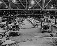
Vultee Aircraft was Downey's largest employer during World War II, producing 15% of all of America's military aircraft by 1941.[17] The company was a pioneer in the use of women in manufacturing positions, and was the first aircraft company to build airplanes on a powered assembly line.[15] Vultee became a part of North American Aviation, (later North American Rockwell, then Rockwell International which was then bought by the Boeing company) whose facilities were the birthplace of the systems for the Apollo Space Program as well as the Space Shuttle. For over 70 years, Downey's Rockwell NASA plant produced and tested many of the 20th century's greatest aviation, missile, and space endeavors. By the early 1970s, the facilities encompassed some 1,700,000 square feet (160,000 m2) of enclosed area over more than 200 acres (81 ha). But, by the post-Cold War 1990s, Downey was brutally hit by cutbacks in the defense budget. Rockwell International, who once had over 30,000 employees, had less than 5,000 in 1992. The seventy-year history of airplane and space vehicle manufacturing in Downey came to an end when the Rockwell plant closed in 1999. The former North American Rockwell plant was demolished, and the site now features the Columbia Memorial Space Center,[18] Downey Landing shopping center, a Kaiser Permanente hospital, a city recreation fields park, and the former movie studio site of Downey Studios.
Other landmarks
Near the center of the city lies what was the 1960s the busiest intersections in California, the intersection of Lakewood Boulevard (State Route 19) and Firestone Boulevard (former State Route 42). Route 19 was a major thoroughfare between Pasadena and the port at Long Beach, and Route 42 was along part of the old Spanish El Camino Real trail that connected Pueblo de Los Angeles to San Diego.
In the 1960s the town's Downey Records achieved some notoriety with recordings such as The Chantays' surfing instrumental "Pipeline"; nearly two decades later, Downey local music scene led to the founding of The Blasters and Dark Angel.
Downey is home to Rancho Los Amigos National Rehabilitation Center, which is the main public rehabilitation hospital for Los Angeles County. Rancho Los Amigos is renowned worldwide for its innovative contributions to the care of spinal cord injuries and post-polio syndrome.[19]
Downey was featured in the 2008 American action comedy film Pineapple Express. Many of the buildings along Florence Avenue are seen in a driving sequence early in the film.[20]
Geography
According to the United States Census Bureau, the city has a total area of 12.6 square miles (33 km2). 12.4 square miles (32 km2) of it is land and 0.2 square miles (0.52 km2) of it (1.27%) is water.
The cities of South Gate and Bell Gardens are adjacent to the west and northwest, Pico Rivera lies to the northeast, Santa Fe Springs and Norwalk to the east, and Paramount and Bellflower are to the south.
Climate
According to the Köppen Climate Classification system, Downey has a semi-arid climate, abbreviated "BSk" on climate maps.[21]
Demographics
| Historical population | |||
|---|---|---|---|
| Census | Pop. | %± | |
| 1960 | 82,505 | — | |
| 1970 | 88,573 | 7.4% | |
| 1980 | 82,602 | −6.7% | |
| 1990 | 91,444 | 10.7% | |
| 2000 | 107,323 | 17.4% | |
| 2010 | 111,772 | 4.1% | |
| Est. 2016 | 113,267 | [7] | 1.3% |
| U.S. Decennial Census[22] | |||
2010
The 2010 United States Census[23] reported that Downey had a population of 111,772. The population density was 8893.3 people per square mile (3,433.7/km²). The racial makeup of Downey was 63,255 (56.6%) White (17.7% Non-Hispanic White),[24] 7,804 (7.0%) Asian (2.2% Korean, 2.2% Filipino, 0.6% Indian, 0.5% Chinese, 0.3% Vietnamese, 0.3% Japanese, 0.2% Thai, 0.1% Cambodian, 0.1% Pakistani), 4,329 (3.9%) African American, 820 (0.7%) Native American, 221 (0.2%) Pacific Islander, 30,797 (27.6%) from other races, and 4,546 (4.1%) from two or more races. Hispanic or Latino of any race were 78,996 persons (70.7%); 54.0% of Downey residents are of Mexican ancestry, 3.9% Salvadoran, 2.0% Cuban, 2.0% Guatemalan, 1.1% Peruvian, and 1.0% Nicaraguan ancestry.
The Census reported that 111,089 people (99.4% of the population) lived in households, 122 (0.1%) lived in non-institutionalized group quarters, and 561 (0.5%) were institutionalized.
There were 33,936 households, out of which 15,697 (46.3%) had children under the age of 18 living in them, 17,405 (51.3%) were opposite-sex married couples living together, 6,289 (18.5%) had a female householder with no husband present, 2,796 (8.2%) had a male householder with no wife present. There were 2,357 (6.9%) POSSLQ, and 225 (0.7%) same-sex married couples or partnerships. 5,721 households (16.9%) were made up of individuals and 2,211 (6.5%) had someone living alone who was 65 years of age or older. The average household size was 3.27. There were 26,490 families (78.1% of all households); the average family size was 3.68.
The population was spread out with 29,972 people (26.8%) under the age of 18, 12,108 people (10.8%) aged 18 to 24, 33,056 people (29.6%) aged 25 to 44, 25,057 people (22.4%) aged 45 to 64, and 11,579 people (10.4%) who were 65 years of age or older. The median age was 33.3 years. For every 100 females, there were 94.1 males. For every 100 females age 18 and over, there were 90.4 males.
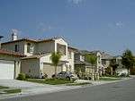
There were 35,601 housing units at an average density of 2,832.7 per square mile (1,093.7/km²), of which 17,135 (50.5%) were owner-occupied, and 16,801 (49.5%) were occupied by renters. The homeowner vacancy rate was 1.4%; the rental vacancy rate was 4.9%. 59,555 people (53.3% of the population) lived in owner-occupied housing units and 51,534 people (46.1%) lived in rental housing units. Approximately 30–40 homeless reside in the area.[25]
According to the 2010 United States Census, Downey had a median household income of $60,939, with 11.8% of the population living below the federal poverty line.[24]
2000
As of the 2000 United States Census,[26] there were 107,323 people, 33,989 households, and 26,001 families residing in the city. The population density was 8,641.7 inhabitants per square mile (3,336.4/km2). There were 34,759 housing units at an average density of 2,798.8 per square mile (1,080.6/km2). The racial makeup of the city was 53.48% White, 7.74% Asian, 3.75% Black or African American, 0.87% Native American, 0.22% Pacific Islander, 29.05% from other races, and 4.89% from two or more races. 57.85% of the population were Hispanic or Latino of any race.
There were 33,989 households out of which 41.8% had children under the age of 18 living with them, 54.1% were married couples living together, 15.8% had a female householder with no husband present, and 23.5% were non-families. 19.1% of all households were made up of individuals and 8.1% had someone living alone who was 65 years of age or older. The average household size was 3.11 and the average family size was 3.55.
In the city, the population was spread out with 29.2% under the age of 18, 9.8% from 18 to 24, 31.2% from 25 to 44, 18.8% from 45 to 64, and 11.0% who were 65 years of age or older. The median age was 32 years. For every 100 females, there were 94.6 males. For every 100 females age 18 and over, there were 89.8 males.
The median income for a household in the city was $46,000 and the median income for a family was $50,017. Males had a median income of $35,991 versus $28,768 for females. The per capita income for the city was $18,197. About 9.3% of families and 11.1% of the population were below the poverty line, including 14.4% of those under age 18 and 7.6% of those age 65 or over.
Latinos in Downey
Starting in the late 1980s, Downey has become a renowned Latino majority community in Southern California, and the majority of residents moved in were middle or upper-middle class, and second and third generation Mexican-Americans. [27]
Downey has the second highest percentage of Cubans and Cuban Americans in the Western United States at 1.96% of the population.[28]
There is also a Puerto Rican community in Downey, about 2.5% of the city population as of 2016.
Crime
While reports of robberies, aggravated assaults and petty thefts in Downey dropped in 2008, auto thefts reached a 10-year high. In 2008, 1,231 vehicles were reported stolen in Downey. Other crimes recorded by the FBI Crime Index for the year 2008 include 252 robberies, 172 aggravated assaults, 24 rapes, 711 burglaries and 2,038 acts of larceny/thefts.[29]
Anti-gang activities
In the late 1980s and early 1990s, Downey saw an increase in gang activity. Today there is still gang activity going in the south area of Downey. In response, Downey formed GOOD (Gangs Out Of Downey), a community-based organization that helps encourage young people between the ages of 10-20 to stay away from gangs. GOOD is also responsible for organizing many community events and programs such as various sports, after school care, scholarship programs for at-risk students looking to attend college, and counseling for both young people and their parents. GOOD has kept a close partnership with the Downey Police Department.[30]
Economy
Most Business-Friendly Award
In 2017, the City of Downey was recognized as L.A. County's "Most Business-Friendly City" by the Los Angeles County Economic Development Corporation for cities with a population greater than 68,000.[31]
Largest employers
According to the City's 2011 Comprehensive Annual Financial Report,[32] the top employers in the city are:
| # | Employer | # of Employees |
|---|---|---|
| 1 | Kaiser Permanente | 4,500 |
| 2 | Stonewood Center | 2,100 |
| 3 | Downey Unified School District | 1,851 |
| 4 | Rancho Los Amigos National Rehabilitation Center | 1,410 |
| 5 | PIH Health Hospital - Downey | 955 |
| 6 | Coca-Cola Refreshments | 920 |
| 7 | Office of Education, County of Los Angeles | 900 |
| 8 | Lakewood Park Health Center | 325 |
| 9 | Xpedex | 250 |
| 10 | Porto's Bakery | 190 |
| 11 | All American Home Center (since closed) | 180 |
Government
In the California State Legislature, Downey is in the 32nd Senate District, represented by Democrat Vanessa Delgado, and in the 58th Assembly District, represented by Democrat Cristina Garcia.[33]
In the United States House of Representatives, Downey is in California's 40th congressional district, represented by Democrat Lucille Roybal-Allard.[34]
Education
Primary and secondary schools
Most of Downey is within the Downey Unified School District. Downey's two main public high schools are named for Governor John G. Downey and Governor and US Supreme Court Chief Justice Earl Warren.
Downey has three public high schools: Downey, Warren, and Columbus. Other public schools include:
- Stauffer Middle School (formerly West Middle School)
- Doty Middle School (formerly East Middle School)
- Griffiths Middle School (formerly North Middle School)
- Sussman Middle School (formerly South Middle School)
- Alameda Elementary School
- Carpenter Elementary School
- Gallatin Elementary School
- Gauldin Elementary School
- Imperial Elementary School
- Lewis Elementary School
- Old River Elementary School
- Price Elementary School
- Rio Hondo Elementary School
- Rio San Gabriel Elementary School
- Unsworth Elementary School
- Ward Elementary School
- Williams Elementary School
Small sections are within the Montebello Unified School District.[35]
Private schools include:
Public libraries
The Downey City Library serves the city. The first library in Downey was established in 1901 by a women's social club that was founded in 1898. The County of Los Angeles Public Library opened a branch in Downey in September 1915. The county branch moved several times; its final location was in the County Civic Center. In 1958 the Downey City Council voted to establish its own library and withdraw from the county system. The city library services were originally provided out of the back of a bookstore. The city library opened in the former cafeteria of the former Downey Elementary School, then being used as the city hall and police station, on July 1, 1958. A permanent library building was built on December 7, 1959. It had almost 16,000 square feet (1,500 m2) and it was built for $186,200, costing $11.97 per square foot. It was dedicated on December 17 and opened on December 18. In February 1984 an addition of almost 12,000 square feet (1,100 m2) was completed and dedicated.[38]
In addition the headquarters of the County of Los Angeles Public Library are located in Downey.[39]
Infrastructure
Health care
The Los Angeles County Department of Public Health operates the Whittier Health Center in Whittier, serving Downey.[40]
Post office
The United States Postal Service operates the Downey Post Office at 8111 Firestone Boulevard,[41] the North Downey Post Office at 10409 Lakewood Boulevard,[42] and the South Downey Post Office at 7911 Imperial Highway.[43]
Transportation
The city can be conveniently reached by any of four freeways: Interstate 105 with its Metro rail line passes through the southern part of the city, Interstate 5 passes through the northern part, Interstate 605 passes along the eastern side, and Interstate 710 passes just west of the city.
Los Angeles County Metropolitan Transportation Authority (Metro) provides bus services to the city, and is served by the Lakewood Boulevard station of the Green Line (Los Angeles Metro). The city also operates a local bus service called DowneyLINK.
Notable people
- Dave Alvin, musician, founder of Downey-based rockabilly band The Blasters with brother Phil
- Bob Bennett, contemporary Christian musician, singer-songwriter, recording artist, was born in Downey
- Paul Bigsby, father of the modern electric solid-body guitar, built in 1948, and creator of the Bigsby vibrato
- William Bonin, serial killer; was Downey resident during his crime spree
- The Carpenters (singer-musicians Karen and Richard) moved to Downey in 1963, originally to an apartment complex called the Shoji on 12020 Downey Ave, later moving to a house that still stands on Newville Avenue which can be seen on the cover of their album, Now & Then;[44] after the duo's success, they built two apartment buildings still located on 5th St.
- Miranda Cosgrove, actress and singer, star of iCarly
- Rosario DeSimone (1873-1946), Downey-based crime boss
- Walt Faulkner, Indy car driver, first rookie to win pole position at Indianapolis 500
- Ed Fiori, professional golfer
- Donavon Frankenreiter, surfer and musician
- Kevin Gross, former Major League Baseball pitcher for Los Angeles Dodgers and Anaheim Angels[45]
- Dan Henderson, mixed martial artist
- James Hetfield, Metallica frontman
- Leon Hooten, former baseball player for Oakland Athletics[46]
- Robert Illes, Emmy-winning TV writer and producer
- Allison Iraheta, musician, American Idol Season 8 contestant
- Evan Longoria, an All-Star third baseman for the Tampa Bay Rays and the San Francisco Giants, was born in Downey[47]
- Ira J. McDonald, Los Angeles City Council member, 1941–43, Downey civic leader
- Ron McGovney, original Metallica bassist, spent school years in Downey
- Bob Meusel, baseball star for New York Yankees who played with Babe Ruth and Lou Gehrig, lived and died in Downey
- Riki R. Nelson, oil painter
- Tom Nieto, professional baseball player[48]
- George Pajon, Jr., Grammy Award-winning recording and performing artist[49]
- Lena Park, South Korean singer
- Wayne Rainey, former American Grand Prix motorcycle racer, was born in Downey
- Kimmy Robertson, actress best known for her role as Lucy Moran in Twin Peaks
- Rich Rodriguez, Major League Baseball pitcher 1990-2003
- Paul Ruffner, pro basketball player
- Kenneth Shelley, figure skater, U.S. champion and Olympian, was born in Downey
- Dennis Sproul, NFL player[50]
- JoJo Starbuck, figure skater, U.S. champion and Olympian, grew up in Downey
- Aimee Teegarden, actress (Friday Night Lights) and fashion model
- Alanna Ubach, actress
- Joan Weston, queen of Roller Derby, grew up in Downey
- "Weird Al" Yankovic, musician and parody artist, was born in Downey
- Joslyn Davis, host of Clevver TV and YouTube personality, was raised in Downey.
International relations
Downey is sister cities with Guadalajara, Mexico; San Quintín, Baja California, Mexico; Ensenada, Mexico; Fresnillo, Mexico; and Alajuela, Costa Rica.[51]
References
- ↑ "California Cities by Incorporation Date". California Association of Local Agency Formation Commissions. Archived from the original (Word) on November 3, 2014. Retrieved August 25, 2014.
- ↑ "Mayor & City Council". City of Downey. Retrieved December 19, 2014.
- ↑ "City Manager". City of Downey. Retrieved December 30, 2014.
- ↑ "2016 U.S. Gazetteer Files". United States Census Bureau. Retrieved July 19, 2017.
- ↑ "Downey". Geographic Names Information System. United States Geological Survey. Retrieved October 12, 2014.
- ↑ "Downey (city) QuickFacts". United States Census Bureau. Retrieved April 16, 2015.
- 1 2 "Population and Housing Unit Estimates". Retrieved June 9, 2017.
- ↑ McCawley, William (1996). The First Angelinos: the Gabrielino Indians of Los Angeles. Banning, CA: Malki Museum Press/Ballena Press.
- ↑ Reid, Hugo (1852). "Los Angeles County Indians." Los Angeles County Star, 1(41)–2(11) (February 24-July 24, 1852).
- ↑ Kyle, Douglas E. (1990). Historic Spots in California, 4th ed. Stanford, CA: Stanford University Press.
- ↑ Beck, Warren A., Haase, Ynez D. (1974). Historical Atlas of California. Norman: University of Oklahoma Press.
- ↑ Quinn, Charles Russell (1973). The History of Downey, California Published by Elena Quinn; copyright by City of Downey, California.
- ↑ Morrison, Easter Bangle (1939). History of Downey and Vicinity. p. 118.
- 1 2 "John's Irish History". Retrieved April 22, 2016.
- 1 2 Parker, Dana T. Building Victory: Aircraft Manufacturing in the Los Angeles Area in World War II, p. 107-20, Cypress, CA, 2013. ISBN 978-0-9897906-0-4.
- ↑ Romance & History of California Ranchos. Myrtle Garrison. 1935. page 11. Harr Wagner Publishing Company, San Francisco, CA.
- ↑ Parker, Dana T. Building Victory: Aircraft Manufacturing in the Los Angeles Area in World War II, p. 107, Cypress, CA, 2013. ISBN 978-0-9897906-0-4.
- ↑ "Columbia Memorial Space Center -". Columbia Memorial Space Center. Retrieved April 22, 2016.
- ↑ "Official Rancho Los Amigos National Rehabilitation Center website".
- ↑ "Pineapple Express (2008)". IMDb. Retrieved April 22, 2016.
- ↑ "Downey, California Köppen Climate Classification (Weatherbase)". Weatherbase. Retrieved April 22, 2016.
- ↑ "Census of Population and Housing". Census.gov. Archived from the original on May 12, 2015. Retrieved June 4, 2015.
- ↑ "2010 Census Interactive Population Search: CA - Downey city". U.S. Census Bureau. Retrieved July 12, 2014.
- 1 2 "Downey city California QuickFacts from the US Census Bureau". Retrieved April 22, 2016.
- ↑ City of Downey, 3685.pdf; Sec. 3, Consolidated Plan 2010-2015
- ↑ "American FactFinder". United States Census Bureau. Archived from the original on September 11, 2013. Retrieved January 31, 2008.
- ↑ Los Angeles Times (August 5, 2015). "Latinos' rising fortunes are epitomized in Downey". latimes.com. Retrieved April 22, 2016.
- ↑ "Cuban Ancestry Search - Cuban Genealogy by City - ePodunk.com". Retrieved April 22, 2016.
- ↑ Auto theft climbs to 10 year high from The Downey Patriot
- ↑ "Daily Points of Light" (PDF). 2002. Archived from the original (PDF) on August 8, 2004. Retrieved October 4, 2012.
- ↑ "Cities of Downey, Arcadia Recognized as LA County's "Most Business Friendly" at Eddy Awards - Los Angeles County Economic Development Corporation". Los Angeles County Economic Development Corporation. 2017-11-09. Retrieved 2018-01-15.
- ↑ "Comprehensive Annual Financial Report" (PDF). City of Downey, California. June 30, 2011. Retrieved August 17, 2012.
- ↑ "Statewide Database". UC Regents. Retrieved December 3, 2014.
- ↑ "California's 40th Congressional District - Representatives & District Map". Civic Impulse, LLC.
- ↑ "District Map." Montebello Unified School District. Retrieved on January 3, 2017.
- ↑ About Us at cccsdowney.org
- ↑ "OLPH School". OLPH School.
- ↑ "About the Library." Downey Public Library. Retrieved on March 5, 2010.
- ↑ "Public Records Archived April 26, 2010, at the Wayback Machine.." County of Los Angeles Public Library. Retrieved on March 5, 2010.
- ↑ "Whittier Health Center" (PDF). Los Angeles County Department of Health Services. Archived from the original (PDF) on May 27, 2010. Retrieved 201-03-18. Check date values in:
|accessdate=(help) - ↑ "Post Office Location - DOWNEY." United States Postal Service. Retrieved on December 6, 2008.
- ↑ "Post Office Location - NORTH DOWNEY." United States Postal Service. Retrieved on December 6, 2008.
- ↑ "Post Office Location - SOUTH DOWNEY." United States Postal Service. Retrieved on December 6, 2008.
- ↑ "Carpenters Fans Ask- Richard Answers, May 2005". Retrieved April 22, 2016.
- ↑ "Kevin Gross Stats". Baseball Almanac. Retrieved December 3, 2012.
- ↑ "Leon Hooten Stats". Baseball Almanac. Retrieved December 3, 2012.
- ↑ "Evan Longoria Stats, Fantasy & News". San Francisco Giants.
- ↑ "Tom Nieto Stats". Baseball Almanac. Retrieved December 3, 2012.
- ↑ "EMI Music Publishing Wins Big At The Grammys! - EMI Music Publishing". Emimusicpub.com. Archived from the original on January 17, 2010. Retrieved November 11, 2014.
- ↑ "Dennis Eugene Sproul". Pro-Football-Reference.Com. Retrieved December 3, 2012.
- ↑ Phillip Zonkel. "Downey to celebrate 50 years of city sisterhood with Guadalajara". Press-Telegram.
External links
| Wikivoyage has a travel guide for Downey. |
Destinations from Downey | |
|---|---|