Tuolumne County, California
| Tuolumne County, California | |||
|---|---|---|---|
| County | |||
| County of Tuolumne | |||
 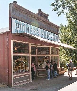 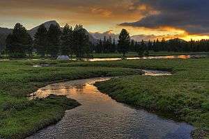 Images, from top down, left to right: The Tuolumne County Courthouse in Sonora, a shop in Columbia State Historic Park, Tuolumne Meadows in Yosemite National Park | |||
| |||
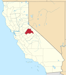 Location in the state of California | |||
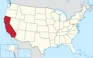 California's location in the United States | |||
| Country |
| ||
| State |
| ||
| Regions | Sierra Nevada, Gold Country | ||
| Incorporated | February 18, 1850[1] | ||
| County seat | Sonora | ||
| Government | |||
| • County Administrator | Craig Pedro | ||
| • Body | Board of Supervisors | ||
| Area | |||
| • Total | 5,890 km2 (2,274 sq mi) | ||
| • Land | 5,750 km2 (2,221 sq mi) | ||
| • Water | 140 km2 (54 sq mi) | ||
| Population (April 1, 2010)[2] | |||
| • Total | 54,179 | ||
| • Estimate (2016)[3] | 54,170 | ||
| • Density | 9.2/km2 (24/sq mi) | ||
| Time zone | UTC-8 (Pacific Time Zone) | ||
| • Summer (DST) | UTC-7 (Pacific Daylight Time) | ||
| Website |
www | ||


Tuolumne County (/tuˈɒləmi/), officially the County of Tuolumne, is a county in the U.S. state of California. As of the 2010 census, the population was 54,179.[2] The county seat and only incorporated city is Sonora.[5]
Tuolumne County comprises the Sonora, CA Micropolitan Statistical Area. The county is in the Sierra Nevada region.
The northern half of Yosemite National Park is located in the eastern part of the county.
Etymology
The name Tuolumne is of Native American origin and has been given different meanings, such as Many Stone Houses, The Land of Mountain Lions and, Straight Up Steep, the latter an interpretation of William Fuller, a native Chief.[6] Mariano Vallejo, in his report to the first California State Legislature, said that the word is "a corruption of the Indian word talmalamne which signifies 'cluster of stone wigwams.'" The name may mean "people who dwell in stone houses," i.e., in caves.
History
Tuolumne County is one of the original counties of California, created in 1850 at the time of statehood. Prior to statehood, it had been referred to as Oro County. Parts of the county were given to Stanislaus County in 1854 and to Alpine County in 1864.
Geography
According to the U.S. Census Bureau, the county has a total area of 2,274 square miles (5,890 km2), of which 2,221 square miles (5,750 km2) is land and 54 square miles (140 km2) (2.4%) is water.[7] A California Department of Forestry document reports Tuolumne County's 1,030,812 acres (4,171.55 km2) include federal lands such as Yosemite National Park, Stanislaus National Forest, Bureau of Land Management lands, and Indian reservations. Notable landforms in the county include Table Mountain.
Special Districts
Special districts in Tuolumne County include:
- Belleview Elementary School District
- Big Oak Flat-Groveland Unified School District
- Chinese Camp Elementary School District
- Columbia Fire District
- Columbia Union Elementary School District
- Curtis Creek Elementary School District
- Groveland Community Services District
- Jamestown Elementary School District
- Jamestown Fire District
- Mi-Wuk Sugar Pine Fire Protection District
- Sonora Elementary School District
- Sonora Union High School District
- Soulsbyville Elementary School District
- Strawberry Fire District
- Summerville Elementary School District
- Summerville Union High School District
- Tuolumne County Air Pollution Control District
- Tuolumne County Water District No. 1
- Tuolumne Fire District
- Tuolumne Regional Water District
- Tuolumne Utilities District
- Twain Harte Fire District
- Twain Harte-Long Barn Union Elementary School District
- Yosemite Community College District
Adjacent counties
- Alpine County, California - north
- Calaveras County, California - northwest
- Stanislaus County, California - southwest
- Mariposa County, California - south
- Madera County, California - southeast
- Mono County, California - east
- Merced County, California - southwest
National protected areas
- Stanislaus National Forest (part)
- Yosemite National Park (part)
Area of Critical Environmental Concern (ACEC)
Transportation
Major highways
Public transportation
Tuolumne County Transit bus routes radiate from Sonora to serve most of the county. In Columbia, a connection can be made to Calaveras County Transit. Yosemite Area Regional Transportation System (YARTS) makes a single daily round trip from Sonora into Yosemite Valley during summer months only. YARTS is set to begin a second daily round trip in June 2013. For details visit www.yarts.com or tuolumnecountytransit.com
Airports
Columbia Airport and Pine Mountain Lake Airport are both general aviation airports located in the Southwest and Northeast corners of the county respectively.
Crime
The following table includes the number of incidents reported and the rate per 1,000 persons for each type of offense.
| Population and crime rates | ||
|---|---|---|
| Population[8] | 55,736 | |
| Violent crime[9] | 158 | 2.83 |
| Homicide[9] | 1 | 0.02 |
| Forcible rape[9] | 25 | 0.45 |
| Robbery[9] | 19 | 0.34 |
| Aggravated assault[9] | 113 | 2.03 |
| Property crime[9] | 669 | 12.00 |
| Burglary[9] | 354 | 6.35 |
| Larceny-theft[9][note 1] | 846 | 15.18 |
| Motor vehicle theft[9] | 100 | 1.79 |
| Arson[9] | 11 | 0.20 |
Cities by population and crime rates
| Cities by population and crime rates | ||||||||
|---|---|---|---|---|---|---|---|---|
| City | Population[10] | Violent crimes[10] | Violent crime rate per 1,000 persons |
Property crimes[10] | Property crime rate per 1,000 persons | |||
| Sonora | 4,804 | 20 | 4.07 | 311 | 63.33 | |||
Demographics
2011
| Population, race, and income | |||||
|---|---|---|---|---|---|
| Total population[8] | 55,736 | ||||
| White[8] | 48,477 | 87.0% | |||
| Black or African American[8] | 1,172 | 2.1% | |||
| American Indian or Alaska Native[8] | 1,008 | 1.8% | |||
| Asian[8] | 605 | 1.1% | |||
| Native Hawaiian or other Pacific Islander[8] | 82 | 0.1% | |||
| Some other race[8] | 2,276 | 4.1% | |||
| Two or more races[8] | 2,116 | 3.8% | |||
| Hispanic or Latino (of any race)[11] | 5,861 | 10.5% | |||
| Per capita income[12] | $26,084 | ||||
| Median household income[13] | $47,359 | ||||
| Median family income[14] | $59,710 | ||||
Places by population, race, and income
| Places by population and race | ||||||||
|---|---|---|---|---|---|---|---|---|
| Place | Type[15] | Population[8] | White[8] | Other[8] [note 2] |
Asian[8] | Black or African American[8] |
Native American[8] [note 3] |
Hispanic or Latino (of any race)[11] |
| Cedar Ridge | CDP | 1,071 | 89.8% | 6.9% | 0.7% | 0.3% | 2.3% | 3.5% |
| Chinese Camp | CDP | 154 | 90.9% | 9.1% | 0.0% | 0.0% | 0.0% | 8.4% |
| Cold Springs | CDP | 293 | 94.2% | 5.8% | 0.0% | 0.0% | 0.0% | 6.5% |
| Columbia | CDP | 2,258 | 74.1% | 20.8% | 0.1% | 0.0% | 5.0% | 11.3% |
| East Sonora | CDP | 2,050 | 89.6% | 5.6% | 1.0% | 0.0% | 3.9% | 7.9% |
| Groveland | CDP | 612 | 97.2% | 2.8% | 0.0% | 0.0% | 0.0% | 0.0% |
| Jamestown | CDP | 4,031 | 89.4% | 10.4% | 0.2% | 0.0% | 0.0% | 19.7% |
| Long Barn | CDP | 353 | 100.0% | 0.0% | 0.0% | 0.0% | 0.0% | 0.0% |
| Mi-Wuk Village | CDP | 761 | 68.3% | 11.8% | 0.8% | 0.0% | 19.1% | 7.6% |
| Mono Vista | CDP | 2,638 | 94.2% | 3.0% | 0.0% | 2.4% | 0.4% | 13.4% |
| Phoenix Lake | CDP | 4,452 | 98.2% | 0.6% | 0.4% | 0.6% | 0.2% | 9.5% |
| Pine Mountain Lake | CDP | 2,695 | 95.5% | 2.3% | 0.9% | 0.0% | 1.3% | 6.8% |
| Sierra Village | CDP | 209 | 100.0% | 0.0% | 0.0% | 0.0% | 0.0% | 0.0% |
| Sonora | City | 4,899 | 93.2% | 3.4% | 1.0% | 1.4% | 0.9% | 5.1% |
| Soulsbyville | CDP | 2,008 | 99.0% | 0.0% | 0.7% | 0.0% | 0.3% | 1.7% |
| Strawberry | CDP | 168 | 100.0% | 0.0% | 0.0% | 0.0% | 0.0% | 0.0% |
| Tuolumne City | CDP | 2,152 | 88.6% | 11.2% | 0.1% | 0.0% | 0.1% | 10.2% |
| Tuttletown | CDP | 903 | 100.0% | 0.0% | 0.0% | 0.0% | 0.0% | 0.0% |
| Twain Harte | CDP | 2,151 | 91.7% | 5.8% | 1.2% | 0.0% | 1.3% | 13.0% |
| Places by population and income | |||||
|---|---|---|---|---|---|
| Place | Type[15] | Population[16] | Per capita income[12] | Median household income[13] | Median family income[14] |
| Cedar Ridge | CDP | 1,071 | $35,230 | $59,323 | $80,833 |
| Chinese Camp | CDP | 154 | $29,125 | $45,313 | $106,250 |
| Cold Springs | CDP | 293 | $34,753 | $74,018 | $88,269 |
| Columbia | CDP | 2,258 | $23,152 | $34,231 | $49,135 |
| East Sonora | CDP | 2,050 | $30,722 | $35,781 | $50,292 |
| Groveland | CDP | 612 | $22,075 | $31,587 | $51,719 |
| Jamestown | CDP | 4,031 | $19,279 | $27,764 | $29,329 |
| Long Barn | CDP | 353 | $38,008 | $24,898 | $16,071 |
| Mi-Wuk Village | CDP | 761 | $32,578 | $60,769 | $81,786 |
| Mono Vista | CDP | 2,638 | $19,865 | $42,328 | $52,835 |
| Phoenix Lake | CDP | 4,452 | $33,759 | $65,292 | $85,365 |
| Pine Mountain Lake | CDP | 2,695 | $31,992 | $54,200 | $64,973 |
| Sierra Village | CDP | 209 | $46,769 | $71,607 | $71,607 |
| Sonora | City | 4,899 | $28,425 | $31,424 | $62,396 |
| Soulsbyville | CDP | 2,008 | $26,181 | $56,853 | $72,750 |
| Strawberry | CDP | 168 | $13,504 | $22,467 | $22,467 |
| Tuolumne City | CDP | 2,152 | $18,620 | $35,291 | $38,509 |
| Tuttletown | CDP | 903 | $20,840 | $31,827 | $45,750 |
| Twain Harte | CDP | 2,151 | $31,264 | $46,250 | $49,911 |
2010
| Historical population | |||
|---|---|---|---|
| Census | Pop. | %± | |
| 1850 | 8,351 | — | |
| 1860 | 16,229 | 94.3% | |
| 1870 | 8,150 | −49.8% | |
| 1880 | 7,848 | −3.7% | |
| 1890 | 6,082 | −22.5% | |
| 1900 | 11,166 | 83.6% | |
| 1910 | 9,979 | −10.6% | |
| 1920 | 7,768 | −22.2% | |
| 1930 | 9,271 | 19.3% | |
| 1940 | 10,887 | 17.4% | |
| 1950 | 12,584 | 15.6% | |
| 1960 | 14,404 | 14.5% | |
| 1970 | 22,169 | 53.9% | |
| 1980 | 33,928 | 53.0% | |
| 1990 | 48,456 | 42.8% | |
| 2000 | 54,501 | 12.5% | |
| 2010 | 55,365 | 1.6% | |
| Est. 2016 | 53,804 | [3] | −2.8% |
| U.S. Decennial Census[17] 1790-1960[18] 1900-1990[19] 1990-2000[20] 2010-2015[2] | |||
The 2010 United States Census reported that Tuolumne County had a population of 55,365. The racial makeup of Tuolumne County was 48,274 (87.2%) White, 1,143 (2.1%) African American, 1,039 (1.9%) Native American, 572 (1.0%) Asian, 76 (0.1%) Pacific Islander, 2,238 (4.0%) from other races, and 2,023 (3.7%) from two or more races. Hispanic or Latino of any race were 5,918 persons (10.7%).[21]
| Population reported at 2010 United States Census | |||||||||
|---|---|---|---|---|---|---|---|---|---|
Population | American | American | Islander | races | more races | or Latino (of any race) | |||
| Tuolumne County | 55,365 | 48,274 | 1,143 | 1,039 | 572 | 76 | 2,238 | 2,023 | 5,918 |
cities and towns | Population | American | American | Islander | races | more races | or Latino (of any race) | ||
| Sonora | 4,903 | 4,402 | 24 | 95 | 79 | 12 | 84 | 207 | 542 |
places | Population | American | American | Islander | races | more races | or Latino (of any race) | ||
| Cedar Ridge | 1,132 | 1,066 | 3 | 6 | 5 | 1 | 5 | 46 | 71 |
| Chinese Camp | 126 | 92 | 0 | 7 | 0 | 0 | 16 | 11 | 25 |
| Cold Springs | 181 | 175 | 1 | 3 | 1 | 0 | 0 | 1 | 4 |
| Columbia | 2,297 | 2,064 | 27 | 26 | 29 | 1 | 27 | 123 | 171 |
| East Sonora | 2,266 | 2,129 | 7 | 16 | 32 | 1 | 35 | 46 | 152 |
| Groveland | 601 | 542 | 2 | 9 | 9 | 2 | 17 | 20 | 49 |
| Jamestown | 3,433 | 2,948 | 20 | 96 | 27 | 4 | 135 | 203 | 511 |
| Long Barn | 155 | 140 | 1 | 3 | 0 | 0 | 5 | 6 | 13 |
| Mi-Wuk Village | 941 | 871 | 5 | 17 | 3 | 0 | 11 | 34 | 71 |
| Mono Vista | 3,127 | 2,796 | 6 | 58 | 38 | 8 | 61 | 160 | 300 |
| Phoenix Lake | 4,269 | 3,991 | 15 | 40 | 50 | 3 | 51 | 119 | 305 |
| Pine Mountain Lake | 2,796 | 2,596 | 18 | 25 | 24 | 7 | 21 | 105 | 183 |
| Sierra Village | 456 | 421 | 3 | 7 | 3 | 1 | 7 | 14 | 36 |
| Soulsbyville | 2,215 | 2,038 | 3 | 41 | 13 | 2 | 38 | 80 | 206 |
| Strawberry | 86 | 82 | 0 | 0 | 0 | 0 | 1 | 3 | 7 |
| Tuolumne City | 1,779 | 1,547 | 13 | 83 | 12 | 1 | 50 | 73 | 206 |
| Tuttletown | 668 | 613 | 5 | 14 | 5 | 1 | 12 | 18 | 48 |
| Twain Harte | 2,226 | 2,026 | 5 | 34 | 31 | 4 | 46 | 80 | 171 |
communities | Population | American | American | Islander | races | more races | or Latino (of any race) | ||
| All others not CDPs (combined) | 21,708 | 17,735 | 985 | 459 | 211 | 28 | 1,616 | 674 | 2,847 |
2000
As of the census[22] of 2000, there were 54,501 people, 21,004 households, and 14,240 families residing in the county. The population density was 9/km² (24/mi²). There were 28,336 housing units at an average density of 5/km² (13/mi²). The racial makeup of the county was 89.5% White, 2.1% Black or African American, 1.8% Native American, 0.7% Asian, 0.2% Pacific Islander, 2.9% from other races, and 2.8% from two or more races. 8.2% of the population were Hispanic or Latino of any race. 94.7% spoke English and 3.5% Spanish as their first language.
There were 21,004 households out of which 26.1% had children under the age of 18 living with them, 54.4% were married couples living together, 9.6% had a female householder with no husband present, and 32.2% were non-families. 26.0% of all households were made up of individuals and 11.70% had someone living alone who was 65 years of age or older. The average household size was 2.36 and the average family size was 2.82.
In the county, the population was spread out with 20.7% under the age of 18, 7.6% from 18 to 24, 25.3% from 25 to 44, 27.9% from 45 to 64, and 18.5% who were 65 years of age or older. The median age was 43 years. For every 100 females there were 111.50 males. For every 100 females age 18 and over, there were 112.20 males.
The median income for a household in the county was $38,725, and the median income for a family was $44,327. Males had a median income of $35,373 versus $25,805 for females. The per capita income for the county was $21,015. About 8.1% of families and 11.4% of the population were below the poverty line, including 16.2% of those under age 18 and 4.0% of those age 65 or over.
County Government and Policing
The Government of Tuolumne County is established and defined by the California Constitution and is a five member elected Board Of Supervisors who serve four year elected terms. The government provides services such as elections and voter registration, law enforcement, jails, vital records, property records, tax collection, public health, and social services. The Board is government for all unincorporated areas. The county seat Sonora is the only incorporated city in Tuolumne County.
Sheriff
The Tuolumne County Sheriff provides court protection, jail administration, and coroner services for the entire county with 55,000 population. It provides patrol and detective services for the unincorporated areas of the county.
Municipal police
There is a municipal police department in Sonora, but the sheriff does the majority of law enforcement.
Politics
Voter registration statistics
| Population and registered voters | ||
|---|---|---|
| Total population[8] | 55,736 | |
| Registered voters[23][note 4] | 32,101 | 57.6% |
| Democratic[23] | 10,306 | 32.1% |
| Republican[23] | 13,529 | 42.1% |
| Democratic–Republican spread[23] | -3,223 | -10.0% |
| Independent[23] | 1,313 | 4.1% |
| Green[23] | 248 | 0.8% |
| Libertarian[23] | 248 | 0.8% |
| Peace and Freedom[23] | 100 | 0.3% |
| Americans Elect[23] | 1 | 0.0% |
| Other[23] | 68 | 0.2% |
| No party preference[23] | 6,288 | 19.6% |
Cities by population and voter registration
| Cities by population and voter registration | |||||||
|---|---|---|---|---|---|---|---|
| City | Population[8] | Registered voters[23] [note 4] |
Democratic[23] | Republican[23] | D–R spread[23] | Other[23] | No party preference[23] |
| Sonora | 4,899 | 55.0% | 38.2% | 32.4% | +5.8% | 10.7% | 22.8% |
Overview
Tuolumne county tends to vote Republican in Presidential and congressional elections. The last Democrat to win the county was Bill Clinton in 1992. In the 2008 presidential election, 14,988 votes were counted for John McCain with former president Barack Obama receiving 11,532 votes.[24]
| Year | GOP | DEM | Others |
|---|---|---|---|
| 2016 | 56.20% 14,551 | 35.23% 9,123 | 8.57% 2,219 |
| 2012 | 56.06% 13,880 | 40.38% 9,998 | 3.55% 880 |
| 2008 | 54.90% 14,988 | 42.24% 11,532 | 2.87% 783 |
| 2004 | 60.02% 15,745 | 38.51% 10,104 | 1.47% 386 |
| 2000 | 55.51% 13,172 | 39.44% 9,359 | 5.04% 1,196 |
| 1996 | 47.27% 10,386 | 40.73% 8,950 | 12.00% 2,636 |
| 1992 | 35.26% 8,525 | 38.12% 9,216 | 26.62% 6,437 |
| 1988 | 54.00% 10,646 | 44.22% 8,717 | 1.79% 352 |
| 1984 | 58.09% 10,485 | 40.35% 7,283 | 1.57% 283 |
| 1980 | 54.85% 8,810 | 33.92% 5,449 | 11.23% 1,804 |
| 1976 | 46.94% 6,104 | 49.93% 6,492 | 3.13% 407 |
| 1972 | 54.29% 5,894 | 42.34% 4,596 | 3.37% 366 |
| 1968 | 47.48% 4,330 | 42.91% 3,913 | 9.61% 876 |
| 1964 | 36.59% 2,861 | 63.16% 4,939 | 0.26% 20 |
| 1960 | 49.11% 3,691 | 50.31% 3,781 | 0.59% 44 |
| 1956 | 52.12% 3,619 | 47.67% 3,310 | 0.20% 14 |
| 1952 | 59.18% 4,050 | 39.96% 2,735 | 0.86% 59 |
| 1948 | 48.21% 2,639 | 46.78% 2,561 | 5.01% 274 |
| 1944 | 41.77% 1,864 | 57.51% 2,566 | 0.72% 32 |
| 1940 | 35.63% 2,004 | 62.96% 3,541 | 1.40% 79 |
| 1936 | 26.40% 1,199 | 72.72% 3,303 | 0.88% 40 |
| 1932 | 30.18% 1,145 | 66.45% 2,521 | 3.37% 128 |
| 1928 | 54.80% 1,731 | 43.05% 1,360 | 2.15% 68 |
| 1924 | 43.03% 1,287 | 11.94% 357 | 45.04% 1,347 |
| 1920 | 59.38% 1,285 | 30.45% 659 | 10.17% 220 |
| 1916 | 36.17% 1,057 | 54.21% 1,584 | 9.62% 281 |
| 1912 | 0.30% 8 | 55.58% 1,459 | 44.11% 1,158 |
| 1908 | 44.40% 943 | 41.34% 878 | 14.27% 303 |
| 1904 | 48.76% 1,280 | 38.32% 1,006 | 12.91% 339 |
| 1900 | 45.09% 1,309 | 52.70% 1,530 | 2.20% 64 |
| 1896 | 38.06% 834 | 59.70% 1,308 | 2.24% 49 |
| 1892 | 40.56% 739 | 50.27% 916 | 9.16% 167 |
Tuolumne County is in California's 4th congressional district, represented by Republican Tom McClintock.[26] In the state legislature Tuolumne is in the 25th Assembly district, which is held by Republican Kristin Olsen, and the 14th Senate district, which is held by Republican Tom Berryhill.
Communities
City
Census-designated places
Unincorporated communities
Population ranking
The population ranking of the following table is based on the 2010 census of Tuolumne County.[27]
† county seat
| Rank | City/Town/etc. | Municipal type | Population (2010 Census)
|
|---|---|---|---|
| 1 | † Sonora | City | 4,903 |
| 2 | Phoenix Lake | CDP | 4,269 |
| 3 | Jamestown | CDP | 3,433 |
| 4 | Mono Vista | CDP | 3,127 |
| 5 | Pine Mountain Lake | CDP | 2,796 |
| 6 | Columbia | CDP | 2,297 |
| 7 | East Sonora | CDP | 2,266 |
| 8 | Twain Harte | CDP | 2,226 |
| 9 | Soulsbyville | CDP | 2,215 |
| 10 | Tuolumne City | CDP | 1,779 |
| 11 | Cedar Ridge | CDP | 1,132 |
| 12 | Mi-Wuk Village | CDP | 941 |
| 13 | Tuttletown | CDP | 668 |
| 14 | Groveland | CDP | 601 |
| 15 | Sierra Village | CDP | 456 |
| 16 | Tuolumne Rancheria[28] | AIAN | 185 |
| 17 | Cold Springs | CDP | 181 |
| 18 | Long Barn | CDP | 155 |
| 19 | Chinese Camp | CDP | 126 |
| 20 | Strawberry | CDP | 86 |
| 21 | Chicken Ranch Rancheria[29] | AIAN | 4 |
See also

- National Register of Historic Places listings in Tuolumne County, California
Notes
- ↑ Only larceny-theft cases involving property over $400 in value are reported as property crimes.
- ↑ Other = Some other race + Two or more races
- ↑ Native American = Native Hawaiian or other Pacific Islander + American Indian or Alaska Native
- 1 2 Percentage of registered voters with respect to total population. Percentages of party members with respect to registered voters follow.
References
- ↑ "Chronology". California State Association of Counties. Retrieved February 6, 2015.
- 1 2 3 "State & County QuickFacts". United States Census Bureau. Retrieved April 6, 2016.
- 1 2 "Population and Housing Unit Estimates". Retrieved June 9, 2017.
- ↑ rar09-mf07 - Gold - $ 12500 SOLD Archived May 14, 2013, at the Wayback Machine., scroll down
- ↑ "Find a County". National Association of Counties. Retrieved 2011-06-07.
- ↑ "Chief Fuller Historical Monument". Twainhartevisitor.com. Retrieved November 7, 2017.
- ↑ "US Gazetteer files: 2010, 2000, and 1990". United States Census Bureau. 2011-02-12. Retrieved 2011-04-23.
- 1 2 3 4 5 6 7 8 9 10 11 12 13 14 15 16 17 U.S. Census Bureau. American Community Survey, 2011 American Community Survey 5-Year Estimates, Table B02001. American FactFinder. Retrieved 2013-10-26.
- 1 2 3 4 5 6 7 8 9 10 Office of the Attorney General, Department of Justice, State of California. Table 11: Crimes – 2009 Archived December 2, 2013, at the Wayback Machine.. Retrieved 2013-11-14.
- 1 2 3 United States Department of Justice, Federal Bureau of Investigation. Crime in the United States, 2012, Table 8 (California). Retrieved 2013-11-14.
- 1 2 U.S. Census Bureau. American Community Survey, 2011 American Community Survey 5-Year Estimates, Table B03003. American FactFinder. Retrieved 2013-10-26.
- 1 2 U.S. Census Bureau. American Community Survey, 2011 American Community Survey 5-Year Estimates, Table B19301. American FactFinder. Retrieved 2013-10-21.
- 1 2 U.S. Census Bureau. American Community Survey, 2011 American Community Survey 5-Year Estimates, Table B19013. American FactFinder. Retrieved 2013-10-21.
- 1 2 U.S. Census Bureau. American Community Survey, 2011 American Community Survey 5-Year Estimates, Table B19113. American FactFinder. Retrieved 2013-10-21.
- 1 2 U.S. Census Bureau. American Community Survey, 2011 American Community Survey 5-Year Estimates. American FactFinder. Retrieved 2013-10-21.
- ↑ U.S. Census Bureau. American Community Survey, 2011 American Community Survey 5-Year Estimates, Table B01003. American FactFinder. Retrieved 2013-10-21.
- ↑ "U.S. Decennial Census". United States Census Bureau. Retrieved May 31, 2014.
- ↑ "Historical Census Browser". University of Virginia Library. Retrieved May 31, 2014.
- ↑ "Population of Counties by Decennial Census: 1900 to 1990". United States Census Bureau. Retrieved May 31, 2014.
- ↑ "Census 2000 PHC-T-4. Ranking Tables for Counties: 1990 and 2000" (PDF). United States Census Bureau. Retrieved May 31, 2014.
- ↑ "2010 Census P.L. 94-171 Summary File Data". United States Census Bureau.
- ↑ "American FactFinder". United States Census Bureau. Retrieved 2011-05-14.
- 1 2 3 4 5 6 7 8 9 10 11 12 13 14 15 16 17 California Secretary of State. February 10, 2013 - Report of Registration Archived July 27, 2013, at the Wayback Machine.. Retrieved 2013-10-31.
- ↑ "Local and National Election Results - Election Center 2008 - Elections & Politics from CNN.com". Cnn.com. Retrieved November 7, 2017.
- ↑ Leip, David. "Dave Leip's Atlas of U.S. Presidential Elections". uselectionatlas.org. Retrieved 2018-09-06.
- ↑ "California's 4th Congressional District - Representatives & District Map". Civic Impulse, LLC. Retrieved March 1, 2013.
- ↑ "Census Coverage Measurement". Census.gov. Retrieved 7 November 2017.
- ↑ "2010 Census Interactive Population Search : Tuolumne Rancheria". Census.gov. Retrieved 7 November 2017.
- ↑ "2010 Census Interactive Population Search : Chicken Ranch Rancheria". Census.gov. Retrieved 7 November 2017.
Further reading
- A Memorial and Biographical History of the Counties of Merced, Stanislaus, Calaveras, Tuolumne and Mariposa, California. Chicago: Lewis Publishing Co., 1892.
- "Tuolumne-Calaveras Unit: 2005 Pre-Fire Management Plan, September 28, 2005 Edition," California Department of Forestry and Fire Protection, 09-28-2005, pp. 16.
- US Department of Education, National Center for Education Statistics.
- CNN News, "Local and National Election Results - Election Center 2008", CNN News, November, 2008.
External links
| Wikimedia Commons has media related to Tuolumne County, California. |
Places adjacent to Tuolumne County, California | ||||||||||
|---|---|---|---|---|---|---|---|---|---|---|
| ||||||||||
Municipalities and communities of Tuolumne County, California, United States | ||
|---|---|---|
| City | | |
| CDPs | ||
| Unincorporated communities | ||
| Ghost towns |
| |

| Authority control |
|---|