Rohnert Park, California
| City of Rohnert Park | ||
|---|---|---|
| City in California | ||
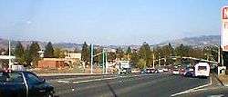
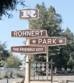 Rohnert Park sign between Commerce Boulevard and U.S. 101 | ||
| ||
| Motto(s): "The Friendly City" | ||
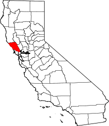
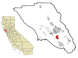 Location in Sonoma County and the U.S. state of California | ||
 City of Rohnert Park Location in the United States | ||
| Coordinates: 38°20′50″N 122°41′43″W / 38.34722°N 122.69528°WCoordinates: 38°20′50″N 122°41′43″W / 38.34722°N 122.69528°W | ||
| Country |
| |
| State |
| |
| County | Sonoma | |
| Incorporated | August 28, 1962[1] | |
| Government | ||
| • Type | Council–manager[2] | |
| • Mayor | Pam Stafford | |
| • Vice Mayor | Joseph T. Callinan | |
| • City Manager | Darrin Jenkins[3] | |
| Area[4] | ||
| • Total | 7.01 sq mi (18.15 km2) | |
| • Land | 7.00 sq mi (18.14 km2) | |
| • Water | 0.01 sq mi (0.01 km2) 0.07% | |
| Elevation[5] | 105 ft (32 m) | |
| Population (2010) | ||
| • Total | 40,971 | |
| • Estimate (2016)[6] | 42,622 | |
| • Density | 6,086.25/sq mi (2,349.80/km2) | |
| Time zone | UTC−8 (Pacific) | |
| • Summer (DST) | UTC−7 (PDT) | |
| ZIP codes[7] | 94926–94928 | |
| Area code | 707 | |
| FIPS code | 06-62546 | |
| GNIS feature IDs | 1656263, 2410985 | |
| Website |
www | |
Rohnert Park is a city in Sonoma County, California, United States, located approximately 50 miles (80 km) north of San Francisco. The population at the 2010 United States Census was 40,971. It is an early planned city and is the sister city of Hashimoto in Japan.[8] Sonoma State University, part of the California State University system, is located nearby.
Geography
According to the United States Census Bureau, Rohnert Park has a total area of 7.0 square miles (18 km2), 99.93% of it land and 0.07% of it water.
Hydrology
There is a small reservoir called Roberts Lake at the north end of the city as well as a number of creeks. Important creeks include the Laguna de Santa Rosa (which forms part of the border with the City of Cotati), Copeland Creek, Hinebaugh Creek, Crane Creek and Five Creek.
All creeks within the city limits have been channelized. Spivock Creek, Coleman Creek, Wilfred Channel, and Labath Channel are artificial channels designed to convey runoff.
Geology
The Rodgers Creek Fault is an active fault influencing earthquake activity in the Rohnert Park area.[9] The city also experiences earthquakes from the San Andreas Fault.
Sections
The city is organized into sections, designated by the letters A–H, "J", "L", "M", "R", and "S." In most cases, the names of streets and parks begin with the letter of the section they are in.[10]
Biology
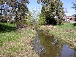
Riparian communities within the city are limited by channelization of creekbeds. Vegetation alongside the City's streams primarily consists of grass and sedge species. The Laguna de Santa Rosa contains bands of thick native riparian vegetation, including willow (Salix spp.) and alder (Alnus spp.) trees.[11]
Sudden oak death fungus risks are present in the Rohnert Park area. Research is ongoing at the nearby Fairfield Osborn Preserve.[12]
Demographics
| Historical population | |||
|---|---|---|---|
| Census | Pop. | %± | |
| 1970 | 6,133 | — | |
| 1980 | 22,965 | 274.4% | |
| 1990 | 36,326 | 58.2% | |
| 2000 | 42,236 | 16.3% | |
| 2010 | 40,971 | −3.0% | |
| Est. 2016 | 42,622 | [6] | 4.0% |
| U.S. Decennial Census[13] | |||

2010
The 2010 United States Census[14] reported that Rohnert Park had a population of 40,971. The population density was 5,846.8 people per square mile (2,257.5/km²). The racial makeup of Rohnert Park was 31,178 (76.1%) White (66.2% non-Hispanic white), 759 (1.9%) African American, 407 (1.0%) Native American, 2,144 (5.2%) Asian (1.3% Filipino, 1.0% Chinese, 0.8% Indian, 0.4% Vietnamese, 0.4% Japanese, 0.4% Korean, 0.2% Laotian, 0.1% Cambodian, 0.1% Thai, 0.1% Nepalese), 179 (0.4%) Pacific Islander (0.1% Samoan, 0.1% Native Hawaiian, 0.1% Fijian, 0.1% Tongan), 3,967 (9.7%) from other races, and 2,337 (5.7%) from two or more races. Hispanic or Latino of any race were 9,068 persons (22.1%). Among the Hispanic population, 17.3% are Mexican, 1.0% are Salvadoran, 0.6% Puerto Rican, and 0.4% Guatemalan.
The Census reported that 99.0% of the population lived in households and 1.0% lived in non-institutionalized group quarters.
There were 15,808 households, out of which 4,842 (30.6%) had children under the age of 18 living in them, 6,546 (41.4%) were opposite-sex married couples living together, 1,883 (11.9%) had a female householder with no husband present, 907 (5.7%) had a male householder with no wife present. There were 1,201 (7.6%) unmarried opposite-sex partnerships, and 144 (0.9%) same-sex married couples or partnerships. 4,177 households (26.4%) were made up of individuals and 1,374 (8.7%) had someone living alone who was 65 years of age or older. The average household size was 2.57. There were 9,336 families (59.1% of all households); the average family size was 3.13.
The population was spread out with 8,571 people (20.9%) under the age of 18, 6,853 people (16.7%) aged 18 to 24, 11,035 people (26.9%) aged 25 to 44, 10,710 people (26.1%) aged 45 to 64, and 3,802 people (9.3%) who were 65 years of age or older. The median age was 33.0 years. For every 100 females, there were 95.3 males. For every 100 females age 18 and over, there were 92.7 males.
There were 16,551 housing units at an average density of 2,361.9 per square mile (911.9/km²), of which 54.0% were owner-occupied and 46.0% were occupied by renters. The homeowner vacancy rate was 2.1%; the rental vacancy rate was 4.8%. 55.8% of the population lived in owner-occupied housing units and 43.3% lived in rental housing units.
2000
As of the census[15] of 2000, there were 42,236 people, 15,503 households, and 9,797 families residing in the city. The population density was 6,564.5 people per square mile (2,534.6/km²). There were 15,808 housing units at an average density of 2,457/sq mi (949/km²). The racial makeup of the city was 80.28% White, 1.97% African American, 0.78% Native American, 5.58% Asian, 0.42% Pacific Islander, 5.72% from other races, and 5.25% from two or more races. Hispanic or Latino of any race were 13.57% of the population.
There were 15,503 households out of which 35.1% had children under the age of 18 living with them, 46.7% were married couples living together, 11.9% had a female householder with no husband present, and 36.8% were non-families. 24.0% of all households were made up of individuals and 7.7% had someone living alone who was 65 years of age or older. The average household size was 2.65 and the average family size was 3.20.
In the city, the population was spread out with 25.3% under the age of 18, 14.8% from 18 to 24, 32.0% from 25 to 44, 19.8% from 45 to 64, and 8.1% who were 65 years of age or older. The median age was 32 years. For every 100 females, there were 94.1 males. For every 100 females age 18 and over, there were 90.2 males. The median income for a household in the city was $51,942, and the median income for a family was $61,420. Males had a median income of $41,757 versus $31,149 for females. The per capita income for the city was $23,035. About 3.2% of families and 8.0% of the population were below the poverty line, including 4.6% of those under age 18 and 6.3% of those over age 64.
Law and government
City council
Rohnert Park is governed by a city council of five members, who serve staggered four-year terms. Municipal elections are held in November of even-numbered years.[16]
County, state, and federal representation
Rohnert Park is split between Sonoma County's 2nd and 3rd supervisorial districts.[17][18]
In the California State Legislature, Rohnert Park is in the 3rd Senate District, represented by Democrat Bill Dodd,[19] and in the 4th Assembly District, represented by Democrat Cecilia Aguiar-Curry.[20]
In the United States House of Representatives, Rohnert Park is part of California's 5th congressional district, represented by Democrat Mike Thompson.[21]
Department of Public Safety
Rohnert Park is patrolled by the Rohnert Park Department of Public Safety, established in 1962, that operates as an integrated fire and police department.
Shooting of Kuanchung Kao
On April 29, 1997, Kuanchung Kao was waving a wooden stick in the street in front of his driveway, prompting 911 calls placed by his neighbors, and two officers, Jack Shields and Mike Lynch, responded to the scene. Shields shot Kao once in the chest. Shields stated that he believed Kao was waving the stick in a martial arts fashion, and that he and Lynch had to respond by using deadly force. The incident was investigated by the Sonoma County Sheriff's Office, the Sonoma County District Attorney's Office, and FBI, who all cleared Shields. Kao's family and attorney John Burris filed a lawsuit against the city of Rohnert Park, and received a settlement of $1 million in 2001.
2015 police controversy
On July 29, 2015, Rohnert Park Public Safety Officer Dave Rodriguez[22] drew his sidearm during an encounter with city resident Don McComas,[23] while McComas was hitching his boat trailer to his vehicle.[24] McComas recorded the incident and posted it on YouTube.[25][26]
Officer Rodriguez was placed on administrative leave while the city conducted an internal investigation into the incident.[27] On August 6, 2015, the city announced that it would engage an independent investigator.[28] In October 2015, the city announced the investigators’ findings that Rodriguez’ actions were within the law and followed department policy, stating it was “reasonable” for Rodriguez “to un-holster his duty weapon at the point he did during the encounter with the resident.”[29]
McComas was not detained or arrested during or after the incident.[30] A civil rights claim has been filed on behalf of McComas claiming that Rodriguez was trying to intimidate him.[22]
History
Originally home of the Coast Miwok native people,[31] the Mexican government granted Rancho Cotate to Captain Juan Castaneda in July 1844 for his military services in the region. The grant encompassed present-day Penngrove, Cotati and Rohnert Park. "Cotate Rancho is a part of the Vallejo Township which is the plain between Sonoma Mountain and Petaluma Creek San Pablo Bay, and an east and west line dividing the tract from Santa Rosa Township."[32][33] In 1849, Dr. Thomas S. Page, of Cotati, bought Rancho Cotate. Over time, the property was broken up and sold off piecemeal to incoming settlers.[32]
The town of Rohnert Park was named after the Rohnert family, which owned the Rohnert Seed Farm. In 1929, a successful businessman, Waldo Emerson Rohnert (1869–1933), a native of Detroit, Michigan, purchased a large ranch in the area and minimized flooding in the fields with a crude drainage system. He died shortly thereafter. His son, Fred Rohnert, a graduate of Stanford Law School, took over the ranch and developed a seed growing business, the Rohnert Seed Farm, which became a major horticultural success for the county.[32]
In 1956, only four adults resided within the district boundaries. In 1956 and 1957, with the U.S. Route 101 Freeway recently completed at the Cotati bypass, Rohnert Park began to be laid out and built as a planned city. In a summer election in 1962, Rohnert Park was incorporated, comprising 1,325 acres (536 ha), housing an estimated 2,775 persons. It was the first town to incorporate in Sonoma County since 1905. The neighboring town of Cotati, California, voted to incorporate the following year.[32]
Transportation
Rohnert Park is served by a station on the Sonoma–Marin Area Rail Transit commuter rail line since it become operational August 25, 2017. Sonoma County Airport Express buses connect Rohnert Park with Oakland International Airport and San Francisco International Airport.[34]
Education
The Cotati-Rohnert Park Unified School District serves the city, which is also home to Sonoma State University.
High schools
Rancho Cotate High School is the main comprehensive high school for both Rohnert Park and Cotati. Technology High School is a small public high school located on the Sonoma State University campus.
Alternative education consists of:
- Credo High School, A Charter Public High School, in Sonoma County, inspired by Waldorf Education, offers a tuition-free, holistic, college prep curriculum and specialty subjects.
- Flex Academy (on RCHS campus)
- Technology High School
- Phoenix High School (on RCHS campus)
- Independent study
21st-century development
Sonoma Mountain Village Rohnert Park is a 200-acre (0.81 km2), solar-powered, zero-waste community currently under development.[35]
The Graton Resort & Casino opened on November 5, 2013.
See also
Notes
- ↑ "California Cities by Incorporation Date". California Association of Local Agency Formation Commissions. Archived from the original (Word) on November 3, 2014. Retrieved August 25, 2014.
- ↑ "Government". City of Rohnert Park, California. Retrieved January 30, 2015.
- ↑ "City Manager - City of Rohnert Park". Retrieved November 26, 2016.
- ↑ "2016 U.S. Gazetteer Files". United States Census Bureau. Retrieved Jun 28, 2017.
- ↑ "Rohnert Park". Geographic Names Information System. United States Geological Survey. Retrieved November 3, 2014.
- 1 2 "Population and Housing Unit Estimates". Retrieved June 9, 2017.
- ↑ "ZIP Code(tm) Lookup". United States Postal Service. Retrieved November 24, 2014.
- ↑ "Sister Cities Relations Committee". City of Rohnert Park, California. Retrieved January 5, 2015.
- ↑ USGS, Seismicity in the Rohnert Park, California vicinity
- ↑ "Sonoma County Homes For Sale". Cynthia Larson. Retrieved November 28, 2014.
- ↑ Earth Metrics, Environmental Impact Report for the City of Rohnert Park General Plan, C Michael Hogan, Marc Papineau, Ballard George et al., published by the city of Rohnert Park, California and the State of California Environmental Clearinghouse, Sacramento, Ca., Report Number 10351, March 9, 1990
- ↑ Sonoma State University research study on Sudden Oak Death Fungus at Fairfield Osborn Preserve (2000)
- ↑ "Census of Population and Housing". Census.gov. Retrieved June 4, 2015.
- ↑ "2010 Census Interactive Population Search: CA - Rohnert Park city". U.S. Census Bureau. Retrieved July 12, 2014.
- ↑ "American FactFinder". United States Census Bureau. Retrieved 2008-01-31.
- ↑ "City of Rohnert Park, California : Government". Retrieved August 24, 2010.
- ↑ "Board of Supervisors - District 2". County of Sonoma. Retrieved January 8, 2014.
- ↑ "Board of Supervisors - District 3". County of Sonoma. Retrieved January 8, 2014.
- ↑ "Senators". State of California. Retrieved August 25, 2014.
- ↑ "Members Assembly". State of California. Retrieved August 25, 2014.
- ↑ "California's 5th Congressional District - Representatives & District Map". Civic Impulse, LLC. Retrieved August 25, 2014.
- 1 2 http://abc7news.com/news/rohnert-park-officer-being-sued-for-drawing-gun-on-man/911687/
- ↑ http://www.nbcbayarea.com/news/local/Rohnert-Park-Police-Officer-Who-Pulled-Gun-on-Man-Placed-on-Paid-Administrative-Leave-320989391.html
- ↑ http://www.nydailynews.com/news/national/calif-pulls-gun-man-recording-video-article-1.2316656
- ↑ https://www.youtube.com/watch?v=9cDy3tUy4Io
- ↑ http://www.cnn.com/videos/us/2015/08/07/cop-confrontation-goes-viral-pulls-gun-orig.cnn
- ↑ http://www.latimes.com/local/lanow/la-me-ln-northern-california-cop-pulls-gun-on-man-recording-him-20150807-story.html
- ↑ http://www.rpcity.org/index.aspx?page=28&recordid=1189&returnURL=%2findex.aspx
- ↑ http://www.pressdemocrat.com/news/6229218-181/crimebeat-what-became-of-the?ref=most
- ↑ http://www.dailymail.co.uk/news/article-3186904/Shocking-moment-Northern-California-officer-pulls-gun-man-recording-cellphone.html
- ↑ Access Genealogy
- 1 2 3 4 DeClercq, 1977.
- ↑ Harris, 1980.
- ↑ Sonoma County Airport Express Website
- ↑ Peters, Adele (February 19, 2009). "Sonoma Mountain Village: Is Green Suburbia Possible?". worldchanging. Archived from the original on February 22, 2009. Retrieved February 19, 2009.
References
- "Access Genealogy: Indian Tribal records, Miwok Indian Tribe. Retrieved on 2006-08-06. A list of all verified Coastal Miwok villages in the area.
- DeClercq, John H. A History of Rohnert Park "from seed to city" , 1977. Retrieved on 2006-08-06.
- Harris, Ellen. "Penngrove: A Jigsaw Puzzle of its Past and Present." Penngrove, California: n.p.[Private Publication], 1980.
External links
| Wikimedia Commons has media related to Rohnert Park, California. |
| Wikivoyage has a travel guide for Rohnert Park. |
- Official website

- Cotati-Rohnert Park Unified School District
- Sonoma State University
- The Press Democrat Online: News for Rohnert Park and the Surrounding Sonoma Region
- The Community Voice: Rohnert Park, Cotati and Penngrove
Places adjacent to Rohnert Park, California | |
|---|---|
| Bodies of water |
|  |
|---|---|---|
| Counties | ||
| Major cities | ||
| Cities and towns 100k–250k | ||
| Cities and towns 50k–99k | ||
| Cities and towns 25k-50k | ||
| Cities and towns 10k–25k |
| |
| Sub-regions | ||