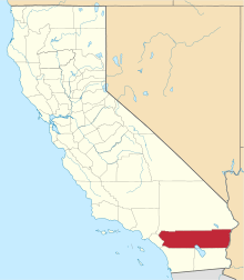
Jurupa Valley, California
| Jurupa Valley, California | ||
|---|---|---|
| City | ||
| City of Jurupa Valley | ||
| ||
| Nickname(s): "Jurupa", "JuVal" | ||
 Jurupa Valley, California Location in the United States | ||
| Coordinates: 34°00′N 117°29′W / 34.000°N 117.483°WCoordinates: 34°00′N 117°29′W / 34.000°N 117.483°W | ||
| Country |
| |
| State |
| |
| County |
| |
| Incorporated (city) | July 1, 2011[1] | |
| Government | ||
| • Type | Council-Manager | |
| • Mayor | Verne Lauritzen | |
| • City Council |
Council members
| |
| Area[2] | ||
| • City | 43.68 sq mi (113.12 km2) | |
| • Land | 42.94 sq mi (111.22 km2) | |
| • Water | 0.74 sq mi (1.91 km2) | |
| Population (2010) | ||
| • City | 95,005 (US: 294th) | |
| • Estimate (2017)[3] | 106,028 | |
| • Density | 2,411.24/sq mi (930.99/km2) | |
| • Metro | 4,527,837 | |
| Time zone | UTC-8 (PST) | |
| • Summer (DST) | UTC-7 (PDT) | |
| ZIP codes | 92509, 91752 | |
| Area code(s) | 951 | |
| FIPS code | 06-37692 | |
| GNIS feature ID | 2702867 | |
| Website |
jurupavalley | |

Jurupa Valley is a city in Riverside County, California. It is located next to Eastvale. On March 8, 2011, voters approved a ballot measure, designated as Measure A, to incorporate the area into its own city; as a result, the area has been an incorporated city since July 1, 2011.[4]
The city of Jurupa Valley covers approximately 43.5 square miles (113 km2), and has an estimated population of 103,541.
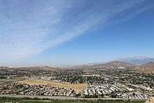
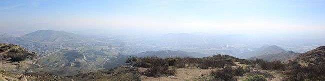
Geography
It is north and west of the Santa Ana River, south of the Riverside-San Bernardino County line, and east of Interstate 15. It includes the neighborhoods of Mira Loma, Glen Avon, Sky Country, Indian Hills, Pedley, Rubidoux, Belltown, Jurupa, Jurupa Hills, and Sunnyslope. Residents of the area had previously voted on incorporation in 1992; however, voters rejected it as well as a competing ballot measure that would have incorporated Mira Loma.[4]
| Climate data for Jurapa Valley, California | |||||||||||||
|---|---|---|---|---|---|---|---|---|---|---|---|---|---|
| Month | Jan | Feb | Mar | Apr | May | Jun | Jul | Aug | Sep | Oct | Nov | Dec | Year |
| Record high °F (°C) | 91 (33) |
92 (33) |
100 (38) |
101 (38) |
107 (42) |
110 (43) |
110 (43) |
112 (44) |
115 (46) |
108 (42) |
99 (37) |
92 (33) |
115 (46) |
| Average high °F (°C) | 67 (19) |
68 (20) |
71 (22) |
77 (25) |
80 (27) |
88 (31) |
93 (34) |
95 (35) |
91 (33) |
83 (28) |
74 (23) |
69 (21) |
80 (27) |
| Average low °F (°C) | 42 (6) |
44 (7) |
46 (8) |
48 (9) |
53 (12) |
58 (14) |
64 (18) |
66 (19) |
62 (17) |
53 (12) |
45 (7) |
42 (6) |
52 (11) |
| Record low °F (°C) | 24 (−4) |
27 (−3) |
28 (−2) |
31 (−1) |
32 (0) |
44 (7) |
49 (9) |
48 (9) |
42 (6) |
31 (−1) |
26 (−3) |
23 (−5) |
22 (−6) |
| Average precipitation inches (mm) | 3.45 (87.6) |
3.62 (91.9) |
2.91 (73.9) |
.88 (22.4) |
.26 (6.6) |
.03 (0.8) |
.05 (1.3) |
.15 (3.8) |
.27 (6.9) |
.56 (14.2) |
1.34 (34) |
2.72 (69.1) |
16.24 (412.5) |
| Average precipitation days | 6.6 | 7.2 | 5.3 | 3.5 | 1.4 | 0.3 | 0.8 | 1.0 | 1.3 | 2.5 | 4.4 | 6.4 | 40.7 |
Demographics
| Historical population | |||
|---|---|---|---|
| Census | Pop. | %± | |
| 2010 | 95,005 | — | |
| Est. 2017 | 106,028 | [3] | 11.6% |
| U.S. Decennial Census[5] | |||
Jurupa Valley was incorporated after the 2010 United States Census, but it is possible to determine an estimated population by summing up the results from the census-designated places of Glen Avon, Mira Loma, Pedley, Rubidoux and Sunnyslope.
According to the United States Census Bureau the 2014 estimated population was 98,842.[6]
Education
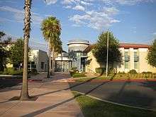
Jurupa Valley is home to the Jurupa Unified School District. The district operates 16 Elementary Schools, 4 Middle Schools, 3 Continuation Schools, and 4 High Schools, including:[7]
- Jurupa Valley High School
- Rubidoux High School
- Patriot High School
- Rivercrest Preparatory
Transportation
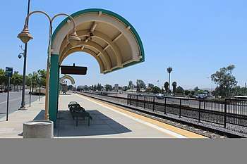
Public Transportation in Jurupa Valley is provided by Riverside Transit Agency.[8] Also, Jurupa Valley/Pedley station (formerly Pedley Station) is served by Metrolink, and the city is served by Ontario International Airport.
Some major roads in Jurupa Valley include Interstate 15 and California State Route 60.
References
- ↑ "News : Press Enterprise". pe.com.
- ↑ "2016 U.S. Gazetteer Files". United States Census Bureau. Retrieved Jul 19, 2017.
- 1 2 "Population and Housing Unit Estimates". Retrieved August 29, 2018.
- 1 2 Stokley, Sandra (8 March 2011). "Jurupa cityhood approved". The Press-Enterprise. Retrieved 9 March 2011.
- ↑ "Census of Population and Housing". Census.gov. Archived from the original on June 24, 2017. Retrieved June 24, 2017.
- ↑ http://quickfacts.census.gov/qfd/states/06/0637692.html
- ↑
- ↑ "City of Jurupa Valley > Residents > Transportation". jurupavalley.org. Retrieved 24 September 2018.
External links
| Wikivoyage has a travel guide for Jurupa Valley. |
- City of Jurupa Valley
- Jurupa Unified School District web site
- Jurupa Valley Measure A official sample ballot
Places adjacent to Jurupa Valley, California | |
|---|---|