Eastern California
| Eastern California | |
| Region | |
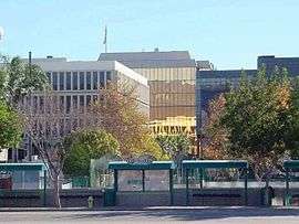 Downtown San Bernardino, anchor of the largest metro area in East California and 12th in the United States. | |
| Country | United States |
|---|---|
| State | California |
| Highest point | Mount Whitney |
| - location | Inyo County |
| - elevation | 14,505 ft (4,421 m) |
| - coordinates | 36°34′42.89″N 118°17′31.18″W / 36.5785806°N 118.2919944°W |
| Lowest point | Badwater Basin[1] |
| - location | Inyo County |
| - elevation | −279 ft (−85 m) |
| - coordinates | 36°14′23.93″N 116°49′54.16″W / 36.2399806°N 116.8317111°W |
| Timezone | Pacific Standard Time |
| - summer (DST) | Pacific Daylight Time |
| Area code | 530, 442/760, 909, 951 |
 Counties on California's Eastern Border | |
Eastern California is a region defined as either the strip to the east of the crest of the Sierra Nevada or as the easternmost counties of California in the United States.
Demographics
According to the 2010 census, the population of the easternmost counties of California was 5,129,384. However, a single metropolitan area, consisting of San Bernardino and Riverside counties, has a population of 4,224,851.
Culture and history
Most of Eastern California does not fit the stereotypes of California and is more related in culture to southeastern Oregon, northwestern Nevada, and western Arizona. Northeastern California is very sparsely populated (except for the area around Lake Tahoe) and tends to be politically conservative, much like the rest of the rural Western United States. However, the counties of San Bernardino and Riverside form the 12th largest metropolitan area of the United States, and the counties of El Dorado, Placer, and Nevada are part of the Greater Sacramento area and are culturally influenced by their respective metropolitan areas.
Historically, Northeastern California has had strong ties to Nevada, with the exact boundary between the two states in some dispute.[2] Residents of portions of near Susanville, California, tried to break away from California in 1856, first by declaring themselves part of the Nataqua Territory[3] and then through annexation to Nevada. The two states further squabbled over ownership of Susanville in 1863. The town of Aurora, Nevada, was temporarily the county seat of both Mono County, California, and Esmeralda County, Nevada. Finally, the line between the two states was settled by a survey in 1872.
Geography
The easternmost counties of California are (from north to south) :
Cities within this region include San Bernardino, Riverside, Ontario, Rancho Cucamonga, Roseville, Victorville, Temecula, Palm Springs, Lincoln, El Centro, Barstow, South Lake Tahoe, Susanville, Truckee, Grass Valley, Placerville, and Alturas
Geology
Because Eastern California is generally in the rain shadow of the Sierra Nevada or the Transverse Ranges, the climate is extremely dry and can be considered a desert. Indeed, the hottest and lowest area in North America lies in Eastern California: Death Valley.
Geologically, Eastern California is mostly part of the Basin and Range Province, marked by crustal extension, with horsts and grabens. Volcanism is also very evident in this region.
See also
References
- ↑ "USGS National Elevation Dataset (NED) 1 meter Downloadable Data Collection from The National Map 3D Elevation Program (3DEP) - National Geospatial Data Asset (NGDA) National Elevation Data Set (NED)". United States Geological Survey. September 21, 2015. Retrieved September 22, 2015.
- ↑ Bruce A. Metcalfe. "A Moving Monument". Retrieved 2006-03-28.
- ↑ "US395:Lassen County (Susanville to Modoc County Line)". Floodgap Roadgap. Retrieved 2006-04-01.
