Pittsburg, California
| City of Pittsburg (formerly) Black Diamond and New York of the Pacific[1] | |
|---|---|
| City | |
 | |
| Nickname(s): "P-World" "The Burg" | |
| Motto(s): Gateway to the Delta! | |
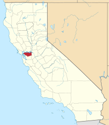
 Location in Contra Costa County and the state of California | |
 City of Pittsburg Location in the United States | |
| Coordinates: 38°01′41″N 121°53′05″W / 38.02806°N 121.88472°WCoordinates: 38°01′41″N 121°53′05″W / 38.02806°N 121.88472°W | |
| Country | United States |
| State | California |
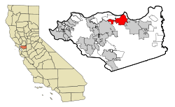
| County | Contra Costa |
| Incorporated | June 25, 1903[2] |
| Government | |
| • Type | General Law City |
| • Mayor | Marilyn Craft [3] |
| • State Senator | Steve Glazer (D)[4] |
| • State Assembly |
Jim Frazier (D) and Tim Grayson (D)[5] |
| • U. S. Congress | Mark DeSaulnier (D)[6] |
| Area[7] | |
| • Total | 19.15 sq mi (49.59 km2) |
| • Land | 17.19 sq mi (44.52 km2) |
| • Water | 1.96 sq mi (5.07 km2) 10.11% |
| Elevation[8] | 26 ft (8 m) |
| Population (2010) | |
| • Total | 63,264 |
| • Estimate (2016)[9] | 70,679 |
| • Density | 4,111.87/sq mi (1,587.63/km2) |
| Time zone | UTC-8 (PST) |
| • Summer (DST) | UTC-7 (PDT) |
| ZIP code | 94565 |
| Area code(s) | 925 |
| FIPS code | 06-57456 |
| GNIS feature IDs | 1659783, 2411430 |
| Website |
www |
Pittsburg is an industrial suburb city in Contra Costa County, California. The population was 63,264 at the 2010 census. It is located on the southern shore of the Suisun Bay in the East Bay region of the San Francisco Bay Area, and is part of the Sacramento–San Joaquin River Delta area.
History
In 1849, Colonel Jonathan D. Stevenson (from New York) bought the Rancho Los Medanos land grant, and laid out a town he called New York of the Pacific.[10] By 1850, this venture failed.[10] With the discovery of coal in the nearby town of Nortonville, the place became a port for coaling, and adopted the name Black Diamond, after the mining firm[10] that built the Black Diamond Coal Mining Railroad from there to Nortonville.[11] Because of the industrial potential of the site, a name change to Pittsburg was proposed in 1909.[10]
Pittsburg, originally settled in 1839, was called first "New York Landing", then "Black Diamond", before citizens voted on "Pittsburg" on February 11, 1911. The name was selected to honor Pittsburgh, Pennsylvania, as the two cities' shared a common steel and mining industrial heritage.[12] This rechristening came at a time when the name of Pittsburgh, Pennsylvania was more commonly spelled without the "h".[13]
_(14778670061).jpg)
In 1910, Columbia Steel opened its California steel plant in Pittsburg with one foundry and a crew of 60 employees. It made steel castings for the dredging, lumber and shipping industries. In 1930, Columbia became a subsidiary of U.S. Steel Company. The plant continued to grow until the early 1950s, reaching a peak staff of 5,200 employees. when the markets for its products crashed. The parent company (by 1986, renamed as USS Company) had merged with Korean Pohang Iron and Steel Company. Together they invested $450 million turning the Pittsburg plant into a modern flat-products mill, renamed as USS-Posco. As of 1999, the facility employed 970 workers and shipped over 1.6 million U.S. tons per year of steel to over 175 customers in the Western U. S., Mexico, Canada and the Pacific Rim.[14]
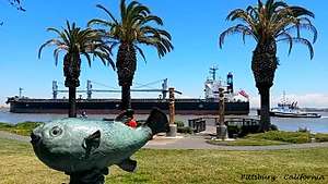
The original town site fronts on the Sacramento/San Joaquin River Delta, reflecting its origins as a deep water channel river port. (As of January 1, 2007, state legislation [Assembly Bill 2324] enabled the city to manage its own riverfront for commercial development and subsequent port operations). Since the early 1900s, the city has grown inland to the south, then spread east and west along State Route 4, now a freeway carrying resident commuters to jobs in the San Francisco Bay-Oakland Region. In the process, the former town of Cornwall, California was absorbed. The city has enjoyed continued residential redevelopment growth near its northern boundary, as well as ongoing construction of major subdivisions in the southwest hills, including San Marco Villas. As of the 2000 census, the city had a total population of 56,769.[15]
Camp Stoneman, located in the area, was a major staging area for the United States Army during World War II and the Korean War.
The post office first opened in 1868 as Black Diamond, and changed its name with the town's in 1911.[10]
During the early 1900s, many Sicilian fishermen from Isola delle Femmine near Palermo settled in what would become Pittsburg.
Economy
The city has an extensive history of coal mining and industrial development since the late 1800s, with USS-POSCO Industries (a joint venture between US Steel and POSCO of South Korea) and Dow Chemical Company maintaining substantial plants in Pittsburg.[14] Ramar International manufactures Magnolia Dairy Ice Cream, a Philippine specialty brand, in Pittsburg.
Top employers
According to the City's 2009 Comprehensive Annual Financial Report,[16] the top employers in the city are:
| # | Employer | # of Employees |
|---|---|---|
| 1 | Pittsburg Unified School District | 965 |
| 2 | USS-POSCO Industries | 700 |
| 3 | Los Medanos College | 640 |
| 4 | Dow Chemical Company | 400 |
| 5 | City of Pittsburg | 268 |
| 6 | Mi Pueblo Foods | 250 |
| 7 | Angelica | 220 |
| 7 | Ramar Foods | 220 |
| 7 | Wal-Mart | 220 |
| 10 | WinCo Foods | 200 |
Geography
The city of Pittsburg is located 37 miles northeast from San Francisco, 29 miles northeast from Oakland, California, 60 miles north of San Jose and 65 miles south of Sacramento, California. Pittsburg shares a border with the unincorporated community of Bay Point, California to the west, the city of Concord, California to the southwest and Antioch, California to the east. The Suisun Bay is directly north of the city and connects the San Francisco Bay to the Sacramento and San Joaquin rivers.[17][18]
Climate
Pittsburg experiences a hot summer Mediterranean climate (Köppen climate classification Csa) bordering on the Semi-arid climate because of the Mt. Diablo rain shadow in East Contra Costa County.[19]
| Climate data for Pittsburg, California | |||||||||||||
|---|---|---|---|---|---|---|---|---|---|---|---|---|---|
| Month | Jan | Feb | Mar | Apr | May | Jun | Jul | Aug | Sep | Oct | Nov | Dec | Year |
| Average high °F (°C) | 57.6 (14.2) |
60.1 (15.6) |
71.1 (21.7) |
79 (26.1) |
86 (30.0) |
91 (32.8) |
90 (32.2) |
86 (30.0) |
78.1 (25.6) |
64.9 (18.3) |
64 (17.8) |
54 (12.2) |
73 (22.8) |
| Average low °F (°C) | 37.9 (3.3) |
41 (5.0) |
46.9 (8.3) |
52 (11.1) |
57 (13.9) |
57.9 (14.4) |
57.9 (14.4) |
55.9 (13.3) |
51.1 (10.6) |
44.1 (6.7) |
44.1 (6.7) |
36 (2.2) |
48.6 (9.2) |
| Average precipitation inches (mm) | 2.72 (69.1) |
2.51 (63.8) |
2.16 (54.9) |
0.73 (18.5) |
0.47 (11.9) |
0.09 (2.3) |
0.03 (0.8) |
0.03 (0.8) |
0.24 (6.1) |
0.76 (19.3) |
1.77 (45) |
1.89 (48) |
13.33 (338.6) |
| Source: [20] | |||||||||||||
Transportation
The city has two BART stations, the Pittsburg/Bay Point Station located on Bailey Road and Highway 4 near Bay Point and the Pittsburg Center Station located on Railroad Avenue and Highway 4.[21] Tri Delta Transit provides bus service in the area. California State Route 4 bisects the city from west to east.
Education
Pittsburg is home to Los Medanos College,[22] a two-year community college that is part of the Contra Costa Community College District. The college's name is derived from that of Rancho Los Medanos, one of the land grants made by the Mexican Government during its sovereignty over California from 1821 to 1846; Los Medanos, loosely translated from Spanish, means The Sand Dunes. Construction on Los Medanos College was completed in 1974.
Pittsburg is served by three School Districts: Pittsburg Unified School District, Mt. Diablo Unified School District, and Antioch Unified School District.
Pittsburg has two public high schools, one a continuation school:[23]
- Pittsburg High School
- Black Diamond High School
The public Junior high schools in Pittsburg are:
- Martin Luther King, Jr. Junior High School
- Hillview Junior High School
- Rancho Medanos Middle School
Central Jr. High School was another middle school in the Pittsburg area. But it closed down in 2008 due to a gas leak in the building. Currently, it remains vacant with no intention of reopening it.
The public elementary schools in Pittsburg are:
- Delta View Elementary School (Mt. Diablo Unified School District)
- Foothill Elementary School
- Heights Elementary School (torn down & renovated in 2014)
- Highlands Elementary School
- Los Medanos Elementary School
- Marina Vista Elementary School
- Parkside Elementary School
- Stoneman Elementary School
- Willow Cove Elementary School
- Synergy Charter School (closed as of January 2016 due to financial struggles)
Private schools in Pittsburg include:
- The Christian Center
- School of Saint Peter Martyr
- Spectrum Center.
Public libraries
Pittsburg hosts one of the many Contra Costa County Libraries.[24]
Redevelopment projects
- The city is currently in the process of redeveloping the older downtown. In November 2010 The Railroad Book Depot opened. The bookstore is owned and operated by the non-profit Pittsburg Arts & Community Foundation.[25]
- A new Marina Master Plan is under development along Pittsburg's waterfront which includes a pedestrian promenade with subsequent commercial construction and development planned.[26]
- An extension of the existing Bay Area Rapid Transit District (BART) rapid transit system, which includes a Pittsburg BART station at Railroad Avenue.[27]
- A Civic Center Master Plan by the city will promote transit-oriented and mixed-use development to coincide with the construction of the new BART station adjacent to the current Civic Center.
- The Black Diamond Project will provide services to residents on the north side.
Sports and recreation
The Pittsburg Delta View Golf Course has a back nine originally built in 1947, and a front nine completed in 1991.[28]
The Pittsburg Diamonds, an independent professional baseball team, began play as a member of the Pacific Association of Professional Baseball Clubs in 2014. The team plays its home games in City Park Field #1. [29]
Demographics
| Historical population | |||
|---|---|---|---|
| Census | Pop. | %± | |
| 1890 | 300 | — | |
| 1900 | 603 | 101.0% | |
| 1910 | 2,372 | 293.4% | |
| 1920 | 4,715 | 98.8% | |
| 1930 | 9,610 | 103.8% | |
| 1940 | 9,520 | −0.9% | |
| 1950 | 12,763 | 34.1% | |
| 1960 | 19,062 | 49.4% | |
| 1970 | 21,423 | 12.4% | |
| 1980 | 33,034 | 54.2% | |
| 1990 | 47,564 | 44.0% | |
| 2000 | 56,769 | 19.4% | |
| 2010 | 63,264 | 11.4% | |
| Est. 2016 | 70,679 | [9] | 11.7% |
| U.S. Decennial Census[30] | |||
2010
The 2010 United States Census[31] reported that Pittsburg had a population of 63,264. The population density was 3,302.8 people per square mile (1,275.2/km²). The racial makeup of Pittsburg was 23,106 (36.5%) White, 11,187 (17.7%) African American, 517 (0.8%) Native American, 9,891 (15.6%) Asian (9.9% Filipino, 2.0% Indian, 1.2% Chinese, 1.1% Vietnamese, 0.2% Korean, 0.2% Japanese, 1.1% Other), 645 (1.0%) Pacific Islander, 13,270 (21.0%) from other races, and 4,648 (7.3%) from two or more races. Hispanic or Latino of any race were 26,841 persons (42.4%).
The Census reported that 62,973 people (99.5% of the population) lived in households, 153 (0.2%) lived in non-institutionalized group quarters, and 138 (0.2%) were institutionalized.
There were 19,527 households, out of which 8,837 (45.3%) had children under the age of 18 living in them, 9,833 (50.4%) were opposite-sex married couples living together, 3,583 (18.3%) had a female householder with no husband present, 1,420 (7.3%) had a male householder with no wife present. There were 1,432 (7.3%) unmarried opposite-sex partnerships, and 194 (1.0%) same-sex married couples or partnerships. 3,446 households (17.6%) were made up of individuals and 1,067 (5.5%) had someone living alone who was 65 years of age or older. The average household size was 3.22. There were 14,836 families (76.0% of all households); the average family size was 3.64.
The population was spread out with 17,385 people (27.5%) under the age of 18, 6,823 people (10.8%) aged 18 to 24, 18,319 people (29.0%) aged 25 to 44, 15,298 people (24.2%) aged 45 to 64, and 5,439 people (8.6%) who were 65 years of age or older. The median age was 32.5 years. For every 100 females, there were 94.9 males. For every 100 females age 18 and over, there were 92.4 males.
There were 21,126 housing units at an average density of 1,102.9 per square mile (425.8/km²), of which 19,527 were occupied, of which 11,490 (58.8%) were owner-occupied, and 8,037 (41.2%) were occupied by renters. The homeowner vacancy rate was 3.8%; the rental vacancy rate was 6.8%. 37,078 people (58.6% of the population) lived in owner-occupied housing units and 25,895 people (40.9%) lived in rental housing units.
|
2000
As of the census[33] of 2000, there were 56,769 people, 17,741 households, and 13,483 families residing in the city. The population density was 3,639.0/mi² (1,405.0/km²). There were 18,300 housing units at an average density of 1,173.1/mi² (452.9/km²). The racial makeup of the city was 36.53% White, 25.89% Black or African American, 0.75% Native American, 12.65% Asian, 0.86% Pacific Islander, 16.11% from other races, and 7.22% from two or more races. 32.21% of the population were Hispanic or Latino of any race.
There were 17,741 households out of which 42.2% had children under the age of 18 living with them, 52.5% were married couples living together, 17.2% had a female householder with no husband present, and 24.0% were non-families. 18.0% of all households were made up of individuals and 5.8% had someone living alone who was 65 years of age or older. The average household size was 3.17 and the average family size was 3.59.
In the city, the population was spread out with 30.8% under the age of 18, 10.4% from 18 to 24, 31.2% from 25 to 44, 19.4% from 45 to 64, and 8.2% who were 65 years of age or older. The median age was 31 years. For every 100 females, there were 96.6 males. For every 100 females age 18 and over, there were 94.1 males.
The median income for a household in the city was $50,557, and the median income for a family was $54,472. Males had a median income of $39,111 versus $31,396 for females. The per capita income for the city was $18,241. About 8.7% of families and 11.5% of the population were below the poverty line, including 14.1% of those under age 18 and 7.6% of those age 65 or over.
Notable people
- Evan Pilgrim, Critical Care and Amnesia Consultant and former Offensive Guard in the National Football League[34]
- Richard Poe, actor, known for playing Gul Evek on the Star Trek TV series and other roles, graduated from Pittsburg high school.
- Dante R. Basco, actor, voice actor, and dancer. He is best known for his role as Rufio in the live-action film Hook, voicing Zuko in the Nickelodeon series Avatar: The Last Airbender, and Jake Long from the Disney series American Dragon: Jake Long
- Rosie Gaines, American music artist
- John Henry Johnson, pro football player graduated from Pittsburg High School. He was a member of the San Francisco 49ers "Million Dollar Backfield" and was inducted into the Football Hall of Fame in 1987.
- The Jacka (Dominic Newton, 1977–2015), rapper
- Darrell Daniels, American football player
- Mario Verduzco, American football coach. He is currently the Quarterbacks Coach for the Nebraska Cornhuskers.
Sister cities


References
- ↑ "Pittsburg". Geographic Names Information System. United States Geological Survey.
- ↑ "California Cities by Incorporation Date". California Association of Local Agency Formation Commissions. Archived from the original (Word) on November 3, 2014. Retrieved March 26, 2013.
- ↑ "City of Pittsburg : City Council". Retrieved March 10, 2013.
- ↑ "Senators". State of California. Retrieved March 26, 2013.
- ↑ "Members Assembly". State of California. Retrieved March 26, 2013.
- ↑ "California's 11th Congressional District - Representatives & District Map". Civic Impulse, LLC. Retrieved March 9, 2013.
- ↑ "2016 U.S. Gazetteer Files". United States Census Bureau. Retrieved Jun 28, 2017.
- ↑ "Pittsburg Post Office". Geographic Names Information System. United States Geological Survey.
- 1 2 "Population and Housing Unit Estimates". Retrieved June 9, 2017.
- 1 2 3 4 5 Durham, David L. (1998). California's Geographic Names: A Gazetteer of Historic and Modern Names of the State. Clovis, Calif.: Word Dancer Press. p. 681. ISBN 1-884995-14-4.
- ↑ Third Annual Report of the Board of Railroad Commissioners of the State of California for the Years ending December 31, 1880-81-82, pages 345–348.
- ↑ "History of Our City". Archived from the original on October 17, 2007. Retrieved 2007-12-03.
- ↑

- 1 2 "MEN OF STEEL / Heredia, Christopher. "For five generations, a Pittsburg family forges life at the mill." SFGate. March 5, 1999. Accessed November 9, 2017.
- ↑ "Pittsburg city, California profile" (PDF). Archived from the original (PDF) on June 17, 2011. Retrieved December 3, 2007.
- ↑ "City of Pittsburg CAFR". Retrieved 2014-01-09.
- ↑ "NDBC Station Page". www.ndbc.noaa.gov.
- ↑ "Distance Pittsburg CA San-Francisco CA". distancesonline.com.
- ↑ http://www.co.contra-costa.ca.us/depart/cd/water/hcp/archive/downloads/wetland_report/Ch03_Hydrogeomorphic_Setting_10_14_04.pdf
- ↑ "Pittsburg historic weather averages". Intellicast. Retrieved February 10, 2010.
- ↑ "Pittsburg/Bay Point Station overview". Retrieved 2007-12-03.
- ↑ "Los Medanos Community College". Retrieved 2007-12-03.
- ↑ "City of Pittsburg". PUSD High Schools. Archived from the original on April 16, 2008. Retrieved 2008-05-05.
- ↑ "Pittsburg Library." Contra Costa County Library. Retrieved April 1, 2010.
- ↑ "Railroad Book Depot". Retrieved 2012-12-28.
The Railroad Book Depot is owned and operated by the Pittsburg Arts and Community Foundation, a non-profit dedicated to improving the quality of life and availability of opportunities for everyone in the Pittsburg area.
- ↑ "About « Old Town Pittsburg Business District". Retrieved 2012-12-28.
- ↑ "East Contra Costa BART Extension (eBART)". BART. Retrieved 2010-12-28.
- ↑ "City of Pittsburg: Delta View Golf Club: General Info". Archived from the original on December 22, 2012. Retrieved December 28, 2012.
- ↑ "Stadium". diamondsproball.com. Pittsburg Diamonds. Retrieved 2016-06-02.
- ↑ "Census of Population and Housing". Census.gov. Retrieved June 4, 2015.
- ↑ "2010 Census Interactive Population Search: CA - Pittsburg city". U.S. Census Bureau. Retrieved July 12, 2014.
- ↑ "Demographic Profile Bay Area Census".
- ↑ "American FactFinder". United States Census Bureau. Retrieved 2008-01-31.
- ↑ "Evan Pilgrim". Pro-Football-Reference.com. Retrieved November 17, 2013.
- ↑ http://www.waymarking.com/waymarks/WMC6YA_Pittsburg_Sister_City_Display_Pittsburg_CA. Retrieved January 1, 2015. Missing or empty
|title=(help)
External links
| Wikimedia Commons has media related to Pittsburg, California. |

- Official website

- Pittsburg Library's official website
- Pittsburg Events Spotlight
- Pittsburg Chamber of Commerce
| Bodies of water |
|  |
|---|---|---|
| Counties | ||
| Major cities | ||
| Cities and towns 100k–250k | ||
| Cities and towns 50k–99k | ||
| Cities and towns 25k-50k | ||
| Cities and towns 10k–25k |
| |
| Sub-regions | ||