Calero Reservoir
| Calero Reservoir | |
|---|---|
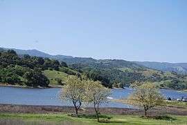 May 2009 | |
| Location | Santa Clara County, California |
| Coordinates | 37°11′08″N 121°46′39″W / 37.18556°N 121.77750°WCoordinates: 37°11′08″N 121°46′39″W / 37.18556°N 121.77750°W[1] |
| Type | Reservoir |
| Primary inflows | Cherry Canyon,[2] Pine Tree Canyon[3] |
| Primary outflows | Arroyo Calero[4] |
| Catchment area | 7.14 sq mi (18.5 km2) |
| Basin countries | United States |
| Managing agency | Santa Clara Valley Water District |
| Max. length | 2.2 mi (3.5 km) |
| Surface area | 349 acres (141 ha) |
| Water volume | 9,934 acre feet (12,253,000 m3) |
| Surface elevation | 476 feet (145 m) |
| References | [5][1][2][3][4][6] |
Calero Reservoir is an artificial lake in the Santa Teresa Hills south of San Jose, California, United States. A 4,471-acre (1,809 ha) county park surrounds the reservoir[7] and provides limited fishing[8] ("catch-and-release"), picnicking, hiking, and horseback riding activities. Although swimming is prohibited,[9] boating, water-skiing and jet-skiing are permitted in the reservoir.[10]
The California Office of Environmental Health Hazard Assessment released a "Do Not Eat" warning regarding eating any fish caught from this reservoir based on the elevated mercury level.[11]
History
The reservoir was formed by the Calero Dam,[12] built in 1935 across Arroyo Calero, which is also known as Calero Creek. Its waters reach the San Francisco Bay by way of Los Alamitos Creek and the Guadalupe River. It is the fourth largest reservoir owned by the Santa Clara Valley Water District.[6]
The reservoir captures and stores winter runoff from the nearby foothills and from Almaden Reservoir. Water recharges groundwater basins and is also provided directly to water treatment plants to be treated and distributed to county residents.[12]
Calero Dam
Calero Dam is an earthen dam 90 feet (27 m) high and 840 feet (260 m) long containing 550,000 cubic yards (420,000 m3) of material. Its crest is 490 feet (150 m) above sea level.[6]
See also
References
- 1 2 "Calero Reservoir". Geographic Names Information System. United States Geological Survey.
- 1 2 "Cherry Canyon". Geographic Names Information System. United States Geological Survey.
- 1 2 "Pine Tree Canyon". Geographic Names Information System. United States Geological Survey.
- 1 2 "Arroyo Calero". Geographic Names Information System. United States Geological Survey.
- ↑ "Listing of Jurisdictional Dams in California" (PDF). California Department of Water Resources. Retrieved July 3, 2017.
- 1 2 3 "Santa Clara Valley Water District: List of Reservoirs". Retrieved 2017-07-03.
- ↑ "Santa Clara County Parks: Calero Reservoir". County of Santa Clara. Retrieved 2017-07-03.
- ↑
"Santa Clara County Parks: Fishing Guidelines". County of Santa Clara. Retrieved 2017-07-02.
Mercury has been found to accumulate in Almaden, Calero, Guadalupe, Anderson and Stevens Creek Reservoirs at levels that make the fish unsafe to eat.
- ↑
"Santa Clara Valley Water District: Recreation Restrictions". Retrieved 2017-07-04.
Swimming at Almaden, Coyote, Anderson and Calero reservoirs is prohibited by the state Department of Health to protect the drinking water supply from potential bacteriological contamination.
- ↑
"Santa Clara County Parks: Boating Guidelines". County of Santa Clara. Retrieved 2017-07-03.
Boating is permitted from 8am to ½ hour before sunset in the following reservoirs: Calero, Coyote Lake, Anderson, Stevens Creek and Lexington.
- ↑ Monserrat, Laurie (2015-03-11). "Calero Reservoir". OEHHA. Retrieved 2018-06-11.
- 1 2
"Santa Clara Valley Water District: Calero Dam and Reservoir". Retrieved 2017-07-03.
Calero Reservoir provides water directly to drinking water treatment plants, which treat and test it for safety. The district then distributes the water to water retailers to sell to the county’s 1.8 million residents. Calero also captures and stores winter runoff to recharge groundwater basins, helps store water from the nearby Almaden Reservoir watershed and accepts imported water.