Oceanside, California
| Oceanside, California | |||
|---|---|---|---|
| City | |||
| City of Oceanside | |||
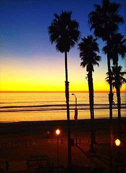 Oceanside's Tyson St. Park beach | |||
| |||
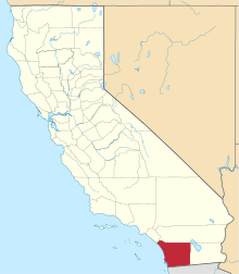
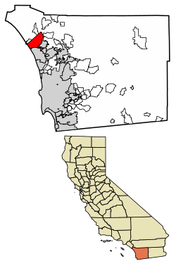 Location of Oceanside within San Diego County, California | |||
 Oceanside, California Location in the United States | |||
| Coordinates: 33°12′42″N 117°19′33″W / 33.21167°N 117.32583°WCoordinates: 33°12′42″N 117°19′33″W / 33.21167°N 117.32583°W | |||
| Country |
| ||
| State |
| ||
| County |
| ||
| Incorporated | July 3, 1888[1] | ||
| Government | |||
| • Type | Council-manager[2] | ||
| • City council[3] |
Mayor Peter Weiss Deputy Mayor Chuck Lowery Jerome M. Kern Esther C. Sanchez Jack Feller | ||
| • City treasurer | Dr. Rafe Edward Trickey, Jr.[4] | ||
| • City clerk | Zack Beck[5] | ||
| Area[6] | |||
| • Total | 42.18 sq mi (109.23 km2) | ||
| • Land | 41.25 sq mi (106.84 km2) | ||
| • Water | 0.92 sq mi (2.39 km2) 2.23% | ||
| Elevation[7] | 66 ft (20 m) | ||
| Population (2010)[8] | |||
| • Total | 167,086 | ||
| • Estimate (2016)[9] | 175,464 | ||
| • Rank |
3rd in San Diego County 26th in California | ||
| • Density | 4,253.47/sq mi (1,642.28/km2) | ||
| Time zone | UTC−8 (Pacific) | ||
| • Summer (DST) | UTC−7 (PDT) | ||
| ZIP Codes | 92049, 92051, 92052, 92054, 92056–92058 | ||
| Area codes | 442/760 | ||
| FIPS code | 06-53322 | ||
| GNIS feature IDs | 1652761, 2411301 | ||
| City flower | Crimson Lake Bougainvillea | ||
| Primary Airport |
John Wayne International Airport (SNA) San Diego International Airport (SAN) | ||
| Interstates |
| ||
| State Routes |
| ||
| Light Rail |
| ||
| Commuter Rail |
| ||
| Website |
www | ||


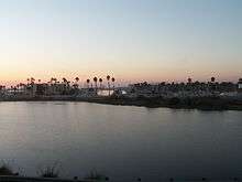
Oceanside is a coastal city located on California's South Coast. It is the third-largest city in San Diego County, California. The city had a population of 167,086 at the 2010 census. Together with Carlsbad and Vista, it forms a tri-city area. Oceanside is located just south of Marine Corps Base Camp Pendleton.[10]
History
Originally inhabited by Native Americans, the first European explorers arrived in 1769. Spanish missionaries under Father Junipero Serra founded Mission San Luis Rey de Francia on a former site of a Luiseño Indian village on the banks of the San Luis Rey River. In the early 19th century, the introduction of farming and grazing changed the landscape of what would become Oceanside. The area—like all of California—was under Spanish, then in 1821 under Mexican rule, and then the U.S. in 1848.
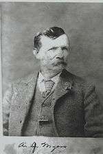
In the late 1850s, Andrew Jackson Myers lived in San Joaquin County. A native of LaSalle County, Illinois, he returned in the late 1880s and lived in San Luis Rey. In 1882 Myers moved on the land that was the original town site for Oceanside. A patent for the land was issued in 1883 by the federal government.[11] It was incorporated on July 3, 1888. The city hall as of the early 21st century stands on the former Myers homestead.[11] The town post office contains an oil-on-canvas mural, Air Mail, painted in 1937 by Elsie Seeds. Federally commissioned murals were produced from 1934 to 1943 in the United States through the Section of Painting and Sculpture, later called the Section of Fine Arts, of the Treasury Department.[12]
In the 20th century, Oceanside was a beach town devoted to activities on a 6-mile (9.7 km) stretch of beaches. Residential areas like downtown (built in the 1890s), South Oceanside (built in the 1920s and 1930s), and developments east of Interstate 5 (built after World War II) are preserved and remodeled when these houses are considered to have historical value. Since the establishment of Marine Corps Base Camp Pendleton in 1942, Oceanside has been home to U.S. armed forces personnel, and the wartime industry of WWII and the 1950s had an ammunition manufacturing facility in the city.
In 1970, the Census Bureau reported city's population as 91.0% white, 5.1% black and 1.7% Asian.[13] After 1970, the main focus of Oceanside was suburban development and a choice for newcomers to move into then relatively affordable housing. Oceanside continues to be known for the value and appreciation as a vacation home market.[14]
Geography
Oceanside is at 33°12′42″N 117°19′33″W / 33.21167°N 117.32583°W (33.211566, -117.325701).[15]
According to the United States Census Bureau, the city has a total area of 42.2 square miles (109 km2), of which 41.2 square miles (107 km2) is land and 0.9 square miles (2.3 km2) (2.23%) is water.
Traveling north on Interstate 5, Oceanside is the last city before Orange County. As the crow flies, it is roughly the same distance from Aliso Viejo as it is to downtown San Diego.
Climate
Oceanside experiences a semi-arid climate (Köppen climate classification BSh) that is significantly tempered by maritime winds and the cool currents off the shoreline. The average high temperatures range from 64 °F (18 °C) to 77 °F (23 °C), while the average low temperatures range from 45 °F (7 °C) to 64 °F (18 °C).
| Climate data for Oceanside | |||||||||||||
|---|---|---|---|---|---|---|---|---|---|---|---|---|---|
| Month | Jan | Feb | Mar | Apr | May | Jun | Jul | Aug | Sep | Oct | Nov | Dec | Year |
| Record high °F (°C) | 87 (31) |
90 (32) |
90 (32) |
93 (34) |
89 (32) |
93 (34) |
103 (39) |
94 (34) |
108 (42) |
105 (41) |
100 (38) |
90 (32) |
108 (42) |
| Average high °F (°C) | 62.6 (17) |
61.8 (16.6) |
62.4 (16.9) |
63.2 (17.3) |
64.8 (18.2) |
67.1 (19.5) |
69.8 (21) |
71.4 (21.9) |
70.8 (21.6) |
68.7 (20.4) |
65.8 (18.8) |
62.9 (17.2) |
65.9 (18.9) |
| Average low °F (°C) | 44.6 (7) |
46.3 (7.9) |
48.8 (9.3) |
52.1 (11.2) |
55.9 (13.3) |
60.3 (15.7) |
62.8 (17.1) |
64.4 (18) |
61.8 (16.6) |
56.8 (13.8) |
49.8 (9.9) |
44.8 (7.1) |
54 (12.2) |
| Record low °F (°C) | 20 (−7) |
28 (−2) |
34 (1) |
33 (1) |
38 (3) |
43 (6) |
44 (7) |
47 (8) |
43 (6) |
36 (2) |
29 (−2) |
27 (−3) |
20 (−7) |
| Average precipitation inches (mm) | 2.02 (51.3) |
2.36 (59.9) |
1.50 (38.1) |
0.96 (24.4) |
0.13 (3.3) |
0.10 (2.5) |
0.01 (0.3) |
0.04 (1) |
0.22 (5.6) |
0.64 (16.3) |
0.84 (21.3) |
1.58 (40.1) |
10.4 (264.1) |
| Source: The Weather Channel[16] | |||||||||||||
Demographics
| Historical population | |||
|---|---|---|---|
| Census | Pop. | %± | |
| 1900 | 330 | — | |
| 1910 | 673 | 103.9% | |
| 1920 | 1,161 | 72.5% | |
| 1930 | 3,508 | 202.2% | |
| 1940 | 4,651 | 32.6% | |
| 1950 | 12,881 | 177.0% | |
| 1960 | 24,971 | 93.9% | |
| 1970 | 40,494 | 62.2% | |
| 1980 | 76,698 | 89.4% | |
| 1990 | 128,398 | 67.4% | |
| 2000 | 161,029 | 25.4% | |
| 2010 | 167,086 | 3.8% | |
| Est. 2016 | 175,464 | [9] | 5.0% |
| U.S. Decennial Census[17] | |||
2010
The 2010 United States Census[18] reported that Oceanside had a population of 167,086. The population density was 3,961.8 people per square mile (1,529.7/km²). The racial makeup of Oceanside was 109,020 (65.2%) White, 7,873 (4.7%) African American, 1,385 (0.8%) Native American, 11,081 (6.6%) Asian (3.4% Filipino, 0.7% Japanese, 0.7% Vietnamese, 0.6% Chinese, 0.4% Korean, 0.2% Indian), 2,144 (1.3%) Pacific Islander, 25,886 (15.5%) from other races, and 9,697 (5.8%) from two or more races. Hispanic or Latino of any race were 59,947 persons (35.9%).
The Census reported that 166,150 people (99.4% of the population) lived in households, 802 (0.5%) lived in non-institutionalized group quarters, and 134 (0.1%) were institutionalized.
There were 59,238 households, out of which 20,486 (34.6%) had children under the age of 18 living in them, 30,201 (51.0%) were opposite-sex married couples living together, 6,947 (11.7%) had a female householder with no husband present, 3,111 (5.3%) had a male householder with no wife present. There were 3,504 (5.9%) unmarried opposite-sex partnerships, and 472 (0.8%) same-sex married couples or partnerships. 14,117 households (23.8%) were made up of individuals and 6,161 (10.4%) had someone living alone who was 65 years of age or older. The average household size was 2.80. There were 40,259 families (68.0% of all households); the average family size was 3.32.
The population was spread out with 39,817 people (23.8%) under the age of 18, 19,028 people (11.4%) aged 18 to 24, 45,797 people (27.4%) aged 25 to 44, 40,943 people (24.5%) aged 45 to 64, and 21,501 people (12.9%) who were 65 years of age or older. The median age was 35.2 years. For every 100 females, there were 97.4 males. For every 100 females age 18 and over, there were 95.0 males.
There were 64,435 housing units at an average density of 1,527.8 per square mile (589.9/km²), of which 34,986 (59.1%) were owner-occupied, and 24,252 (40.9%) were occupied by renters. The homeowner vacancy rate was 2.2%; the rental vacancy rate was 6.2%. 97,645 people (58.4% of the population) lived in owner-occupied housing units and 68,505 people (41.0%) lived in rental housing units.
2000
As of the census[19] of 2000, there were 161,029 people, 56,488 households, and 39,259 families residing in the city. The population density was 3,967.2 inhabitants per square mile (1,531.7/km²). There were 59,581 housing units at an average density of 1,467.9 per square mile (566.7/km²). The racial makeup of the city was 66.4% White, 6.3% African American, 5.5% Asian, 1.2% Pacific Islander, 0.4% Native American or Alaskan Native, 0.1% from another race alone, and 3.2% from two or more races. Hispanic or Latino of any race was 30.2%.
In 2000, there were 56,488 households out of which 35.0% had children under the age of 18 living with them, 54.1% were married couples living together, 11.0% had a female householder with no husband present, and 30.5% were non-families. 22.7% of all households were made up of individuals and 10.2% had someone living alone who was 65 years of age or older. The average household size was 2.83 and the average family size was 3.33.
The age distribution of Oceanside in 2000 was as follows: 27.6% under the age of 18, 10.2% from 18 to 24, 31.0% from 25 to 44, 17.6% from 45 to 64, and 13.6% who were 65 years of age or older. The median age was 33 years. For every 100 females, there were 98.0 males. For every 100 females age 18 and over, there were 96.1 males.
The median income for a household in the city was $46,301, and the median income for a family was $52,232. Males had a median income of $34,772 versus $27,962 for females. The per capita income for the city was $20,329. About 8.2% of families and 11.6% of the population were below the poverty line, including 16.2% of those under age 18 and 5.7% of those age 65 or over.
Economy
According to the City's 2009 Comprehensive Annual Financial Report,[20] the top employers in the city are:
| # | Employer | # of Employees |
|---|---|---|
| 1 | Tri-City Medical Center | 1,900 |
| 2 | City of Oceanside | 1,060 |
| 3 | Mira Costa College | 1,270 |
| 4 | Select Staffing | 600 |
| 5 | North County Transit District | 600 |
| 6 | Genentech | 500 |
| 7 | Milagro Ranch | 400 |
| 8 | Ocean's Eleven Casino | 400 |
| 9 | Hydranautics | 300 |
| 10 | Registry Network | 300 |
Oceanside is home to the World's Largest Women's Surf Competition, the Supergirl Pro Jam event is held yearly since 2007.[21] Each Thursday evening, downtown Oceanside hosts the Sunset Market - a gathering of local vendors, hot food and live entertainment.[22]
Attractions
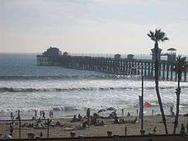
- The Oceanside Pier, first built in 1888 (and now in its sixth incarnation), is one of the longest wooden piers on the western United States coastline at 1,942 feet (592 m).[23]
- The historic district of Mount Ecclesia, home to the Rosicrucian Fellowship, is noted for its singular architecture and the preservation of nature grounds and gardens, offering a unique meditative walking experience.
- The California Surf Museum is located in downtown Oceanside.
- The Oceanside Transit Center provides train services on Amtrak, Metrolink, Coaster, and Sprinter.
- Founded in 2006, the PMCU O'side Turkey Trot hosts approximately 10,000 runners and walkers from 46 states and 8 countries. It is the 8th largest Turkey Trot in the country, according to Running in the USA.
- Since 2006, Oceanside has played host to the official start of the annual 3000 mile bicycle race, Race Across America, which is usually held during the second week of June. It is considered the world's toughest sporting event by many experts.[24]
- Oceanside hosts The Beach Soccer Championships The Beach Soccer Championships since 2007, the festival is the largest on the west coast and takes place weekend after mother's day in May. The event has a PRO side to the event called The Beach Soccer USA Cup and it is considered to host the toughest competition of its kind in the USA.
- The famous house in the film, Top Gun, where Kelly McGillis and Tom Cruise shot a romantic scene.
Government
Municipal government
The City operates under the Council-Manager form of government. The City of Oceanside is a full-service City. They provide their own police and fire safety, library, water and sewer services. In addition, the City has a municipal airport, a small craft harbor, one of the longest wooden piers in the west, golf courses, swimming pools, numerous parks, community centers, and extensive palm-lined beaches.
City of Oceanside Comprehensive Annual Financial Report for the year ended June 20, 2017: https://www.ci.oceanside.ca.us/civicax/filebank/blobdload.aspx?blobid=46256
State and federal representation
In the California State Legislature, Oceanside is in the 36th Senate District, represented by Republican Patricia Bates, and in the 76th Assembly District, represented by Republican Rocky Chávez.[25]
In the United States House of Representatives, Oceanside is in California's 49th congressional district, represented by Republican Darrell Issa.[26]
Education
Residents of Oceanside may attend schools in the Oceanside Unified School District, Vista Unified School District, Bonsall Union School District, Carlsbad Unified School District, Fallbrook Union High School District, or Fallbrook Union Elementary School District, depending on their actual address. The Oceanside Unified School District provides instrumental music programs in grades 4-12.
The Oceanside Unified School District has two comprehensive high schools, El Camino High School off Rancho Del Oro and Oceanside High School off Mission Avenue. High school students are also served by Ocean Shores Continuation High School and Clair Burgener Academy. OUSD has 24 schools plus three charter schools, including the School of Business and Technology, and two brand new schools, Louise Foussat Elementary School and Cesar Chavez Middle School, that opened in the Fall of 2007. Cesar Chavez Middle School, which is on the corner of Frazee and Oleander, will be built on a 14 acres (5.7 ha), house 11 building totaling 84,000 square feet (7,800 m2) and will serve 1,000 6th–8th grade students.
The other school, Louise Foussat Elementary School, located on Pala Road, is built on 12.6 acres (5.1 ha) of land with 35 classrooms totaling 54, 490 square feet (46 m2) and can accommodate 800 students.
Sister cities
- Ensenada, Mexico
- Kisarazu, Chiba, Japan[27]
- Fuji, Shizuoka, Japan
- A'ana, Samoa
Notable people
- Bobbi DePorter, founder of the internationally acclaimed SuperCamp program, and President of the Quantum Learning Network.[28]
- Mark Dice, author, media analyst.
- Phil Edwards, surfer.[29]
- Mickey Finn, inventor of weapons systems.
- Francis French, author.
- Bill Goldberg, retired professional wrestler, football player, and actor.[30]
- Michael C. Gross, retired magazine director, National Lampoon, Heavy Metal, and film producer, Ghostbusters, Beethoven.
- Anissa Jones, former child star of TV's sitcom Family Affair.
- Thomas Keller, restaurateur.
- David B. Kurtz, second mayor of San Diego (1851–52), lived in Oceanside.
- Frank Lasee, Wisconsin politician.
- Christopher Lloyd, actor, Taxi, Back to the Future films.
- Rear Admiral Dick Lyon, one of the first 10 Navy Seals (formerly called "Scouts and Raiders"), and the first Special Warfare Officer to attain that rank. He served as mayor of the city in the 1990s.[31]
- Barbara Mandrell, country singer, former Miss Oceanside.[32] Graduated from Oceanside High School in 1967.[33]
- Elana Meyers, 2014 Olympic medalist (bobsleigh).[34]
- Jordan Pundik, of pop band New Found Glory.
- Denise Richards, actress who starred in Starship Troopers, Wild Things and the James Bond film The World Is Not Enough. Graduated from El Camino High School in 1989.[35]
- Garth Smith - pianist/musician/composer.
- Chris Thile, virtuoso mandolinist of Nickel Creek; born in Oceanside.[36]
- Evan Tanner, former UFC middleweight champion.
- Brandon Vera, UFC mixed martial artist.
- Victor Villaseñor, acclaimed Mexican-American writer.
- Brian Kibler, Magic: The Gathering Hall of Famer and game designer.
Major League Baseball players
- Heath Bell, retired pitcher for the San Diego Padres.
- Thad Bosley, outfielder for the California Angels, Chicago White Sox, Milwaukee Brewers, Seattle Mariners, Chicago Cubs, Kansas City Royals, and the Texas Rangers.
- Trevor Cahill, pitcher for the Chicago Cubs.
- Chris Chambliss, first baseman who played from 1971 to 1988 for the Cleveland Indians, New York Yankees and Atlanta Braves, graduated from Oceanside High School in 1966.
- Gary Thomasson, outfielder and first baseman who played from 1972 to 1980 for the San Francisco Giants, Oakland Athletics, New York Yankees and Los Angeles Dodgers, graduated from Oceanside High School in 1969, part of the Yankees' 1978 World Series-winning team.
National Football League players
- Justin Blackmon, went to Oklahoma State University and was drafted 5th overall by the Jacksonville Jaguars.
- Sam Brenner, plays for the Denver Broncos. Graduated from Oceanside High School in 2008.
- Michael Booker, graduated from El Camino High School in 1993, went to the University of Nebraska and was drafted 11th overall by the Atlanta Falcons.
- Willie James Buchanon, played for the Green Bay Packers and San Diego Chargers. Graduated from Oceanside High School in 1968.
- D. J. Clark, played for the Green Bay Packers.[37]
- J.C. Pearson, played for the Kansas City Chiefs and Minnesota Vikings.
- Joe Salave'a, plays for the Washington Redskins.[38]
- Junior Seau, played for the San Diego Chargers, Miami Dolphins, and New England Patriots, and made 12 Pro Bowls[39]
- Ken Stills, played for the Green Bay Packers and Minnesota Vikings.[40]
- Toussaint Tyler, played running back for the New Orleans Saints for two seasons.[41]
- Bryant Westbrook, played for the Detroit Lions, Dallas Cowboys and Green Bay Packers. Graduated from El Camino High School in 1993.
- Dokie Williams, played for the Los Angeles Raiders for five seasons.
References
- ↑ "California Cities by Incorporation Date". California Association of Local Agency Formation Commissions. Archived from the original (Word) on October 17, 2013. Retrieved August 25, 2014.
- ↑ "City At A Glance". City of Oceanside, California. Retrieved January 28, 2015.
- ↑ "City Council". City of Oceanside, CA. Retrieved December 30, 2014.
- ↑ "City Treasurer". City of Oceanside, CA. Retrieved December 18, 2017.
- ↑ "City Clerk". City of Oceanside, CA. Retrieved January 14, 2015.
- ↑ "2016 U.S. Gazetteer Files". United States Census Bureau. Retrieved Jun 28, 2017.
- ↑ "Oceanside". Geographic Names Information System. United States Geological Survey. Retrieved January 3, 2015.
- ↑ "Oceanside (city) QuickFacts". United States Census Bureau. Archived from the original on January 2, 2012. Retrieved March 11, 2015.
- 1 2 "Population and Housing Unit Estimates". Retrieved June 9, 2017.
- ↑ Marine Corps Base Archived December 8, 2006, at the Wayback Machine. Camp Pendleton
- 1 2 "Image:Oceanside plaque". Retrieved July 17, 2006.
- ↑ Arnesen, Eric (2007). Encyclopedia of U.S. Labor and Working-Class History. 1. New York: Routledge. p. 1540. ISBN 9780415968263.
- ↑ "Race and Hispanic Origin for Selected Cities and Other Places: Earliest Census to 1990". U.S. Census Bureau.
- ↑ Fletcher, June (June 13, 2005). "The Hottest Vacation-Home Markets: Second homes are sizzling; We tell you where -- and why". The Wall Street Journal. p. R1.
- ↑ "US Gazetteer files: 2010, 2000, and 1990". United States Census Bureau. 2011-02-12. Retrieved 2011-04-23.
- ↑ . Intellicast https://weather.com/weather/monthly/l/92054:4:US. Retrieved December 12, 2017. Missing or empty
|title=(help) - ↑ "Census of Population and Housing". Census.gov. Retrieved June 4, 2015.
- ↑ "2010 Census Interactive Population Search: CA - Oceanside city". U.S. Census Bureau. Retrieved July 12, 2014.
- ↑ "American FactFinder". United States Census Bureau. Retrieved 2008-01-31.
- ↑ City of Oceanside CAFR Retrieved August 13, 2009
- ↑ "Welcome". Super Girl Jam.
- ↑ "Sunset Market". Main Street Oceanside.
- ↑ "Oceanside Pier - Visit Oceanside".
- ↑ "RebelMouse vs. WordPress VIP". May 10, 2017.
- ↑ "Statewide Database". UC Regents. Retrieved November 30, 2014.
- ↑ "California's 49th Congressional District - Representatives & District Map". Civic Impulse, LLC.
- ↑ "US-Japan Sister Cities by State". Asia Matters for America. Honolulu, HI: East-West Center. Retrieved 20 November 2015.
- ↑ "Q&A: Bobbi DePorter; founder of Quantum Learning Network". The San Diego Union-Tribune. Retrieved May 10, 2009.
- ↑ Ahrens, Chris (September 17, 1992). "Surfing the Wave of Tradition". Los Angeles Times. Retrieved February 28, 2012.
- ↑ The Hebrew Hulk Archived October 3, 2009, at the Wayback Machine.
- ↑ "Elected officials are skilled — at getting elected". North Country Times. Archived from the original on December 2, 2008. Retrieved May 10, 2009.
- ↑ Sleeman, Elizabeth (May 24, 2018). "The International Who's Who of Women 2002". Psychology Press – via Google Books.
- ↑ "Barbara Mandrell". www.nndb.com.
- ↑ "GWsports.com Elana Meyers Bio :: George Washington University Official Athletic Site :: George Washington University Official Athletic Site :: Softball".
- ↑ "Denis Richards Pictures".
- ↑ "Edgar Meyer and Chris Thile".
- ↑ "D.J. Clark". NFL.com.
- ↑ "Joe Salave'a".
- ↑ "Former Charger Junior Seau Commits Suicide: Cops". NBC San Diego.com. NBC. Retrieved May 2, 2012.
- ↑ "Ken Stills NFL Football Statistics". Pro-Football-Reference.com. September 6, 1963. Retrieved June 4, 2013.
- ↑ Toussaint Tyler NFL & AFL Football Statistics". Pro-Football Reference. Retrieved February 10, 2010.
External links
| Wikivoyage has a travel guide for Oceanside. |
| Counties | ||
|---|---|---|
| Major city | ||
| Cities 100k - 250k | ||
| Cities and towns 20k - 99k | ||
| CDPs 20k+ | ||
| Bodies of water | ||
| Regions | ||
| Parks and Monuments | ||