Saint-Vincent-d'Olargues
| Saint-Vincent-d'Olargues | ||
|---|---|---|
| Commune | ||
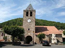 The church of Saint-Vincent-d'Olargues | ||
| ||
 Saint-Vincent-d'Olargues Location within Occitanie region  Saint-Vincent-d'Olargues | ||
| Coordinates: 43°33′41″N 2°52′48″E / 43.5614°N 2.88°ECoordinates: 43°33′41″N 2°52′48″E / 43.5614°N 2.88°E | ||
| Country | France | |
| Region | Occitanie | |
| Department | Hérault | |
| Arrondissement | Béziers | |
| Canton | Saint-Pons-de-Thomières | |
| Intercommunality | Orb et Jaur | |
| Government | ||
| • Mayor (2008–2014) | Jacques Lepape | |
| Area1 | 15.84 km2 (6.12 sq mi) | |
| Population (2008)2 | 328 | |
| • Density | 21/km2 (54/sq mi) | |
| Time zone | UTC+1 (CET) | |
| • Summer (DST) | UTC+2 (CEST) | |
| INSEE/Postal code | 34291 /34390 | |
| Elevation |
180–1,085 m (591–3,560 ft) (avg. 280 m or 920 ft) | |
|
1 French Land Register data, which excludes lakes, ponds, glaciers > 1 km2 (0.386 sq mi or 247 acres) and river estuaries. 2 Population without double counting: residents of multiple communes (e.g., students and military personnel) only counted once. | ||
.svg.png)
Saint-Vincent-d'Olargues is a commune in the Hérault department in the Occitanie region in southern France.
Population
| Historical population | ||
|---|---|---|
| Year | Pop. | ±% |
| 1962 | 306 | — |
| 1968 | 372 | +21.6% |
| 1975 | 340 | −8.6% |
| 1982 | 335 | −1.5% |
| 1990 | 301 | −10.1% |
| 1999 | 323 | +7.3% |
| 2008 | 328 | +1.5% |
See also
References
| Wikimedia Commons has media related to Saint-Vincent-d'Olargues. |
This article is issued from
Wikipedia.
The text is licensed under Creative Commons - Attribution - Sharealike.
Additional terms may apply for the media files.