Penparcau
Penparcau
| |
|---|---|
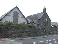 St Anne's Church, Penparcau | |
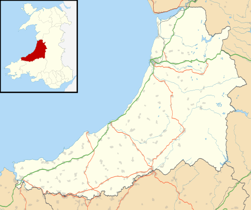 Penparcau Penparcau shown within Ceredigion | |
| Population | 3,122 |
| OS grid reference | SN591801 |
| Principal area | |
| Ceremonial county | |
| Country | Wales |
| Sovereign state | United Kingdom |
| Post town | ABERYSTWYTH |
| Postcode district | SY23 |
| Dialling code | 01970 |
| Police | Dyfed-Powys |
| Fire | Mid and West Wales |
| Ambulance | Welsh |
| EU Parliament | Wales |
| UK Parliament | |
| Welsh Assembly | |
Penparcau is a village in Ceredigion near to the town of Aberystwyth, Wales, it is situated to the south of Aberystwyth. It is the largest village and electoral ward in Ceredigion. The village has the largest number of Welsh language speakers in the Aberystwyth Town area (1095) [1]
Location and amenities
The original village was a small hamlet, one mile east of Aberystwyth town centre, but the building of extensive Art Deco style semi-detached social housing from the 1920s on transformed it. It lies in the shadow of the Celtic Iron Age hill fort of Pen Dinas, and between the River Ystwyth and the River Rheidol. Penparcau is part of the only UNESCO Biosphere reserve in Wales, the Dyfi Biosphere.[2]
There is an Anglican church named after the Saint Ann, a Roman Catholic church named after the Welsh Martyrs, two Methodist chapels and a Quaker meeting house. The recently closed Tollgate pub was named after the original tollgate[3] that stood on the old toll road at the top of Penparcau and is now in St Fagans National History Museum near Cardiff.
Penparcau has its own woodland, Coed Geufron[4] run by the Woodland Trust and its own police station.[5] Other amenities include a post office, two small supermarkets, a garage, holiday park and hotel and until recently two fish and chip shops, one of which has a reputation as one of the best in the area. Until late 2007, it also had its own travel agent.
Penparcau once played a part in the Transition Town movement in Wales[6] when it hosted an "Alternative Energy and Transport Festival" in Neuadd Goffa, attended by the local MP and mayor. At the bottom of the valley, just below Penparcau, is a new Welsh Assembly Government office building, designed to house more than 550 staff.[7][8]
Penparcau Community Forum was set up in November 2012 (although a Forum existed prior to the Communities First project) to encourage residents to air their views on matters that affect them and to organise activities that would bring back the community spirit that many feel has been lost in recent times. On 31 March 2013, the Forum took over the Communities First office in the village, after Communities First ceased to exist in rural wales. It is self funding and run by a coordinator and enthusiastic directors/volunteers. Potential volunteers or interested parties are encouraged to contact the office on 01970 611099. The Forum has extended the community centre in Southgate to include substantial facilities including a café.
History
People have lived in and around Penparcau for over two thousand years. The Iron Age hillfort is believed to have been occupied for some 300 years up to and including the 1st century BC. Pen Dinas is the largest Iron Age hillfort in Ceredigion. Estimated to have been first built around 400 BC, the outline of the ancient ramparts is still evident.
Mesolithic
There is evidence that during the Mesolithic Age the area of Tan-y-Bwlch at the foot of Pen Dinas (Penparcau) was used as a flint knapping floor for hunter-gatherers making weapons from flint that was deposited as the ice retreated.[9]
Submerged Forest
To the south of Tan-y-Bwlch beach lies an area where during low tides a submerged forest can be clearly seen. This is thought to be between 4000 – 6000 years old. A record relating to the submerged forest can be found made by the Royal Commission on the Royal Commission on the Ancient and Historical Monuments of Wales [10][11]
Bronze and Iron Ages
The remains of a Celtic fortress on Pen Dinas (or more correctly 'Dinas Maelor' home of the mythical Celtic giant king Maelor Gawr), a hill in Penparcau overlooking Aberystwyth, indicates that the site was inhabited before 700 BC.[12][13] On a hill south of the present town, across the River Ystwyth, are the remains of a medieval ringfort believed to be the castle from which Princess Nest was abducted. This rare survival is now on private land and can only be accessed by arrangement.[14] A Bronze Age standing stone is also referenced as being in Penparcau in the Ceredigion County History (Volume 1)[15] and the Dyfed Archaeological records.[16]
Modern History
A distinctive memorial to the Duke of Wellington in the shape of an upturned cannon was built on the hilltop in 1852. The hilltop comprises a twin summit system and the mounded defences divide into three systems. Archaeological excavations in the 1930s demonstrated at least four phases to the defences.[17][18] Pen Dinas is now more popular as a tourist attraction for walkers and used in a more sedate manner for paragliding.[19]
Penparcau (pronounced in the local dialect as 'pen parky' or 'penpark'e with an emphasis on the e, as in the dialectical pronunciation of 'au' in North Ceredigion, where 'pethau' becomes 'pethe'(in Welsh)) in 1841 was spelled Penparke, Penparciau,[20] Penparkie or even Pen Y Parciau[21] (on the 1890 OS map) and stretched on both sides of the turnpike road from Trefechan to Southgate. The population of the hamlet was 239, most of whom were workers in agriculture and related rural industries. There were three agricultural labourers and only one farmer; the next most important occupation was that of stonemason of whom there were eight. There were three shoemakers, two tailors and two shipwrights as well as the following: rope-maker, joiner, tanner, carpenter, gardener, sawyer, wheelwright, weaver and saddler.
In the 18th century, smuggling was a key part of the economy, with tea, salt, rum and tobacco being some of the things smuggled into the local area. There are records in the national archive showing an extensive smuggling ring run by the Powell and neighbouring Stedman families. The smuggled goods were bought into Penparcau to avoid the excise men stationed in Aberystwyth.
There is also interesting domestic architecture that can be assigned to Richard Emrys Bonsall[22] such as the Ebeneser Chapel, still in use today. The plans for many of these buildings can be found at the National Library of Wales.
A famous feature that existed in Penparcau was the toll house. It was built in 1771 and stood at the southern junction of Penparcau (hence the name Southgate). It was built of local slate stone and was roofed with Pembrokeshire slates. David Jones of Dihewyd was appointed as the first gatekeeper in November 1771, and the first tolls were charged on 23 March 1772. The building contains just one room, one end being used for the collection of tolls. A single fireplace at the opposite end of the house was used for heating and cooking. Toll houses were very unpopular with people in rural areas who had to pay to travel along the roads. At St Fagans the house has been furnished in the style of 1843, the period of the Rebecca Riots when many tollgates were destroyed in Wales. Turnpike Trusts were eventually abolished in 1864 with county councils taking over responsibility for building and maintaining the roads but the Penparcau toll house remained a residence until the 1960s.
Culture
The United Kingdom Census 2001 reported that over 40% of the residents of Penparcau spoke Welsh and used Welsh daily, larger than any other individual census zone within that area, when compared to the other census data sets.[23]
Notable Residents
The area has a long literary tradition. The famous bard/academic writer D. Gwenallt Jones (David James Jones) lived in the area.[24] More recently another resident, Ifan Morgan Jones,[25] won the Daniel Owen Memorial Prize for his novel at the National Eisteddfod of Wales in 2008. Other notable residents have also included the Bishop of Bangor the Right Reverend Andrew John and Gwyn Jenkins the author of a Visual record of life in the Welsh countryside. Other notable residents have been the actress Jane Stanness, who was "...brought up in Aberystwyth, living first in Penparcau"[26] [27]Mike Jenkins author, poet and father of Bethan Jenkins AM who was brought up in the village as a boy, the author Suzy Davies (now residing in the US), who mentions the village in her novel Johari's Window and Eurfyl ap Gwilym a Welsh economist originally from Penparcau, a prominent member of Plaid Cymru, and Deputy Chairman of the Principality Building Society who famously clashed with BBC Newsnight's Jeremy Paxman.
Myth, folklore and legend
One of the more unusual residents is the headless dog of Penparcau. The myth tells of how a giant, going to his father's rescue, rode at such a rate that his dog could not keep up with him and its head came off in the leash. The dog now roams, mournfully crying and looking for its long-lost owner.[28] Other local stories relate to the discovery of ancient gold in Penparcau, thought to have once belonged to the druids (Celts) living around the Penparcau and Pen Dinas area. There may be some truth to this as early coin hoards have been found, that suggests some of the earliest religious activity in Wales took place on this site.[29] It has also been theorised that the original inhabitants were the same people that made the Banc Ceilliau sun-disc[30] in nearby Cwmystwyth. There are also many stories relating to the pirates that used this part of the coastline such as Bartholomew ‘Black Bart’ Roberts the Pirate.
During one winter in the late 19th century, villagers woke to find mysterious footprints in the fresh snow. It soon became apparent that these had not been made by any human as they were hoofprints made by a creature who walked on two legs and not four. Villagers followed these hoofprints and found that the creature had walked through fields, roads and even managed to walk over walls and roofs in one uninterrupted path. It was believed that the Devil had walked through Penparcau that snowy night and has never been seen back since.
Governance
Aberystwyth-Penparcau is the largest electoral division in Ceredigion and elects two county councillors.
Penparcau is also the name of the village which covers a portion of the electoral division consisting of the areas of Southgate and Caeffynnon.
Five town councillors represent the area as part of the Aberystwyth Town Council, one of the 51 town and community councils in Ceredigion and consists of 19 town councillors elected in five wards. The last elections were held in May 2012.
Penparcau is governed by Ceredigion County Council and Aberystwyth itself elects six of the 42 councillors in five separate wards (Bronglais, Central, North, Rheidol and Penparcau - the Penparcau ward elects two of these). The current two county councillors, elected in May 2012 are Plaid Cymru.
Penparcau has five Welsh Assembly members, one of whom is elected as a constituency AM for Ceredigion, Elin Jones and four who are elected on the regional list for Mid and West Wales.
The village is also within the Ceredigion constituency for elections to the House of Commons. The current MP is Ben Lake for Plaid Cymru.
Wildlife
The Penparcau electoral ward stretches from Tan y Bwlch beach to the river Rheidol. Within this area are two SSSIs (Sites of Special Scientific Interest) and the Pen Dinas and Tan y Bwlch Local Nature Reserve (LNR).
Coastal Path
A section of the Wales Coast Path runs over Tan y Bwlch beach.
References
- ↑ https://www.ceredigion.gov.uk/media/3229/ceredigionlsblanguagestrategy2015-20.pdf
- ↑ "Archived copy" (PDF). Archived from the original (PDF) on 2011-10-07. Retrieved 2009-06-22.
- ↑ Horsfall-Turner, E.R (1906) Walks and Wanderings in County Cardigan Yorks: Thomas Harrison & Sons.
- ↑ "Coed Geufron — a Woodland Trust wood". Wt-woods.org.uk. 2010-01-08. Archived from the original on 2009-01-06. Retrieved 2010-07-15.
- ↑ "Dyfed Powys Police | Penparcau and Llanbadarn Policing Team". Dyfed-powys.police.uk. Archived from the original on 2010-04-30. Retrieved 2010-07-15.
- ↑ Archived June 9, 2008, at the Wayback Machine.
- ↑ "UK | Wales | Assembly jobs move to mid and north". BBC News. 2005-02-23. Retrieved 2010-07-15.
- ↑ "UK | Wales | Mid Wales | Assembly base could open in 2008". BBC News. 2007-01-03. Retrieved 2010-07-15.
- ↑ Houlder, C. H., "The Stone Age!, in J. L. Davies and D. P. Kirkby, Cardiganshire County History, I, (1994), pp. 107–123
- ↑ TAN Y BWLCH SUBMERGED FOREST http://www.coflein.gov.uk/en/site/421874/details/tanybwlch-submerged-forest
- ↑ Evans, J.G., Limbrey, S. and Cleere, H. (eds) 1975. The effect of man on the landscape: the Highland Zone. CBA Research Report No 11 (1975)
- ↑ Briggs, C. S., "The Bronze Age", in J. L. Davies and D. P. Kirkby, Cardiganshire County History, I, (1994), p. 216, : appendix V, : no. 15
- ↑ Browne, D and Driver, T., Bryngaer Pendinas Hill Fort, A Prehistoric Fortress at Aberystwyth, (2001)
- ↑ Houlder, C.H., (1957), "Recent Excavations in Old Aberystwyth", Ceredigion, III, no. 2, pp. 114–117
- ↑ Briggs, C S, 1994 ‘The Bronze Age’, in J L Davies and D P Kirby (Eds.), Cardigan County History, Volume 1, From the Earliest of Times to the Coming of the Normans, 124-218
- ↑ Bronze Age Standing Stone (Cae Maen) http://cofiadurcahcymru.org.uk/arch/query/page.php?watprn=DAT4844
- ↑ "Aerial photograph of Pen Dinas Iron Age hillfort, Aberystwyth, 1989". Gtj.org.uk. Archived from the original on 2007-10-10. Retrieved 2010-07-15.
- ↑ "Aerial photograph of Pen Dinas Iron Age hillfort, Aberystwyth, 1989". Gtj.org.uk. Archived from the original on 2007-09-27. Retrieved 2010-07-15.
- ↑ "Pen Dinas (Open) (Mid-Wales Hang Gliding and Paragliding Club)". Flymidwales.org.uk. Retrieved 2010-07-15.
- ↑ Archived June 21, 2006, at the Wayback Machine.
- ↑ "Maps > Ordnance Survey 1:10,560 - Epoch 1 > Wales — Cardiganshire > 006/SW | British History Online". British-history.ac.uk. 2003-06-22. Retrieved 2010-07-15.
- ↑ "The Architecture of Wales — Architectural Drawings in The National Library of Wales". Llgc.org.uk. Retrieved 2010-07-15.
- ↑ Neighbourhood Statistics. "Check Browser Settings". Neighbourhood.statistics.gov.uk. Archived from the original on 2011-06-04. Retrieved 2010-07-15.
- ↑ "The National Library of Wales :: Dictionary of Welsh Biography". Yba.llgc.org.uk. Retrieved 2010-07-15.
- ↑ "Welcome | The National Eisteddfod of Wales". Eisteddfod.org.uk. Archived from the original on 2008-11-23. Retrieved 2010-07-15.
- ↑ http://www.cambrian-news.co.uk/article.cfm?id=118971
- ↑ https://www.imdb.com/name/nm1920106/
- ↑ Jones, T. Gwynn (1930) Welsh Folklore and Folk-Custom London: Methuen & Co Ltd.
- ↑ "Archived copy". Archived from the original on 2007-07-06. Retrieved 2007-11-03.
- ↑ "Archived copy". Archived from the original on 2007-06-03. Retrieved 2007-11-03.
External links
- 1890 Map of Penparcau
- Penparcau Community Site
- Penparcau Community Forum Site
- Archives of the Royal Commission on the Ancient and Historical Monuments of Wales 1
- Archives of the Royal Commission on the Ancient and Historical Monuments of Wales 2
- Archives of the Royal Commission on the Ancient and Historical Monuments of Wales 3
- www.geograph.co.uk : photos of Penparcau and surrounding area
- Penparcau
- A map of the Penparcau ward