River Clun, Shropshire
| River Clun | |
| River | |
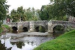 The river flowing through the town of Clun, in which the historic packhorse bridge is still the only vehicle-carrying bridge. | |
| Name origin: Colun (British)[1] | |
| Countries | England, United Kingdom |
|---|---|
| Region | West Midlands |
| County | Shropshire, Herefordshire |
| Tributaries | |
| - left | River Unk, River Kemp |
| - right | River Redlake |
| Cities | Newcastle, Clun, Clunton, Clungunford |
| Landmarks | Clun Bridge, Broadward Bridge |
| Source | |
| - location | Anchor, Shropshire |
| Mouth | Confluence with River Teme |
| - location | Leintwardine, Herefordshire |
| - elevation | 119 m (390 ft) |
| - coordinates | 52°21′35″N 2°52′43″W / 52.3598°N 2.8785°WCoordinates: 52°21′35″N 2°52′43″W / 52.3598°N 2.8785°W |
| Length | 45.84[2][3][4] km (28 mi) |
| Basin | 300[5] km2 (116 sq mi) |
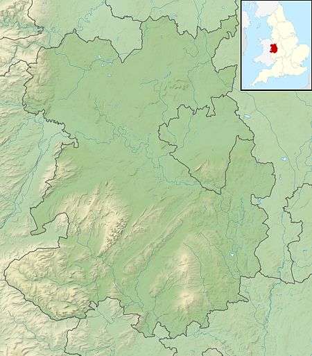
The River Clun is a river mostly in Shropshire, England which runs through the small town of Clun, as well as through or near a number of other villages situated along its valley. It discharges into the River Teme at Leintwardine, Herefordshire. The Clun Valley is very rural and is part of the Shropshire Hills AONB (Area of Outstanding Natural Beauty).[6]
Course
The source of the River Clun is near the hamlet of Anchor (in the marshy area by the public house there), very close to the Welsh border.[7] It then flows east along the southern edge of Clun Forest[8] until the Aston on Clun area (it does not actually run through the village), where it then flows roughly in a southern direction — the river flows around the north end of Clunbury Hill.[9] After this change in direction it enters the lower valley — the valley widens and has a flatter floor (an extensive flood plain).[10]
The Folly Brook joins the Clun at Newcastle, then the small River Unk flows into the Clun near Clun Castle, whilst the small River Kemp flows into the river at Oaker near Aston. Near the end of the river's course, the River Redlake joins at Jay.[9]
The river flows into Herefordshire after passing Broadward (it is a Site of Special Scientific Interest for a stretch south of Broadward Bridge) and soon after enters the River Teme.[11]
Features
The river gives its name to many places in the area, including Clun itself and the villages of Newcastle-on-Clun, Clunton, Clunbury, Aston on Clun, and Clungunford (in order as you head downstream).[1] In Clun, the historic Clun Bridge still takes the A488 road over the river.[12] A number of other historic crossings — bridges and fords — exist over the river, including Broadward Bridge. [13]
Ecology
The River Clun has been noted as ideal habitat for otters, salmon, white-clawed crayfish, bullhead, grayling and brook lamprey.[5] However, the river is mostly noted for its population of the freshwater pearl mussel which number between one and five thousand.[14] The river and one of its tributaries, the Unk, have been subject to pollution and sediment build up, which affects the natural habitat of the mussel.[5] The catchment area of the river is mostly rural and consists of beef and lamb farming with potato and maize growing.[15]
The Clun is only one of eleven watercourses in England that is home to the mussel[14] and one of three English rivers that has been designated as a European Special Area of Conservation.[16]
See also
References
- 1 2 Ekwall, Eilert (1960). The concise Oxford dictionary of English place-names (4 ed.). Oxford: Clarendon Press. p. 113. ISBN 0-19-869103-3.
- ↑ "Clun - source to conf Folly Bk". environment.data.gov.uk. Environment Agency. Retrieved 10 April 2017.
- ↑ "Clun - conf Folly Bk to conf R Unk". environment.data.gov.uk. Environment Agency. Retrieved 10 April 2017.
- ↑ "Clun - conf R Unk to conf R Teme". environment.data.gov.uk. Environment Agency. Retrieved 10 April 2017.
- 1 2 3 "River Clun SSSI/SAC" (PDF). shropshirehillsaonb.co.uk. Atkins. 29 March 2012. p. 5. Retrieved 10 April 2017.
- ↑ "Map Shropshire Hills AONB". www.shropshirehillsaonb.co.uk. Retrieved 10 April 2017.
- ↑ "214" (Map). Llanidloes & Newtown. 1:50,000. Explorer. Ordnance Survey. 2015. ISBN 9780319244074.
- ↑ "216" (Map). Welshpool & Montgomery. 1:50,000. Explorer. Ordnance Survey. 2015. ISBN 9780319244098.
- 1 2 "201" (Map). Knighton & Presteigne. 1:50,000. Explorer. Ordnance Survey. 2015. ISBN 9780319243947.
- ↑ "River Clun SSSI/SAC" (PDF). shropshirehillsaonb.co.uk. Atkins. 29 March 2012. p. 49. Retrieved 10 April 2017.
- ↑ "Magic Map Application Clun SAC". magic.defra.gov.uk. Retrieved 10 April 2017.
- ↑ "Clun Bridge closure after lorry crash". BBC News. 24 March 2014. Retrieved 10 April 2017.
- ↑ Historic England. "Broadward Bridge (Grade II) (1054983)". National Heritage List for England. Retrieved 10 April 2017.
- 1 2 Starkey, Jerome (10 April 2017). "Fight to save prized pearl mussels". The Times (72193). p. 21. ISSN 0140-0460.
- ↑ "Clun River - Summary". environment.data.gov.uk. Environment Agency. Retrieved 10 April 2017.
- ↑ "River Clun Recovery Project | shropshirehillsaonb.co.uk". www.shropshirehillsaonb.co.uk. Retrieved 10 April 2017.
External links
![]()
| Unitary authorities | |
|---|---|
| Major settlements | |
| Rivers | |
| Canals | |
| Topics | |