Montana Highway 25
| ||||
|---|---|---|---|---|
| Route information | ||||
| Maintained by MDT | ||||
| Length | 5.797 mi[1] (9.329 km) | |||
| Major junctions | ||||
| West end |
| |||
| East end |
| |||
| Location | ||||
| Counties | Roosevelt | |||
| Highway system | ||||
| ||||

Montana Highway 25 is a state highway located in the U.S. State of Montana in the east part of the state.
Route description
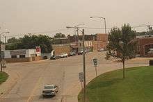
Highway 25 in Wolf Point
Highway 25's western terminus is at U.S. Route 2 in Wolf Point, Montana. The route heads northeast parallel to US 2 and a railroad. After bending southeastward, it passes the Lyman Clayton Airport and the Airport Golf Club, ending at Montana Highway 13, just to the north of the Missouri River.[2]
History
During the 1930s, an old alignment of Highway 25 existed from Lewistown to Billings.
Major intersections
The entire route is in Roosevelt County.
| Location | mi[1] | km | Destinations | Notes | |
|---|---|---|---|---|---|
| Wolf Point | 0.000 | 0.000 | Western Terminus of MT 25 | ||
| Bridge Park | 5.797 | 9.329 | Eastern Terminus of MT 25 | ||
| 1.000 mi = 1.609 km; 1.000 km = 0.621 mi | |||||
See also

References
- 1 2 Montana Department of Transportation (2013). "Montana Road Log" (PDF). Helena: Montana Department of Transportation. Retrieved March 7, 2017.
- ↑ Google Maps
External links
Route map:
![]()
This article is issued from
Wikipedia.
The text is licensed under Creative Commons - Attribution - Sharealike.
Additional terms may apply for the media files.