Carter County, Montana
| Carter County, Montana | |
|---|---|
 Carter County Courthouse in Ekalaka | |
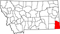 Location in the U.S. state of Montana | |
 Montana's location in the U.S. | |
| Founded | 1917 |
| Named for | Thomas H. Carter |
| Seat | Ekalaka |
| Largest town | Ekalaka |
| Area | |
| • Total | 3,348 sq mi (8,671 km2) |
| • Land | 3,341 sq mi (8,653 km2) |
| • Water | 7.5 sq mi (19 km2), 0.2% |
| Population (est.) | |
| • (2017) | 1,222[1] |
| • Density | 0.4/sq mi (0.2/km2) |
| Congressional district | At-large |
| Time zone | Mountain: UTC−7/−6 |
| Website |
www |

Carter County is a county located in the U.S. state of Montana. As of the 2010 census, the population was 1,160,[2] making it the fifth-least populous county in Montana. The county seat is Ekalaka.[3]
History
Carter County was named for Thomas Henry Carter, the first congressman from Montana. Prior to settlement the land was occupied by the Sioux tribe.[4]
Geography
According to the U.S. Census Bureau, the county has a total area of 3,348 square miles (8,670 km2), of which 3,341 square miles (8,650 km2) is land and 7.5 square miles (19 km2) (0.2%) is water.[5]
Medicine Rocks State Park is located 14 miles north of Ekalaka. Weathering has given the rocks an unusual texture. The site was used by Indian hunting parties.[6]
Adjacent counties
- Powder River County, Montana - west
- Custer County, Montana - northwest
- Fallon County, Montana - north
- Harding County, South Dakota - east
- Butte County, South Dakota - southeast
- Crook County, Wyoming - south
National protected area
- Custer National Forest (part)
Politics
| Year | Republican | Democratic | Third parties |
|---|---|---|---|
| 2016 | 86.3% 678 | 8.9% 70 | 4.8% 38 |
| 2012 | 85.2% 678 | 12.1% 96 | 2.8% 22 |
| 2008 | 79.4% 573 | 15.4% 111 | 5.3% 38 |
| 2004 | 87.9% 623 | 10.7% 76 | 1.4% 10 |
| 2000 | 88.8% 573 | 8.2% 53 | 3.0% 19 |
| 1996 | 68.2% 522 | 19.6% 150 | 12.2% 93 |
| 1992 | 56.9% 497 | 17.6% 154 | 25.5% 223 |
| 1988 | 72.8% 686 | 25.7% 242 | 1.5% 14 |
| 1984 | 80.1% 823 | 18.9% 194 | 1.1% 11 |
| 1980 | 72.4% 766 | 22.4% 237 | 5.2% 55 |
| 1976 | 57.4% 558 | 35.4% 344 | 7.2% 70 |
| 1972 | 73.9% 726 | 22.2% 218 | 4.0% 39 |
| 1968 | 62.2% 624 | 26.8% 269 | 11.0% 110 |
| 1964 | 56.0% 576 | 44.0% 453 | 0.0% 0 |
| 1960 | 64.0% 688 | 35.6% 383 | 0.4% 4 |
| 1956 | 61.6% 698 | 38.5% 436 | 0.0% 0 |
| 1952 | 72.1% 921 | 27.5% 351 | 0.4% 5 |
| 1948 | 46.2% 501 | 52.4% 568 | 1.4% 15 |
| 1944 | 45.4% 507 | 54.6% 610 | 0.1% 1 |
| 1940 | 43.0% 556 | 56.8% 734 | 0.2% 2 |
| 1936 | 32.8% 464 | 65.7% 929 | 1.5% 21 |
| 1932 | 37.4% 565 | 60.6% 915 | 2.1% 31 |
| 1928 | 64.0% 763 | 35.2% 420 | 0.8% 9 |
| 1924 | 54.2% 669 | 22.9% 283 | 22.9% 283 |
| 1920 | 66.8% 782 | 29.2% 342 | 3.9% 46 |
Demographics
| Historical population | |||
|---|---|---|---|
| Census | Pop. | %± | |
| 1920 | 3,972 | — | |
| 1930 | 4,136 | 4.1% | |
| 1940 | 3,280 | −20.7% | |
| 1950 | 2,798 | −14.7% | |
| 1960 | 2,493 | −10.9% | |
| 1970 | 1,956 | −21.5% | |
| 1980 | 1,799 | −8.0% | |
| 1990 | 1,503 | −16.5% | |
| 2000 | 1,360 | −9.5% | |
| 2010 | 1,160 | −14.7% | |
| Est. 2017 | 1,222 | [8] | 5.3% |
| U.S. Decennial Census[9] 1790-1960[10] 1900-1990[11] 1990-2000[12] 2010-2015[2] | |||
2000 census
As of the census[13] of 2000, there were 1,360 people, 543 households, and 382 families residing in the county. The population density was <1/km² (<1/sq mi). There were 811 housing units at an average density of <1/km² (<1/sq mi). The racial makeup of the county was 98.60% White, 0.07% Black or African American, 0.37% Native American, 0.15% Asian, 0.29% from other races, and 0.51% from two or more races. 0.59% of the population were Hispanic or Latino of any race. 35.3% were of German, 14.0% English, 12.9% Norwegian, 11.1% Irish and 5.2% Scottish ancestry.
There were 543 households out of which 30.60% had children under the age of 18 living with them, 60.60% were married couples living together, 7.00% had a female householder with no husband present, and 29.50% were non-families. 27.10% of all households were made up of individuals and 14.90% had someone living alone who was 65 years of age or older. The average household size was 2.47 and the average family size was 2.99.
In the county, the population was spread out with 26.50% under the age of 18, 4.10% from 18 to 24, 24.90% from 25 to 44, 26.50% from 45 to 64, and 17.90% who were 65 years of age or older. The median age was 42 years. For every 100 females there were 94.80 males. For every 100 females age 18 and over, there were 96.70 males.
The median income for a household in the county was $26,313, and the median income for a family was $32,262. Males had a median income of $21,466 versus $15,703 for females. The per capita income for the county was $13,280. About 15.90% of families and 18.10% of the population were below the poverty line, including 16.20% of those under age 18 and 16.40% of those age 65 or over.
2010 census
As of the 2010 United States Census, there were 1,160 people, 532 households, and 354 families residing in the county.[14] The population density was 0.3 inhabitants per square mile (0.12/km2). There were 810 housing units at an average density of 0.2 per square mile (0.077/km2).[15] The racial makeup of the county was 97.8% white, 0.9% American Indian, 0.1% black or African American, 0.1% Asian, 0.3% from other races, and 0.8% from two or more races. Those of Hispanic or Latino origin made up 0.7% of the population.[14] In terms of ancestry, 41.5% were German, 19.6% were English, 18.8% were Norwegian, 12.3% were Irish, and 4.3% were American.[16]
Of the 532 households, 20.5% had children under the age of 18 living with them, 59.4% were married couples living together, 4.3% had a female householder with no husband present, 33.5% were non-families, and 30.3% of all households were made up of individuals. The average household size was 2.16 and the average family size was 2.65. The median age was 50.2 years.[14]
The median income for a household in the county was $35,703 and the median income for a family was $47,955. Males had a median income of $26,736 versus $18,274 for females. The per capita income for the county was $20,681. About 8.5% of families and 14.0% of the population were below the poverty line, including 20.4% of those under age 18 and 10.8% of those age 65 or over.[17]
Communities
Town
- Ekalaka (county seat)
Census-designated place
Unincorporated communities
Notable Residents
- Britt Williams, 2010 WNFR Team Roping qualifier.
See also
| Wikimedia Commons has media related to Minerals of Carter County. |
References
- ↑ https://www.census.gov/quickfacts/fact/table/cartercountymontana/PST045216
- 1 2 "State & County QuickFacts". United States Census Bureau. Retrieved September 14, 2013.
- ↑ "Find a County". National Association of Counties. Archived from the original on 2011-05-31. Retrieved 2011-06-07.
- ↑ Merrill, Andrea; Judy Jacobson (1997). Montana almanac. Helena, Montana: Falcon Publishing. ISBN 1-56044-493-2.
- ↑ "2010 Census Gazetteer Files". United States Census Bureau. August 22, 2012. Archived from the original on December 5, 2014. Retrieved November 27, 2014.
- ↑ Visit MT. "Medicine Rocks State Park". Archived from the original on 17 July 2011. Retrieved 20 July 2011.
- ↑ Leip, David. "Dave Leip's Atlas of U.S. Presidential Elections". uselectionatlas.org. Retrieved 2018-04-02.
- ↑ "Population and Housing Unit Estimates". Retrieved June 9, 2017.
- ↑ "U.S. Decennial Census". United States Census Bureau. Archived from the original on April 22, 2013. Retrieved November 27, 2014.
- ↑ "Historical Census Browser". University of Virginia Library. Retrieved November 27, 2014.
- ↑ "Population of Counties by Decennial Census: 1900 to 1990". United States Census Bureau. Retrieved November 27, 2014.
- ↑ "Census 2000 PHC-T-4. Ranking Tables for Counties: 1990 and 2000" (PDF). United States Census Bureau. Retrieved November 27, 2014.
- ↑ "American FactFinder". United States Census Bureau. Archived from the original on 2013-09-11. Retrieved 2008-01-31.
- 1 2 3 "DP-1 Profile of General Population and Housing Characteristics: 2010 Demographic Profile Data". United States Census Bureau. Retrieved 2016-01-09.
- ↑ "Population, Housing Units, Area, and Density: 2010 - County". United States Census Bureau. Retrieved 2016-01-09.
- ↑ "DP02 SELECTED SOCIAL CHARACTERISTICS IN THE UNITED STATES – 2006-2010 American Community Survey 5-Year Estimates". United States Census Bureau. Retrieved 2016-01-09.
- ↑ "DP03 SELECTED ECONOMIC CHARACTERISTICS – 2006-2010 American Community Survey 5-Year Estimates". United States Census Bureau. Retrieved 2016-01-09.
External links
| Wikimedia Commons has media related to Carter County, Montana. |
Places adjacent to Carter County, Montana | |
|---|---|
Municipalities and communities of Carter County, Montana, United States | ||
|---|---|---|
| Town | | |
| CDP | ||
| Other unincorporated communities | ||
| Indian reservation | ||
| Footnotes | ‡This populated place also has portions in an adjacent county or counties | |
