Broadwater County, Montana
| Broadwater County, Montana | |
|---|---|
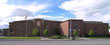 The Broadwater County Courthouse in Townsend | |
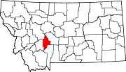 Location in the U.S. state of Montana | |
 Montana's location in the U.S. | |
| Founded | 1897 |
| Named for | Charles Arthur Broadwater |
| Seat | Townsend |
| Largest city | Townsend |
| Area | |
| • Total | 1,239 sq mi (3,209 km2) |
| • Land | 1,193 sq mi (3,090 km2) |
| • Water | 46 sq mi (119 km2), 3.7% |
| Population (est.) | |
| • (2016) | 5,747 |
| • Density | 4.8/sq mi (1.9/km2) |
| Congressional district | At-large |
| Time zone | Mountain: UTC−7/−6 |
| Website |
www |
Broadwater County is a county in the U.S. state of Montana. As of the 2010 census, the population was 5,612.[1] Its county seat is Townsend.[2] The county was named for Charles Arthur Broadwater, a noted Montana railroad, real estate, and banking magnate.[3]
History

The Lewis and Clark Expedition travelled through what is now Broadwater County as they traced the Missouri River. Gold was discovered in the Big Belt Mountains in 1864 which brought several mining towns. In 1881 the Northern Pacific Railway with a stop in what is now Townsend.[4]
Geography
According to the U.S. Census Bureau, the county has a total area of 1,239 square miles (3,210 km2), of which 1,193 square miles (3,090 km2) is land and 46 square miles (120 km2) (3.7%) is water.[5]
The boundaries of the county are roughly formed by the Big Belt Mountains to the east and north, the Elkhorn Mountains to the west, and the Horseshoe Hills to the south.
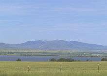
Broadwater County is perhaps best known as the home of Canyon Ferry Lake, the third largest body of water in Montana. The lake provides essential irrigation to local farms, and serves as a recreation destination for the region. Visitors seek out Canyon Ferry for its excellent fishing, boating, swimming, camping, and wildlife viewing opportunities.[6]
Major highways
Adjacent counties
- Meagher County, Montana - east
- Gallatin County, Montana - south
- Jefferson County, Montana - west
- Lewis and Clark County, Montana - northwest
National protected area
- Helena National Forest (part)
Politics
| Year | Republican | Democratic | Third parties |
|---|---|---|---|
| 2016 | 74.9% 2,348 | 18.3% 573 | 6.8% 212 |
| 2012 | 71.5% 2,152 | 25.4% 764 | 3.2% 95 |
| 2008 | 66.8% 1,875 | 30.5% 857 | 2.7% 75 |
| 2004 | 75.5% 1,778 | 22.6% 533 | 1.9% 45 |
| 2000 | 71.8% 1,488 | 22.3% 462 | 6.0% 124 |
| 1996 | 52.3% 1,029 | 30.7% 603 | 17.0% 334 |
| 1992 | 45.1% 830 | 26.7% 491 | 28.3% 521 |
| 1988 | 62.6% 1,054 | 35.2% 592 | 2.2% 37 |
| 1984 | 73.5% 1,345 | 25.0% 458 | 1.5% 27 |
| 1980 | 67.3% 1,052 | 25.6% 401 | 7.1% 111 |
| 1976 | 59.0% 820 | 40.1% 557 | 0.9% 12 |
| 1972 | 66.6% 916 | 29.9% 411 | 3.6% 49 |
| 1968 | 54.3% 671 | 35.5% 439 | 10.2% 126 |
| 1964 | 50.6% 609 | 49.4% 595 | 0.0% 0 |
| 1960 | 51.9% 680 | 48.1% 631 | 0.0% 0 |
| 1956 | 65.9% 869 | 34.1% 449 | 0.0% 0 |
| 1952 | 68.9% 962 | 31.1% 435 | 0.0% 0 |
| 1948 | 55.6% 704 | 42.3% 536 | 2.1% 26 |
| 1944 | 57.5% 760 | 42.2% 558 | 0.4% 5 |
| 1940 | 46.8% 755 | 52.9% 854 | 0.3% 4 |
| 1936 | 31.4% 502 | 67.1% 1,071 | 1.5% 24 |
| 1932 | 33.7% 512 | 65.0% 988 | 1.3% 19 |
| 1928 | 52.5% 743 | 46.9% 663 | 0.6% 9 |
| 1924 | 37.7% 531 | 34.5% 486 | 27.8% 391 |
| 1920 | 51.5% 723 | 44.3% 622 | 4.2% 59 |
| 1916 | 33.5% 584 | 63.0% 1,100 | 3.6% 62 |
| 1912 | 22.0% 205 | 48.3% 451 | 29.7% 277 |
| 1908 | 37.9% 326 | 57.5% 495 | 4.7% 40 |
| 1904 | 44.9% 392 | 46.2% 403 | 8.9% 78 |
Demographics
| Historical population | |||
|---|---|---|---|
| Census | Pop. | %± | |
| 1900 | 2,641 | — | |
| 1910 | 3,491 | 32.2% | |
| 1920 | 3,239 | −7.2% | |
| 1930 | 2,738 | −15.5% | |
| 1940 | 3,451 | 26.0% | |
| 1950 | 2,922 | −15.3% | |
| 1960 | 2,804 | −4.0% | |
| 1970 | 2,526 | −9.9% | |
| 1980 | 3,267 | 29.3% | |
| 1990 | 3,318 | 1.6% | |
| 2000 | 4,385 | 32.2% | |
| 2010 | 5,612 | 28.0% | |
| Est. 2016 | 5,747 | [8] | 2.4% |
| U.S. Decennial Census[9] 1790-1960[10] 1900-1990[11] 1990-2000[12] 2010-2015[1] | |||
2000 census
As of the census[13] of 2000, there were 4,385 people, 1,752 households, and 1,270 families residing in the county. The population density was 4 people per square mile (1/km²). There were 2,002 housing units at an average density of 2 per square mile (1/km²). The racial makeup of the county was 97.04% White, 0.27% Black or African American, 1.16% Native American, 0.11% Asian, 0.07% Pacific Islander, 0.34% from other races, and 1.00% from two or more races. 1.32% of the population were Hispanic or Latino of any race. 25.5% were of German, 14.5% English, 12.9% Irish, 9.9% Norwegian and 6.3% French ancestry. 98.0% spoke English and 1.3% German as their first language.
There were 1,752 households out of which 30.10% had children under the age of 18 living with them, 61.40% were married couples living together, 6.90% had a female householder with no husband present, and 27.50% were non-families. 24.10% of all households were made up of individuals and 9.90% had someone living alone who was 65 years of age or older. The average household size was 2.47 and the average family size was 2.91.
In the county, the population was spread out with 25.20% under the age of 18, 4.80% from 18 to 24, 26.20% from 25 to 44, 27.40% from 45 to 64, and 16.40% who were 65 years of age or older. The median age was 41 years. For every 100 females there were 104.00 males. For every 100 females age 18 and over, there were 103.70 males.
The median income for a household in the county was $32,689, and the median income for a family was $36,524. Males had a median income of $28,495 versus $19,500 for females. The per capita income for the county was $16,237. About 7.60% of families and 10.80% of the population were below the poverty line, including 13.70% of those under age 18 and 7.90% of those age 65 or over.
2010 census
As of the 2010 United States Census, there were 5,612 people, 2,347 households, and 1,614 families residing in the county.[14] The population density was 4.7 inhabitants per square mile (1.8/km2). There were 2,695 housing units at an average density of 2.3 per square mile (0.89/km2).[15] The racial makeup of the county was 96.2% white, 1.3% American Indian, 0.3% black or African American, 0.2% Pacific islander, 0.2% Asian, 0.3% from other races, and 1.5% from two or more races. Those of Hispanic or Latino origin made up 2.2% of the population.[14] In terms of ancestry, 38.7% were German, 16.2% were English, 15.5% were Irish, 7.9% were Norwegian, 6.4% were Scottish, and 2.3% were American.[16]
Of the 2,347 households, 27.5% had children under the age of 18 living with them, 58.7% were married couples living together, 6.2% had a female householder with no husband present, 31.2% were non-families, and 26.6% of all households were made up of individuals. The average household size was 2.37 and the average family size was 2.85. The median age was 45.4 years.[14]
The median income for a household in the county was $44,667 and the median income for a family was $46,949. Males had a median income of $34,500 versus $32,014 for females. The per capita income for the county was $19,606. About 5.8% of families and 10.1% of the population were below the poverty line, including 10.0% of those under age 18 and 7.1% of those age 65 or over.[17]
Economy
Agriculture is one of the primary industries in Broadwater County. RY Timber and Wheat Montana Bakery were the largest private employers according to the 2000 Census.[6]
Communities
City
- Townsend (county seat)
Census-designated places
Unincorporated community
See also
References
- 1 2 "State & County QuickFacts". United States Census Bureau. Retrieved September 14, 2013.
- ↑ "Find a County". National Association of Counties. Archived from the original on 2011-05-31. Retrieved 2011-06-07.
- ↑ Merrill, Andrea; Judy Jacobson (1997). Montana almanac. Helena, Montana: Falcon Publishing. p. 7. ISBN 1-56044-493-2.
- ↑ Broadwater County Planning Board (July 2003). "Broadwater County Growth Policy Plan". Archived from the original on 13 August 2011. Retrieved 1 June 2011.
- ↑ "2010 Census Gazetteer Files". United States Census Bureau. August 22, 2012. Archived from the original on December 5, 2014. Retrieved November 27, 2014.
- 1 2 State of Montana (2006). "Demographic & economic information for Broadwater County". Internet Archive. Retrieved 1 June 2011.
- ↑ Leip, David. "Dave Leip's Atlas of U.S. Presidential Elections". uselectionatlas.org. Retrieved 2018-04-02.
- ↑ "Population and Housing Unit Estimates". Retrieved June 9, 2017.
- ↑ "U.S. Decennial Census". United States Census Bureau. Archived from the original on May 12, 2015. Retrieved November 27, 2014.
- ↑ "Historical Census Browser". University of Virginia Library. Retrieved November 27, 2014.
- ↑ "Population of Counties by Decennial Census: 1900 to 1990". United States Census Bureau. Retrieved November 27, 2014.
- ↑ "Census 2000 PHC-T-4. Ranking Tables for Counties: 1990 and 2000" (PDF). United States Census Bureau. Retrieved November 27, 2014.
- ↑ "American FactFinder". United States Census Bureau. Archived from the original on 2013-09-11. Retrieved 2008-01-31.
- 1 2 3 "DP-1 Profile of General Population and Housing Characteristics: 2010 Demographic Profile Data". United States Census Bureau. Retrieved 2016-01-09.
- ↑ "Population, Housing Units, Area, and Density: 2010 - County". United States Census Bureau. Retrieved 2016-01-09.
- ↑ "DP02 SELECTED SOCIAL CHARACTERISTICS IN THE UNITED STATES – 2006-2010 American Community Survey 5-Year Estimates". United States Census Bureau. Retrieved 2016-01-09.
- ↑ "DP03 SELECTED ECONOMIC CHARACTERISTICS – 2006-2010 American Community Survey 5-Year Estimates". United States Census Bureau. Retrieved 2016-01-09.
External links
Places adjacent to Broadwater County, Montana | ||||||||||
|---|---|---|---|---|---|---|---|---|---|---|
| ||||||||||
Municipalities and communities of Broadwater County, Montana, United States | ||
|---|---|---|
| City | | |
| CDPs | ||
| Unincorporated community | ||
