Okhaldhunga District
| Okhaldhunga District ओखलढुङ्गा जिल्ला | |
|---|---|
| District | |
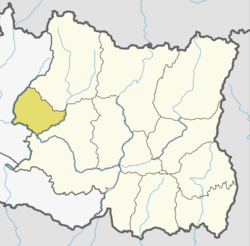 | |
| Country | Nepal |
| Province | Province No. 1 |
| Admin HQ. | Siddhicharan Municipality |
| Government | |
| • Type | Coordination committee |
| • Body | DCC, Okhaldhunga |
| Area | |
| • Total | 1,074 km2 (415 sq mi) |
| Population (2011) | |
| • Total | 147,984 |
| • Density | 140/km2 (360/sq mi) |
| Time zone | UTC+5:45 (NPT) |
| Main Language(s) |
Nepali language (official) Rai language, Sunuwar language |
| Website |
ddcokhaldhunga |
Okhaldhunga District (Nepali: ओखलढुङ्गा जिल्ला![]()
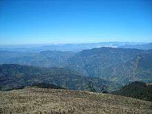
Geography and Climate
| Climate Zone[2] | Elevation Range | % of Area |
|---|---|---|
| Upper Tropical | 300 to 1,000 meters 1,000 to 3,300 ft. |
22.2% |
| Subtropical | 1,000 to 2,000 meters 3,300 to 6,600 ft. |
51.1% |
| Temperate | 2,000 to 3,000 meters 6,400 to 9,800 ft. |
24.2% |
| Subalpine | 3,000 to 4,000 meters 9,800 to 13,100 ft. |
2.1% |
Village Development Committees

The district contains the following VDCs from 2017:
Andheri Narayansthan, Baksa, Balakhu, Barnalu, Baruneshwor, Betini, Bhadaure, Bhussinga, Bigutar, Bilandu, Chyanam, Diyale, Fediguth, Fulbari, Gamnangtar, Harkapur, Jantarkhani, Jyamire, Kalikadevi, Khijikati, Katunje, Ketuke, Khiji Chandeshwori, Khijifalate, Kuibhir, Kuntadevi, Madhavpur, Mamkha, Manebhanjyang, Moli, Mulkharka, Narmedeshwor, Okhaldhunga, Palapu, Patle, Pokali, Pokhare, Prapcha, Ragadip, Ragani, Raniban, Ratmate, Rawadolu, Rumjatar, Salleri, Serna, Shreechaur, Singhadevi, Sisneri, Taluwa, Tarkerabari, Thakle, Thoksela, Thulachhap, Ubu, Yasam
Municipality
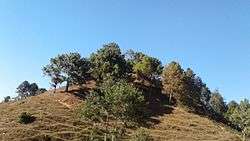
Tourist area
Khijee Tholedamba Tourist are attracted towards the beauty of Khiji Okhaldhunga.
See also
References
- ↑ Household and population by districts, Central Bureau of Statistics (CBS) Nepal Archived July 31, 2013, at the Wayback Machine.
- ↑ The Map of Potential Vegetation of Nepal - a forestry/agroecological/biodiversity classification system (PDF), Forest & Landscape Development and Environment Series 2-2005 and CFC-TIS Document Series No.110., 2005, ISBN 87-7903-210-9, retrieved Nov 22, 2013
- "Districts of Nepal". Statoids.
| Wikimedia Commons has media related to Okhaldhunga District. |
Places adjacent to Okhaldhunga District | ||||||||||
|---|---|---|---|---|---|---|---|---|---|---|
| ||||||||||
Headquarter: Okhaldhunga | ||
| Urban Municipality | | |
| Rural Municipality | ||
| Province No. 1 |  | |
|---|---|---|
| Province No. 2 | ||
| Province No. 3 | ||
| Gandaki Pradesh | ||
| Province No. 5 | ||
| Karnali Pradesh | ||
| Sudurpashchim Pradesh | ||
Coordinates: 27°19′N 86°30′E / 27.317°N 86.500°E