Neussargues en Pinatelle
| Neussargues en Pinatelle | |
|---|---|
| Commune | |
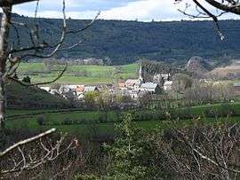 A general view of Neussargues | |
 Neussargues en Pinatelle Location within Auvergne-Rhône-Alpes region  Neussargues en Pinatelle | |
| Coordinates: 45°07′45″N 2°58′37″E / 45.1292°N 2.9769°ECoordinates: 45°07′45″N 2°58′37″E / 45.1292°N 2.9769°E | |
| Country | France |
| Region | Auvergne-Rhône-Alpes |
| Department | Cantal |
| Arrondissement | Saint-Flour |
| Canton | Murat |
| Intercommunality | Hautes Terres |
| Area1 | 91.98 km2 (35.51 sq mi) |
| Population (2014)2 | 1,897 |
| • Density | 21/km2 (53/sq mi) |
| Time zone | UTC+1 (CET) |
| • Summer (DST) | UTC+2 (CEST) |
| INSEE/Postal code | 15141 /15170 |
|
1 French Land Register data, which excludes lakes, ponds, glaciers > 1 km2 (0.386 sq mi or 247 acres) and river estuaries. 2 Population without double counting: residents of multiple communes (e.g., students and military personnel) only counted once. | |
Neussargues en Pinatelle is a commune in the Cantal department in south-central France. The municipality was established on 1 December 2016 and consists of the former communes of Celles, Chalinargues, Chavagnac, Neussargues-Moissac and Sainte-Anastasie.[1][2]
See also
References
| Wikimedia Commons has media related to Neussargues en Pinatelle. |
- ↑ Arrêté préfectoral 21 September 2016 (in French)
- ↑ Arrêté préfectoral, correcting the creation date
This article is issued from
Wikipedia.
The text is licensed under Creative Commons - Attribution - Sharealike.
Additional terms may apply for the media files.