Parlan
| Parlan | |
|---|---|
| Commune | |
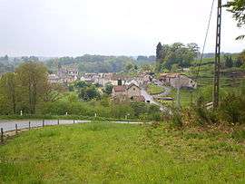 A general view of Parlan | |
 Parlan Location within Auvergne-Rhône-Alpes region  Parlan | |
| Coordinates: 44°49′48″N 2°10′24″E / 44.83°N 2.1733°ECoordinates: 44°49′48″N 2°10′24″E / 44.83°N 2.1733°E | |
| Country | France |
| Region | Auvergne-Rhône-Alpes |
| Department | Cantal |
| Arrondissement | Aurillac |
| Canton | Saint-Paul-des-Landes |
| Intercommunality | entre Cère et Rance |
| Government | |
| • Mayor (2008–2014) | Michel Teyssedou |
| Area1 | 24.12 km2 (9.31 sq mi) |
| Population (2008)2 | 307 |
| • Density | 13/km2 (33/sq mi) |
| Time zone | UTC+1 (CET) |
| • Summer (DST) | UTC+2 (CEST) |
| INSEE/Postal code | 15147 /15290 |
| Elevation |
510–743 m (1,673–2,438 ft) (avg. 492 m or 1,614 ft) |
|
1 French Land Register data, which excludes lakes, ponds, glaciers > 1 km2 (0.386 sq mi or 247 acres) and river estuaries. 2 Population without double counting: residents of multiple communes (e.g., students and military personnel) only counted once. | |
Parlan is a commune in the Cantal department in south-central France.
Population
| Historical population | ||
|---|---|---|
| Year | Pop. | ±% |
| 1962 | 377 | — |
| 1968 | 442 | +17.2% |
| 1975 | 409 | −7.5% |
| 1982 | 360 | −12.0% |
| 1990 | 323 | −10.3% |
| 1999 | 280 | −13.3% |
| 2006 | 302 | +7.9% |
| 2008 | 307 | +1.7% |
See also
References
| Wikimedia Commons has media related to Parlan. |
This article is issued from
Wikipedia.
The text is licensed under Creative Commons - Attribution - Sharealike.
Additional terms may apply for the media files.