Saint-Poncy
| Saint-Poncy | |
|---|---|
| Commune | |
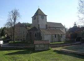 The church in Saint-Poncy | |
 Saint-Poncy Location within Auvergne-Rhône-Alpes region  Saint-Poncy | |
| Coordinates: 45°09′56″N 3°11′15″E / 45.1656°N 3.1875°ECoordinates: 45°09′56″N 3°11′15″E / 45.1656°N 3.1875°E | |
| Country | France |
| Region | Auvergne-Rhône-Alpes |
| Department | Cantal |
| Arrondissement | Saint-Flour |
| Canton | Saint-Flour-1 |
| Intercommunality | Pays de Massiac |
| Government | |
| • Mayor (2008–2014) | Jacques Couvret |
| Area1 | 40.37 km2 (15.59 sq mi) |
| Population (2008)2 | 324 |
| • Density | 8.0/km2 (21/sq mi) |
| Time zone | UTC+1 (CET) |
| • Summer (DST) | UTC+2 (CEST) |
| INSEE/Postal code | 15207 /15500 |
| Elevation |
599–1,065 m (1,965–3,494 ft) (avg. 826 m or 2,710 ft) |
|
1 French Land Register data, which excludes lakes, ponds, glaciers > 1 km2 (0.386 sq mi or 247 acres) and river estuaries. 2 Population without double counting: residents of multiple communes (e.g., students and military personnel) only counted once. | |
Saint-Poncy is a commune in the Cantal department in south-central France.
Population
| Historical population | ||
|---|---|---|
| Year | Pop. | ±% |
| 1962 | 409 | — |
| 1968 | 473 | +15.6% |
| 1975 | 445 | −5.9% |
| 1982 | 418 | −6.1% |
| 1990 | 376 | −10.0% |
| 1999 | 341 | −9.3% |
| 2008 | 324 | −5.0% |
See also
References
| Wikimedia Commons has media related to Saint-Poncy. |
This article is issued from
Wikipedia.
The text is licensed under Creative Commons - Attribution - Sharealike.
Additional terms may apply for the media files.