Sénezergues
| Sénezergues | |
|---|---|
| Commune | |
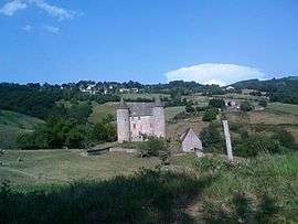 The Château of Sénezergues | |
 Sénezergues Location within Auvergne-Rhône-Alpes region  Sénezergues | |
| Coordinates: 44°42′12″N 2°24′50″E / 44.7033°N 2.4139°ECoordinates: 44°42′12″N 2°24′50″E / 44.7033°N 2.4139°E | |
| Country | France |
| Region | Auvergne-Rhône-Alpes |
| Department | Cantal |
| Arrondissement | Aurillac |
| Canton | Arpajon-sur-Cère |
| Intercommunality | Montsalvy |
| Government | |
| • Mayor (2008–2014) | Chantal Delouvrier |
| Area1 | 17.61 km2 (6.80 sq mi) |
| Population (2008)2 | 193 |
| • Density | 11/km2 (28/sq mi) |
| Time zone | UTC+1 (CET) |
| • Summer (DST) | UTC+2 (CEST) |
| INSEE/Postal code | 15226 /15340 |
| Elevation |
278–795 m (912–2,608 ft) (avg. 480 m or 1,570 ft) |
|
1 French Land Register data, which excludes lakes, ponds, glaciers > 1 km2 (0.386 sq mi or 247 acres) and river estuaries. 2 Population without double counting: residents of multiple communes (e.g., students and military personnel) only counted once. | |
Sénezergues is a commune in the Cantal department in south-central France.
Population
| Historical population | ||
|---|---|---|
| Year | Pop. | ±% |
| 1962 | 248 | — |
| 1968 | 310 | +25.0% |
| 1975 | 305 | −1.6% |
| 1982 | 278 | −8.9% |
| 1990 | 270 | −2.9% |
| 1999 | 230 | −14.8% |
| 2008 | 193 | −16.1% |
See also
References
| Wikimedia Commons has media related to Sénezergues. |
This article is issued from
Wikipedia.
The text is licensed under Creative Commons - Attribution - Sharealike.
Additional terms may apply for the media files.