Allanche
| Allanche | ||
|---|---|---|
| Commune | ||
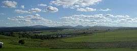 View from Chavanon | ||
| ||
 Allanche Location within Auvergne-Rhône-Alpes region  Allanche | ||
| Coordinates: 45°13′48″N 2°56′07″E / 45.23°N 2.9353°ECoordinates: 45°13′48″N 2°56′07″E / 45.23°N 2.9353°E | ||
| Country | France | |
| Region | Auvergne-Rhône-Alpes | |
| Department | Cantal | |
| Arrondissement | Saint-Flour | |
| Canton | Murat | |
| Intercommunality | Cézallier | |
| Government | ||
| • Mayor (2016-2020) | Philippe Rosseel | |
| Area1 | 49.89 km2 (19.26 sq mi) | |
| Population (2014)2 | 771 | |
| • Density | 15/km2 (40/sq mi) | |
| Time zone | UTC+1 (CET) | |
| • Summer (DST) | UTC+2 (CEST) | |
| INSEE/Postal code | 15001 /15160 | |
| Elevation |
784–1,295 m (2,572–4,249 ft) (avg. 968 m or 3,176 ft) | |
|
1 French Land Register data, which excludes lakes, ponds, glaciers > 1 km2 (0.386 sq mi or 247 acres) and river estuaries. 2 Population without double counting: residents of multiple communes (e.g., students and military personnel) only counted once. | ||
Allanche is a commune in the Cantal department in the Auvergne region of south-central France.
The inhabitants of the commune are known as Allanchois or Allanchoises[1]
Geography
Allanche is located some 70 km south of Clermont-Ferrand and 20 km east by southeast of Massiac. It can be accessed by the D679 from Marcenat in the northwest to the village then south to Sainte-Anastasie. The D39 comes from Pradiers in the north through the village then south to Chalinargues. The D9 road branches off the D3 to the west of the commune and passes through the village continuing to the northeast. Apart from the village there are a number of hamlets. These are:
- Chastre
- Chavanon
- Coudour
- Feydit
- Le Bac Bas
- Le Bac Haut
- Les Cites
- Maillargues
- Roche Haut
- Romaniargues
The commune is largely farmland with patches of forest and the edge of a large forest in the east.[2]
The Allanche river flows from the northwest through the village and continues southeast to feed the Alagnon river. Many tributaries feed the Allanche in the commune including the Ruisseau de Laneyrat, the Ruisseau de Coudoun, the Ruisseau de Chavanon, the Ruisseau de Vernois, and other unnamed streams.[2]
Neighbouring communes and villages[2]
Places adjacent to Allanche | |
|---|---|
Heraldry
 |
Blazon: Or, two keys saltirewise in sable. |
Administration
List of Successive Mayors[3]
| From | To | Name | Party | Position |
|---|---|---|---|---|
| 1792 | 1800 | Antoine Gabriel Benoid | ||
| 1800 | 1802 | Jean Pierre Feydin | ||
| 1802 | 1805 | Guillaume Peuvergne | ||
| 1805 | 1813 | Jean Pierre Feydin | ||
| 1813 | 1830 | Antoine Gabriel Benoid | ||
| 1830 | 1838 | Jean Benoit Bertrand | ||
| 1838 | 1855 | Jean Pierre Catinaud | ||
| 1855 | 1874 | Louis Bonnet | ||
| 1874 | 1880 | Gabriel Charles Bonnet | ||
| 1880 | 1890 | Jules Magot | ||
| 1890 | 1896 | Auguste Dellac | ||
| 1896 | 1903 | Henri Bonnet | ||
| 1903 | 1904 | Jean Romain Faucillon | ||
| 1904 | 1919 | Justin Veisset | ||
| 1919 | 1929 | Léon Parlier | ||
| 1929 | 1932 | Albert Chastel | ||
| 1932 | 1935 | Roger Albeine | ||
| 1935 | 1941 | Jules Eugène Farradeche |
- Mayors from 1941
| From | To | Name | Party | Position |
|---|---|---|---|---|
| 1941 | 1944 | Léon Parlier | ||
| 1944 | 1948 | Jules Eugène Farradeche | ||
| 1948 | 1971 | Maurice Peschaud | ||
| 1971 | 1995 | Pierre Jarry | ||
| 1995 | 2001 | Christian LÉOTY | ||
| 2001 | 2008 | André Papon | ||
| 2008 | 2020 | Christian Léoty | SE |
(Not all data is known)
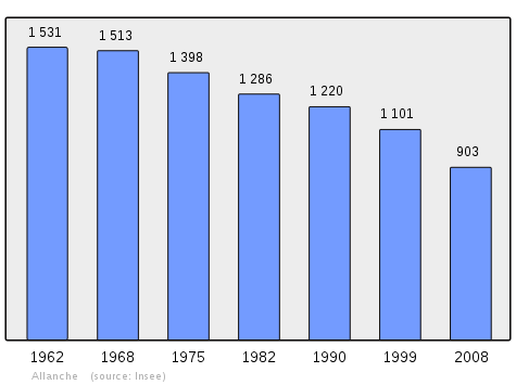
Demography
In 2010 the commune had 891 inhabitants. The evolution of the number of inhabitants is known through the population censuses conducted in the commune since 1793. From the 21st century, a census of communes with fewer than 10,000 inhabitants is held every five years, unlike larger towns that have a sample survey every year.[Note 1]
| 1793 | 1800 | 1806 | 1821 | 1831 | 1836 | 1841 | 1846 | 1851 |
|---|---|---|---|---|---|---|---|---|
| 2,497 | 2,020 | 2,508 | 2,394 | 2,501 | 2,534 | 2,605 | 2,583 | 2,356 |
| 1856 | 1861 | 1866 | 1872 | 1876 | 1881 | 1886 | 1891 | 1896 |
|---|---|---|---|---|---|---|---|---|
| 2,288 | 2,125 | 2,056 | 1,839 | 1,959 | 1,987 | 2,013 | 1,885 | 1,890 |
| 1901 | 1906 | 1911 | 1921 | 1926 | 1931 | 1936 | 1946 | 1954 |
|---|---|---|---|---|---|---|---|---|
| 1,996 | 1,760 | 1,809 | 1,889 | 1,687 | 1,792 | 1,646 | 1,536 | 1,467 |
| 1962 | 1968 | 1975 | 1982 | 1990 | 1999 | 2006 | 2008 | 2010 |
|---|---|---|---|---|---|---|---|---|
| 1,478 | 1,513 | 1,398 | 1,286 | 1,220 | 1,101 | 947 | 903 | 891 |
Sources : Ldh/EHESS/Cassini until 1962, INSEE database from 1968 (population without double counting and municipal population from 2006)
Culture and heritage
Civil heritage
Religious heritage
The commune has two religious buildings and structures that are registered as historical monuments:
- The Church of Saint-Julien-de-Chanet (12th century).

- The Church of Saint John the Baptist (12th century).
- Other religious sites of interest
Church of Saint John the Baptist Picture Gallery
 The church
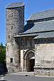 Entrance and Tower
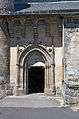 The entrance
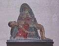 The pieta in the church
Notable people linked to the commune
- Charles Ganilh (1758-1836), economist, was born in Allanche.
See also
- Communes of the Cantal department
- Cantons of the Cantal department
- Arrondissements of the Cantal department
Bibliography
- Our Auvergne ancestors, the Auvergne migration to Brittany, Serge Duigou, Éditions Ressac, Quimper, 2004. [On the Cézallier migratory movement to Brittany in the 18th and 19th centuries which included Allanche together with Albaret, Chabrier, Laymet, Mainhes, etc..] (in French)
External links
- Allanche on the old National Geographic Institute website (in French)
- Allanche on Lion1906
- Allanche on Google Maps
- Allanche on Géoportail, National Geographic Institute (IGN) website (in French)
- Allanche on the 1750 Cassini Map
- Allanche on the INSEE website (in French)
- INSEE (in French)
Notes and references
Notes
- ↑ At the beginning of the 21st century, the methods of identification have been modified by law No. 2002-276 of 27 February 2002 Archived 2016-03-06 at the Wayback Machine., the so-called "law of local democracy" and in particular Title V "census operations" which allow, after a transitional period running from 2004 to 2008, the annual publication of the legal population of the different French administrative districts. For municipalities with a population greater than 10,000 inhabitants, a sample survey is conducted annually, the entire territory of these municipalities is taken into account at the end of the period of five years. The first "legal population" after 1999 under this new law came into force on 1 January 2009 and was based on the census of 2006.
References
- ↑ Inhabitants of Cantal (in French)
- 1 2 3 Google Maps
- ↑ List of Mayors of France
- ↑ Ministry of Culture, Mérimée PA00093428 Château de Mercoeur (in French)
- ↑ Ministry of Culture, Mérimée PA00093430 Church of Saint-Julien-de-Chanet (in French)

- ↑ Ministry of Culture, Palissy PM15000037 Main Altar and Retable
(in French)
- ↑ Ministry of Culture, Palissy PM15000036 Statue: Virgin and child
(in French)
- ↑ Ministry of Culture, Palissy PM15000035 Group Sculpture: Virgin of Pity
(in French)
- ↑ Ministry of Culture, Palissy PM15000034 Painting: the Adoration of the Magi
(in French)
- ↑ Ministry of Culture, Palissy PM15000033 Bas-reliefs
(in French)
- ↑ Ministry of Culture, Mérimée PA00093429 Church of Saint John the Baptist (in French)
- ↑ Ministry of Culture, Palissy PM15000730 Sculpture: Ecce homo
(in French)
- ↑ Ministry of Culture, Palissy PM15000580 Eagle Lectern
(in French)
- ↑ Ministry of Culture, Palissy PM15000040 Bronze Bell
(in French)
- ↑ Ministry of Culture, Palissy PM15000032 Set of Pews
(in French)
- ↑ Ministry of Culture, Palissy IM15001405 Reliquary-Monstrance (in French)
- ↑ Ministry of Culture, Palissy IM15000001 Processional Cross
(in French)
- ↑ Ministry of Culture, Palissy PM15000039 Reliquary
(in French)
- ↑ Ministry of Culture, Palissy PM15000038 Processional Cross
(in French)
| Wikimedia Commons has media related to Allanche. |