Marmanhac
| Marmanhac | ||
|---|---|---|
| Commune | ||
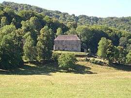 Chateau of Estang | ||
| ||
 Marmanhac Location within Auvergne-Rhône-Alpes region  Marmanhac | ||
| Coordinates: 45°00′16″N 2°28′59″E / 45.0044°N 2.4831°ECoordinates: 45°00′16″N 2°28′59″E / 45.0044°N 2.4831°E | ||
| Country | France | |
| Region | Auvergne-Rhône-Alpes | |
| Department | Cantal | |
| Arrondissement | Aurillac | |
| Canton | Naucelles | |
| Intercommunality | CA Bassin d'Aurillac | |
| Government | ||
| • Mayor (2008–2014) | Laurent Tellier | |
| Area1 | 24.24 km2 (9.36 sq mi) | |
| Population (2008)2 | 736 | |
| • Density | 30/km2 (79/sq mi) | |
| Time zone | UTC+1 (CET) | |
| • Summer (DST) | UTC+2 (CEST) | |
| INSEE/Postal code | 15118 /15250 | |
| Elevation | 627–971 m (2,057–3,186 ft) | |
|
1 French Land Register data, which excludes lakes, ponds, glaciers > 1 km2 (0.386 sq mi or 247 acres) and river estuaries. 2 Population without double counting: residents of multiple communes (e.g., students and military personnel) only counted once. | ||

Marmanhac is a commune in the Cantal department in south-central France.
Population
| Historical population | ||
|---|---|---|
| Year | Pop. | ±% |
| 1962 | 841 | — |
| 1968 | 863 | +2.6% |
| 1975 | 890 | +3.1% |
| 1982 | 789 | −11.3% |
| 1990 | 749 | −5.1% |
| 1999 | 706 | −5.7% |
| 2008 | 736 | +4.2% |
See also
References
| Wikimedia Commons has media related to Marmanhac. |
This article is issued from
Wikipedia.
The text is licensed under Creative Commons - Attribution - Sharealike.
Additional terms may apply for the media files.