Brageac
| Brageac | |
|---|---|
| Commune | |
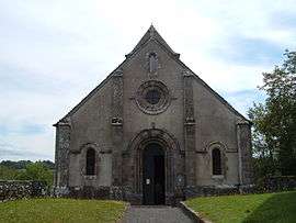 The church of Saint-Thibaud, in Brageac | |
 Brageac Location within Auvergne-Rhône-Alpes region  Brageac | |
| Coordinates: 45°12′18″N 2°17′20″E / 45.205°N 2.2889°ECoordinates: 45°12′18″N 2°17′20″E / 45.205°N 2.2889°E | |
| Country | France |
| Region | Auvergne-Rhône-Alpes |
| Department | Cantal |
| Arrondissement | Mauriac |
| Canton | Mauriac |
| Intercommunality | Pays de Salers |
| Government | |
| • Mayor (2008–2014) | André Dayral |
| Area1 | 12.23 km2 (4.72 sq mi) |
| Population (2008)2 | 74 |
| • Density | 6.1/km2 (16/sq mi) |
| Time zone | UTC+1 (CET) |
| • Summer (DST) | UTC+2 (CEST) |
| INSEE/Postal code | 15024 /15700 |
| Elevation |
288–686 m (945–2,251 ft) (avg. 720 m or 2,360 ft) |
|
1 French Land Register data, which excludes lakes, ponds, glaciers > 1 km2 (0.386 sq mi or 247 acres) and river estuaries. 2 Population without double counting: residents of multiple communes (e.g., students and military personnel) only counted once. | |
Brageac is a commune in the Cantal department in south-central France.
Population
| Historical population | ||
|---|---|---|
| Year | Pop. | ±% |
| 1962 | 86 | — |
| 1968 | 107 | +24.4% |
| 1975 | 92 | −14.0% |
| 1982 | 80 | −13.0% |
| 1990 | 64 | −20.0% |
| 1999 | 67 | +4.7% |
| 2008 | 74 | +10.4% |
See also
References
| Wikimedia Commons has media related to Brageac. |
This article is issued from
Wikipedia.
The text is licensed under Creative Commons - Attribution - Sharealike.
Additional terms may apply for the media files.