Fontanges
| Fontanges | ||
|---|---|---|
| Commune | ||
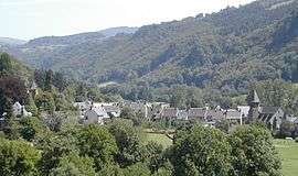 A general view of Fontanges | ||
| ||
 Fontanges Location within Auvergne-Rhône-Alpes region  Fontanges | ||
| Coordinates: 45°06′52″N 2°30′17″E / 45.1144°N 2.5047°ECoordinates: 45°06′52″N 2°30′17″E / 45.1144°N 2.5047°E | ||
| Country | France | |
| Region | Auvergne-Rhône-Alpes | |
| Department | Cantal | |
| Arrondissement | Mauriac | |
| Canton | Mauriac | |
| Intercommunality | Pays de Salers | |
| Government | ||
| • Mayor (2008–2014) | Pierre Champagnac | |
| Area1 | 18.04 km2 (6.97 sq mi) | |
| Population (2008)2 | 220 | |
| • Density | 12/km2 (32/sq mi) | |
| Time zone | UTC+1 (CET) | |
| • Summer (DST) | UTC+2 (CEST) | |
| INSEE/Postal code | 15070 /15140 | |
| Elevation |
664–1,246 m (2,178–4,088 ft) (avg. 630 m or 2,070 ft) | |
|
1 French Land Register data, which excludes lakes, ponds, glaciers > 1 km2 (0.386 sq mi or 247 acres) and river estuaries. 2 Population without double counting: residents of multiple communes (e.g., students and military personnel) only counted once. | ||

Fontanges is a commune in the Cantal department in south-central France.
Geography
The Aspres river flows through the commune.
Population
| Historical population | ||
|---|---|---|
| Year | Pop. | ±% |
| 1962 | 399 | — |
| 1968 | 454 | +13.8% |
| 1975 | 353 | −22.2% |
| 1982 | 307 | −13.0% |
| 1990 | 292 | −4.9% |
| 1999 | 241 | −17.5% |
| 2008 | 220 | −8.7% |
See also
References
| Wikimedia Commons has media related to Fontanges (Cantal). |
This article is issued from
Wikipedia.
The text is licensed under Creative Commons - Attribution - Sharealike.
Additional terms may apply for the media files.