Saint-Mamet-la-Salvetat
| Saint-Mamet-la-Salvetat | ||
|---|---|---|
| Commune | ||
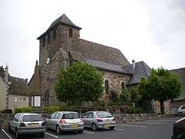 The church in Saint-Mamet-la-Salvetat | ||
| ||
 Saint-Mamet-la-Salvetat Location within Auvergne-Rhône-Alpes region  Saint-Mamet-la-Salvetat | ||
| Coordinates: 44°51′32″N 2°18′28″E / 44.8589°N 2.3078°ECoordinates: 44°51′32″N 2°18′28″E / 44.8589°N 2.3078°E | ||
| Country | France | |
| Region | Auvergne-Rhône-Alpes | |
| Department | Cantal | |
| Arrondissement | Aurillac | |
| Canton | Maurs | |
| Intercommunality | Entre Cère et Rance | |
| Government | ||
| • Mayor (2008–2014) | Eric Fevrier | |
| Area1 | 51.49 km2 (19.88 sq mi) | |
| Population (2008)2 | 1,453 | |
| • Density | 28/km2 (73/sq mi) | |
| Time zone | UTC+1 (CET) | |
| • Summer (DST) | UTC+2 (CEST) | |
| INSEE/Postal code | 15196 /15220 | |
| Elevation |
499–790 m (1,637–2,592 ft) (avg. 742 m or 2,434 ft) | |
|
1 French Land Register data, which excludes lakes, ponds, glaciers > 1 km2 (0.386 sq mi or 247 acres) and river estuaries. 2 Population without double counting: residents of multiple communes (e.g., students and military personnel) only counted once. | ||
.svg.png)
Saint-Mamet-la-Salvetat is a commune in the Cantal department in south-central France.
Population
| Historical population | ||
|---|---|---|
| Year | Pop. | ±% |
| 1962 | 1,062 | — |
| 1968 | 1,153 | +8.6% |
| 1975 | 1,200 | +4.1% |
| 1982 | 1,236 | +3.0% |
| 1990 | 1,327 | +7.4% |
| 1999 | 1,321 | −0.5% |
| 2008 | 1,453 | +10.0% |
See also
References
| Wikimedia Commons has media related to Saint-Mamet-la-Salvetat. |
This article is issued from
Wikipedia.
The text is licensed under Creative Commons - Attribution - Sharealike.
Additional terms may apply for the media files.