Vitrac, Cantal
| Vitrac | |
|---|---|
| Commune | |
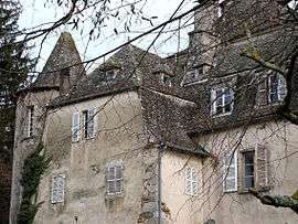 The Chateau de Fargues, in Vitrac | |
 Vitrac Location within Auvergne-Rhône-Alpes region  Vitrac | |
| Coordinates: 44°48′58″N 2°18′56″E / 44.8161°N 2.3156°ECoordinates: 44°48′58″N 2°18′56″E / 44.8161°N 2.3156°E | |
| Country | France |
| Region | Auvergne-Rhône-Alpes |
| Department | Cantal |
| Arrondissement | Aurillac |
| Canton | Maurs |
| Intercommunality | Entre Cère et Rance |
| Government | |
| • Mayor (2008–2014) | Marie-Paule Cassagne |
| Area1 | 17.88 km2 (6.90 sq mi) |
| Population (2008)2 | 293 |
| • Density | 16/km2 (42/sq mi) |
| Time zone | UTC+1 (CET) |
| • Summer (DST) | UTC+2 (CEST) |
| INSEE/Postal code | 15264 /15220 |
| Elevation |
444–786 m (1,457–2,579 ft) (avg. 550 m or 1,800 ft) |
|
1 French Land Register data, which excludes lakes, ponds, glaciers > 1 km2 (0.386 sq mi or 247 acres) and river estuaries. 2 Population without double counting: residents of multiple communes (e.g., students and military personnel) only counted once. | |
Vitrac is a commune in the Cantal department in south-central France.
Population
| Historical population | ||
|---|---|---|
| Year | Pop. | ±% |
| 1962 | 395 | — |
| 1968 | 409 | +3.5% |
| 1975 | 404 | −1.2% |
| 1982 | 347 | −14.1% |
| 1990 | 294 | −15.3% |
| 1999 | 277 | −5.8% |
| 2008 | 293 | +5.8% |
See also
References
| Wikimedia Commons has media related to Vitrac (Cantal). |
This article is issued from
Wikipedia.
The text is licensed under Creative Commons - Attribution - Sharealike.
Additional terms may apply for the media files.