Massiac
| Massiac | ||
|---|---|---|
| Commune | ||
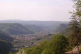 Massiac seen from the Alagnonnette valley | ||
| ||
 Massiac Location within Auvergne-Rhône-Alpes region  Massiac | ||
| Coordinates: 45°15′07″N 3°11′53″E / 45.2519°N 3.1981°ECoordinates: 45°15′07″N 3°11′53″E / 45.2519°N 3.1981°E | ||
| Country | France | |
| Region | Auvergne-Rhône-Alpes | |
| Department | Cantal | |
| Arrondissement | Saint-Flour | |
| Canton | Saint-Flour-1 | |
| Intercommunality | Pays de Massiac | |
| Government | ||
| • Mayor (2008–2014) | Michel Destannes | |
| Area1 | 34.78 km2 (13.43 sq mi) | |
| Population (2008)2 | 1,833 | |
| • Density | 53/km2 (140/sq mi) | |
| Time zone | UTC+1 (CET) | |
| • Summer (DST) | UTC+2 (CEST) | |
| INSEE/Postal code | 15119 /15500 | |
| Elevation |
511–1,005 m (1,677–3,297 ft) (avg. 540 m or 1,770 ft) | |
|
1 French Land Register data, which excludes lakes, ponds, glaciers > 1 km2 (0.386 sq mi or 247 acres) and river estuaries. 2 Population without double counting: residents of multiple communes (e.g., students and military personnel) only counted once. | ||
.svg.png)
Massiac is a commune in the Cantal department in south-central France.
Population
| Historical population | ||
|---|---|---|
| Year | Pop. | ±% |
| 1962 | 1,741 | — |
| 1968 | 1,756 | +0.9% |
| 1975 | 1,884 | +7.3% |
| 1982 | 1,838 | −2.4% |
| 1990 | 1,881 | +2.3% |
| 1999 | 1,857 | −1.3% |
| 2008 | 1,833 | −1.3% |
See also
References
External links
| Wikimedia Commons has media related to Massiac. |
This article is issued from
Wikipedia.
The text is licensed under Creative Commons - Attribution - Sharealike.
Additional terms may apply for the media files.